Sites: news | india | latam | brasil | indonesia
Feeds: news | india | latam | brasil | indonesia
topic: Remote Sensing
Social media activity version | Lean version
Despite drought, Amazon deforestation alerts hit five-year low
- The Brazilian Amazon experienced a 47% decrease in deforestation in April compared to last year, marking the lowest level in five years, and a 51% decrease over the past 12 months.
- Since President Luiz Inácio Lula da Silva took office in January 2023, his administration has effectively curbed deforestation by reinstating conservation programs, strengthening environmental agencies, and supporting Indigenous rights.
- The decline in deforestation occurred despite a severe drought affecting the region, which includes record fires in the state of Roraima.
New technologies to map environmental crime in the Amazon Basin (commentary)
- Environmental crimes like land grabbing, illegal deforestation, and poaching hinder climate action, deter investment in sustainable practices, and threaten biodiversity across major biomes worldwide.
- Despite challenges such as vast territories difficult to police and weak rule of law, new technologies like geospatial and predictive analytics are being leveraged to enhance the detection and disruption of these activities.
- Innovative approaches, including public-private partnerships and AI tools, show promise in improving real-time monitoring and enforcement, although they require increased investment and training to be truly effective, argue Robert Muggah and Peter Smith of Instituto Igarapé, a “think and do tank” in Brazil.
- This post is a commentary. The views expressed are those of the authors, not necessarily Mongabay.
Fires surge in the Amazon, but deforestation continues to fall
- Deforestation in the Brazilian Amazon has continued on a downward trajectory despite a sharp increase in fires associated with the severe drought in the region.
- According to data published by Brazil’s National Space Research Institute (INPE) earlier this month, forest loss in the Brazilian Amazon amounted to 5,010 square kilometers over the past twelve months, the lowest level recorded since May 2019.
- Despite the declining rate of forest loss, fires in the Amazon are on the rise, driven by the severe drought gripping the region.
- Deforestation in the Brazilian Amazon has fallen precipitously since Luiz Inácio Lula da Silva replaced Jair Bolsonaro as president last year.
2024 outlook for rainforests
- Last week, Mongabay published a recap of the major trends in the world’s tropical rainforests for 2023.
- Here’s a brief look at some of the key issues to monitor in 2024.
- These include: Brazil, elections in DRC and Indonesia, forest carbon markets, el Niño, global inflation and commodity prices, advancements in forest data, and progress on high level commitments.
The year in rainforests: 2023
- The following is Mongabay’s annual recap of major tropical rainforest storylines.
- While the data is still preliminary, it appears that deforestation declined across the tropics as a whole in 2023 due to developments in the Amazon, which has more than half the world’s remaining primary tropical forests.
- Some of the other big storylines for the year: Lula prioritizes the Amazon; droughts in the Amazon and Indonsia; Indonesia holds the line on deforestation despite el Niño; regulation on imports of forest-risk commodities; an eventful year in the forest carbon market; rainforests and Indigenous peoples; and rampant illegality.
Deforestation falls for 8th straight month in the Amazon rainforest, but rises in the cerrado
- Deforestation in the Brazilian Amazon has decreased for the eighth consecutive month, but damage is rising in the cerrado, a tropical woody grassland that’s adjacent to Earth’s largest rainforest.
- According to data released today by Brazil’s National Space Research Institute (INPE), forest clearing in November totaled 201 square kilometers, bringing the cumulative loss for the past 12 months to 5,206 square kilometers – 51% less than last year.
- The decline in deforestation has persisted despite one of the most severe droughts ever recorded in the Amazon.
- However, while deforestation in the Amazon rainforest has decreased, it has reached the highest level in at least five years in the cerrado.
Deforestation in the Brazilian Amazon falls 22% in 2023
- Deforestation in Earth’s largest rainforest decreased by 22% in the year ending July 31, 2023, according to data released on Thursday by Brazil’s National Space Research Institute (INPE).
- INPE’s analysis of satellite imagery found that forest clearing in the Brazilian Amazon totaled 9,001 square kilometers, an area approximately the size of Puerto Rico.
- INPE’s estimate is preliminary. Final data for the “deforestation year” is expected to come out in the second quarter of 2024.
- Nevertheless, the data is seen as a sign that President Luiz Inácio Lula da Silva’s efforts to curb deforestation is having an effect after a period of rising forest loss under Jair Bolsonaro.
Can digital twins help save the Amazon? (commentary)
- Spread across highland forests, tropical steppes, and low-lying floodplains — all of which are affected by varying degrees of human influence — the Amazon is a complex ecosystem. Yet, it remains inadequately mapped.
- Considering the degree of threat facing the Amazon and its global importance, it is critical to develop better methods for monitoring and comprehending this ecosystem.
- Carlo Ratti, the director of MIT’s Senseable City Lab, and Robert Muggah, the co-founder of the Igarapé Institute, argue that creating a “digital twin” of the Amazonian ecosystem could potentially serve as a means to aid its preservation while fostering a regional bioeconomy.
- This post is a commentary. The views expressed are those of the authors, not necessarily of Mongabay.
Sound recordings and AI tell us if forests are recovering, new study from Ecuador shows
- Acoustic monitoring and AI tools were used to track biodiversity recovery in plots of tropical Chocó forest in northwestern Ecuador.
- The study found that species returned to regenerating forests in as little as 25 years, indicating positive progress in forest recovery.
- Acoustic monitoring and AI-based methods proved to be powerful and cost-effective techniques for assessing biodiversity levels in restored forests, including insects and animals that don’t vocalize.
- The authors hope these methods make biodiversity monitoring more transparent, accountable, and accessible to support land managers and market-based conservation mechanisms that rely on forest restoration, such as payments for ecosystem services.
Origami-inspired sensor platforms tumble like leaves to study forests
- Scientists have developed a tiny, lightweight, shape-shifting platform that can hold a variety of environmental sensors and be dropped from drones to study far-flung locations.
- The design for the platforms, known as microfliers, was inspired by origami, the Japanese art of paper folding.
- Each microflier can snap between two shapes while in the air, allowing them to have different trajectories and thus disperse across a larger area when they land.
- Though they haven’t been used in any scientific studies yet, microfliers could be useful for the large-scale deployment of environmental sensors measuring and transmitting data on pressure, temperature, humidity, or lighting conditions, among others.
Despite severe drought, Amazon deforestation continues to slow
- Despite a severe drought, deforestation in the Brazilian Amazon is still on the decline, according to data released today Brazil’s national space research institute (INPE).
- INPE’s near-real-time deforestation monitoring system, DETER, detected 629 square kilometers of forest clearing in September, a 57% drop from last September.
- This decline in forest loss has occurred despite a severe drought that is affecting vast swathes of the Brazilian Amazon, drying up rivers and worsening the spread of agricultural fires.
Protected areas a boon for vertebrate diversity in wider landscape, study shows
- A new study reveals that protected areas in Southeast Asia not only boost bird and mammal diversity within their confines, but they also elevate numbers of species in nearby unprotected habitats.
- The researchers say their findings back up the U.N.’s 30×30 target to protect 30% of Earth’s lands and waters by 2030.
- The findings indicate that larger reserves result in more spillover of biodiversity benefits into surrounding landscapes. The authors call on governments to invest in expanding larger reserves over the proliferation of smaller ones.
- Conservationists say that while expanding protected area coverage is part of the solution, serious investment in management and resourcing for existing protected areas is a matter of urgency to ensure they are not simply “paper parks.”
Deforestation in the Amazon rainforest continues to plunge
- Deforestation in the Brazilian Amazon continues to decline, according to data released today by Brazil’s national space research institute, INPE.
- INPE’s deforestation alert system indicates that forest clearing in Brazil’s portion of the Amazon in August declined 66% compared to the same month last year.
- Deforestation in the Brazilian Amazon has seen a decrease for five consecutive months. This follows President Luiz Inácio Lula da Silva’s commitment to curb the escalating forest loss in the region.
- Brazil is set to release its annual assessment of deforestation for the year ending July 31 in the coming weeks.
How the Amazon’s ‘greatest devastator’ sold cattle to a Carrefour supplier
- Arrested by Brazilian Federal Police, cattle rancher Bruno Heller and relatives have already received over $5 million in environmental fines. He is also suspected of land grabbing.
- Heller transported cattle from a family farm fined for environmental violations to two other properties free from environmental implications — this maneuver is an indication of the so-called “cattle laundering.”
- A Frialto Group meatpacking plant confirmed that it slaughtered 249 animals for the Heller family. The facility supplies Carrefour, but the French retail company states that the meat from animals raised by Heller did not reach its supermarkets.
Amazon deforestation continues to fall under Lula
- Deforestation in the Brazilian Amazon plunged sharply in July, continuing a downward trend since President Luiz Inácio Lula da Silva took office at the beginning of the year.
- The analysis of satellite data from Brazil’s national space research institute showed that 500 square kilometers (193 square miles) of tropical rainforest were cleared in Brazil’s portion of the Amazon during the month of July. This represents a 66% decline relative to July a year ago when Jair Bolsonaro was president.
- The news comes just days before leaders from eight Amazonian nations will meet in Belém to discuss ways to protect and sustainably manage Earth’s largest rainforest.
- The decline in Brazil’s rate of deforestation marks a sharp reversal relative to the trend under the Bolsonaro Administration, during which forest destruction surged.
Six months into Lula’s presidency, Amazon deforestation is dropping rapidly
- The rate of deforestation in the Brazilian Amazon has fallen significantly since Luiz Inácio Lula da Silva took office in January 2023, according to government data.
- The area of deforestation detected by INPE’s forest monitoring system amounted to 2,649 square kilometers in the first half of the year, a 34% decline last year.
- Lula has prioritized reining in deforestation since assuming the presidency. Last month, he announced his administration’s plan to eliminate deforestation by 2030 as part of Brazil’s pledge to reduce greenhouse gas emissions.
Nearly 30% of all tree cover in Africa may be outside of forests, study says
- A team at the University of Copenhagen has generated a map of tree cover in 45 African countries down to individual tree crowns by feeding high-resolution satellite imagery into a machine-learning model.
- The analysis showed that nearly 30% of the continent’s tree cover lies outside what are traditionally considered forest areas in land-cover maps.
- For nine countries, trees outside forests account for around half their tree cover: Botswana, Burkina Faso, Eritrea, Libya, Mali, Namibia, Niger, Mauritania and Sudan.
- Such high-resolution tree-cover data could lead to more precise carbon stock assessments and better monitoring of land-use changes.
Deforestation accelerated in Brazil while climate talks were underway in Egypt
- Deforestation in Earth’s largest rainforest accelerated sharply during the month of November when U.N. climate talks were underway in Egypt, according to data released today.
- Brazil’s national space research institute INPE detected 555 square kilometers (214 square miles) of forest clearing during November, about 60% above average for the month over the past seven years and more than twice last November’s rate.
- Deforestation in the Brazilian Amazon has been trending upward since 2012 but incoming president Luiz Inácio Lula da Silva has pledged to better protect the region’s forests.
Despite 11% drop in 2022, Amazon deforestation rate has soared under Bolsonaro
- An area equivalent to the size of Qatar was cleared in the Brazilian Amazon between Aug. 1, 2021, and July 31, 2022, according to data from the country’s National Space Research Institute (INPE).
- Although the figure represents an 11.27% decrease in the Amazon annual deforestation rate compared with the prior year, the government of President Bolsonaro still accounts for the most Amazon destruction in the last 34 years, environmentalists say.
- Bolsonaro’s four-year term ends with a 59.5% boom in Amazon deforestation rates, the highest in a presidential term since 1988, when measurements by satellite imagery began.
- INPE’s report, dated Nov. 3 but only released 27 days later, also triggered criticism among environmentalists, who accused the Bolsonaro’s administration of omitting the annual deforestation data until the end of the UN conference on climate change, COP27, held Nov. 6-20 in Egypt.
In final days before Bolsonaro’s defeat, deforestation boomed in Brazil
- According to data published today by Brazil’s national space research agency INPE, deforestation in the Brazilian Amazon amounted to 904 square kilometers in October, a 3% increase over last year.
- Year to date, INPE’s deforestation alert system has detected 9,494 square kilometers of forest clearing, 20% more than 2021.
- The figures came less than two weeks after Luiz Inácio Lula da Silva narrowly defeated Jair Bolsonaro in a run off election. Lula, who presided over a sharp drop in Amazon forest deforestation during his terms in office between 2003 and 2010, made saving the Amazon a key part of his bid for the presidency.
- In contrast, Bolsonaro has overseen a steep rise in deforestation, which hit a 15-year high last year.
Ahead of election, deforestation increased in Brazil
- Deforestation in the Amazon rainforest is surging ahead of the presidential election in Brazil.
- According to data released today by Brazil’s national space research agency INPE, deforestation in the Brazilian Amazon topped 1,450 square kilometers in September, a 48% increase over last year.
- Deforestation through the first nine months of 2022 has amounted to 8,590 square kilometers, the highest such tally on record since the current deforestation alert system was established in 2007.
Crimes against the Amazon reverberate across Brazil, analysis shows
- Crimes associated with illegal logging, mining and other illicit activities in the Brazilian Amazon are being felt in 24 of Brazil’s 27 states, a new report shows.
- Records of more than 300 Federal Police operations between 2016 and 2021 show that crimes such as tax evasion, money laundering, corruption and wildlife trafficking are reverberating far beyond the rainforest.
- Deforestation is at the center of the criminal economy in the Amazon, driving four main illegal activities: logging, mining, occupation of public lands, and environmental violations associated with agriculture.
- Nearly half of the police operations investigated crimes that occurred in protected areas in the Amazon, including 37 Indigenous territories.
Indepedent watchdog confirms rampant deforestation in the Amazon
- Data from independent forest monitoring group Imazon has confirmed that deforestation in Earth’s largest rainforest is on track to approach the highest level in 15 years.
- Imazon’s monthly deforestation alert system detected 10,781 square kilometers of forest clearing in the Brazilian Amazon betwen August 2021 to July 2022, a 3% rise over the same period last year when forest destruction reached the highest level since 2006.
- Imazon’s update came shortly after INPE, Brazil’s national space research institute, published its own deforestation alert-based data.
- Deforestation in the Brazilian Amazon has been on an upward trend since 2012.
Amazon deforestation on pace to roughly match last year’s rate of loss
- Deforestation in Earth’s largest rainforest is on track to rival last year’s 15-year-high according to data released today by the Brazilian government.
- INPE, Brazil’s national space research institute, today published figures from its DETER deforestation alert system, which tracks forest clearing on a near-real time basis. INPE’s system detected 8,590 square kilometers of deforestation between August 1, 2021 and July 31, 2022, 2.3% lower than the previous year, when deforestation hit the highest level since 2006.
- The area of forest affected by degradation and selected cutting, which is typically a precursor to outright deforestation, climbed 15.6% year over year.
- 2022’s tally represents an area nearly the size of Puerto Rico or Cypress. But the actual area of forest loss over the past 12 months is significantly higher: INPE is expected to release its findings from analysis of high resolution satellite imagery in October or November.
Amazon deforestation is off to the fastest start to a year since 2008
- Deforestation in the Brazilian Amazon is off to the fastest start for the first half of any year since 2008 according to government data published today.
- Deforestation alert data from Brazil’s national space research institute INPE shows that 3,988 square kilometers of forest have been cleared within the Brazilian Amazon since January 1, a 17 percent rise over last year.
- Deforestation in the Brazilian Amazon reached a 15-year high in 2021.
For fire-ravaged northern Thailand, there’s now an app to battle the blaze
- Thai researchers incorporating remote-sensing technology into smartphone applications are helping to reduce the severity of forest fires in the country’s northern Chiang Rai province.
- In the past, only local officials had access to hotspot data from satellites; now, whenever a new hotspot is identified, firefighters and nearby communities alike receive notifications on their mobile apps.
- The app has enabled villagers, firefighters, NGOs and scientists to “join forces” in fighting forest fires, and encouraged communities to police and reduce unregulated burning of agricultural land.
- The researchers are currently working on a second app that aims to help local communities transition toward more sustainable ways of clearing and fertilizing their land than burning.
Tech revolution holds world of promise for conservation, but challenges persist
- Technology has rapidly changed the face of conservation and is now at a critical juncture where cutting edge tools are available, but aren’t necessarily as accessible or affordable as they need to be.
- A recent survey by WILDLABS, an online platform connecting conservation technology experts, shows that environmental DNA, networked sensors and artificial intelligence tools are the fields that hold the most promise.
- Yet despite the progress that’s been made, there are still many barriers to accessibility for local and Indigenous communities.
- Experts say collaboration and partnerships between conservationists, tech developers and local and Indigenous communities will be key to ensuring that conservation tech can continue having an impact.
The year in rainforests 2021
- 2021 was a year where tropical forests featured more prominently in global headlines than normal thanks to rising recognition of the role they play in addressing climate change and biodiversity loss.
- Despite speculation in the early months of the pandemic that slowing economic activity might diminish forest clearing, loss of both primary forests and tree cover in the tropics accelerated between 2019 and 2020. We don’t yet know how much forest was cut down in 2021, but early indications like rising deforestation in the Brazilian Amazon suggest that forest loss will be on the high end of the range from the past decade.
- The following is a look at some of the major tropical rainforest storylines from 2021. It is not an exhaustive review.
Bioacoustics researcher wins top award for positive impact toward solving global challenges
- An award that recognizes scientists whose research makes a positive impact on society by addressing global challenges has been given to Zuzana Burivalova.
- The principal investigator for the Sound Forest Lab at the University of Wisconsin-Madison, much of her bioacoustics research has focused on soundscapes, which are entire sonic characteristics of ecosystems.
- Monitoring soundscapes has important conservation applications in places like tropical rainforests where Burivalova’s work is centered.
With La Niña conditions back, is it good news for tropical forests?
- La Niña conditions have developed across the Pacific Ocean for the second year in a row, according to forecasters at NOAA’s Climate Prediction Center.
- A phase of the El Niño Southern Oscillation ocean-atmosphere cycle, La Niña heralds broadly cooler and wetter conditions across the tropics, with above-average rainfall predicted for important tropical rainforests in Southeast Asia and South America.
- Although the current conditions emerge toward the end of the fire season in the Amazon and Indonesia, experts say these biomes will benefit from wet conditions conducive to forest and peatland growth and recovery.
- Studies indicate that climate change will increase the frequency and severity of La Niña and El Niño events, which will occur against the backdrop of a warmer world, with inevitable implications for natural ecosystems and livelihoods.
Amazon deforestation unexpectedly surges 22% to highest level since 2006
- Deforestation in Earth’s largest rainforest surged 22% to the highest level since 2006, according to official data released today by the Brazilian government.
- Preliminary analysis of satellite data by Brazil’s national space research institute INPE shows that 13,235 square kilometers (5,110 square miles) of rainforest was cleared in the Brazilian Amazon between August 1, 2020 and July 31, 2021.
- The sharp increase came as a surprise: Data from INPE’s near-real-time deforestation alert system had set expectations for a modest year-over-year decline in the rate of forest destruction.
- Deforestation has been on an upward trend in the Brazilian Amazon since 2012.
The Amazon has highest October forest loss since at least 2007
- On Friday Brazil reported the highest level of deforestation for any October dating back to 2007.
- According to data from Brazil’s national space research institute INPE, 877 square kilometers (339 square miles) of rainforest were destroyed in the Brazilian Amazon, a 5% increase over October 2020.
- It marks the second straight month where the rate of forest clearing has risen, but on a trailing-twelve-month basis, deforestation stands 5% lower than the same time last year.
- Brazil is expected to release its preliminary deforestation for the year ended July 31, 2021 later this month. It will likely show about a 10% decline relative to 2020.
What countries are leaders in reducing deforestation? Which are not?
- On Tuesday, 127 countries signed the Glasgow Leaders’ Declaration on Forests and Land Use, pledging to “halt and reverse forest loss and land degradation” by 2030. The declaration was endorsed outside the United Nations Framework Convention on Climate Change (UNFCCC) process and is therefore legally non-binding.
- The 127 signatories account for about 90% of global tree cover and 85% of the world’s primary tropical forests. The Glasgow Declaration thus represents a much larger constituency than the 39 countries which signed the New York Declaration on Forests in 2014. That latter effort failed badly in its ambition to halve deforestation by 2020 — forest loss rose substantially in signatories’ territories.
- Given the extent to which the New York Declaration missed its near-term numeric target on a national level basis, it’s worth breaking down the aggregate data to look at countries on an individual basis to see where forest loss declined and increased.
- Indonesia experienced the biggest decline in primary tropical forest loss, while Brazil saw its primary forest loss more than double from 4.65 million ha to 9.4 million ha. Canada experienced the biggest decline in the extent of tree cover loss, while Brazil also led the world in terms of increase in tree cover loss.
Data-driven platform looks to clear up fog of palm oil traceability
- A new web-based monitoring platform, Palmoil.io, has been launched to help the palm oil industry fully trace its product back to its origin to make sure that it’s legally sourced and sustainably produced.
- Existing supply chain monitoring efforts remain fragmented, expensive and uneven as they struggle to trace palm oil product through a complex web of plantations and mills.
- Palmoil.io aims to address this by collecting and analyzing data on more than 2,000 palm mills, 480 refineries and crushers, and 400 high-risk plantations.
- The large, and growing, volume of data will enables Palmoil.io to trace palm oil product to its source and determine whether it’s associated with comes from deforestation, as well as human rights and labor violations or not.
To predict forest loss in protected areas, look at nearby unprotected forest
- To predict deforestation risk in a protected area, look at the condition of its surrounding forests, according to a new study.
- The study, which analyzed satellite images of protected forests worldwide, found nearby forest loss to be a consistent early warning signal of future deforestation in protected areas.
- Researchers said national park agencies can use their proposed model to predict how vulnerable protected areas in their countries are to deforestation, and prioritize conservation efforts accordingly.
- But even as these agencies work to protect forests, they should take into account the needs of local communities living in the area, the researchers said.
Brazil reports increase in Amazon logging
- Selective forest cutting in the Amazon is on the rise, according to data released on Friday by the Brazilian government.
- INPE reported a 77% increase in the rate of cutting that’s typically associated with logging, from 646 square kilometers in September 2020 to 1,145 square kilometers last month. Selective cutting in the region currently stands at the highest level in at least five years.
- The rise in logging is significant because logged areas in the Amazon are more likely to be eventually deforested. Selectively logged forests also face higher fire risk due to drier conditions relative to intact rainforests.
After surge, Amazon deforestation slows for second straight month
- Deforestation in the Brazilian Amazon declined for the second straight month according to data released today by Brazil’s national space research institute INPE.
- Year to date, INPE’s DETER deforestation alert system has registered 5,822 square kilometers of forest clearance. At this time last year the tally stood at 6,099 square kilometers.
- Deforestation in the Brazilian Amazon hit a 12-year high last year.
Independent monitoring suggests sharp jump in Amazon rainforest destruction
- Independent analysis released last week by a Brazilian NGO provides evidence of a sharp increase in the rate of forest destruction in Earth’s largest rainforest over the past year.
- Imazon’s SAD deforestation alert system detected 2,095 square kilometers (809 square miles) of forest clearing during July, which brought the total deforestation recorded since August 1, 2020 to 10,476 square kilometers, the highest on record since at least 2008.
- By Imazon’s count, the amount of forest loss detected by its deforestation monitoring system was up 58% over a year ago, and 107% relative to two years ago.
- In contrast, Brazil’s national space research institute INPE reported a 6.8% drop in deforestation compared to a year ago when it released its alert-based data two weeks ago. Discrepancies between the two systems can be attributed up to differences in how they measure deforestation, though the data from the systems typically move mostly in tandem.
Loss of mangroves dims the light on firefly populations in Malaysia
- Firefly populations along the banks of the Rembau River in Malaysia have declined drastically in the past decade due to habitat loss, a new study has found.
- Researchers, who used satellite imagery to monitor changes in land use, found that conversion of Rembau’s mangroves to oil palm plantations and dryland forests were the top two factors behind the loss.
- Remote-sensing technology could help locals better understand the impact of various land use types on mangrove ecosystems and more efficiently prioritize areas for conservation.
July data put Brazil on track for slight reduction in Amazon deforestation
- Deforestation in the Brazilian Amazon is on track for the first year-over-year decline since President Jair Bolsonaro took office, according to data released today by the country’s national space research institute INPE.
- INPE’s satellite-based deforestation alert system has recorded 1,417 square kilometers (547 square miles) of forest clearing through the first 30 days of July. Final figures for the month are expected next week.
- But the new data won’t ease worries about trends in the Amazon. On Tuesday, Brazil’s lower house of Congress passed a bill that critics say will legalize illegal land-grabbing in the Amazon.
- Environmentalists and scientists are also concerned that forest loss could worsen in coming months due to abnormally dry conditions across vast swathes of the Amazon.
More than 250 major fires detected in the Amazon this year, despite Brazil’s ban
- There have been 267 major fires detected in the Amazon this year, burning more than 105,000 hectares (260,000 acres) — an area roughly the size of Los Angeles, California.
- More than 75% of these fires blazed in the Brazilian Amazon, in areas where trees have been cut to make way for agriculture, despite a June 27 ban on unauthorized outdoor fires by the Brazilian government.
- The first forest fires of the season have also been detected, those that have escaped pastures and burned standing Amazon rainforest, where fires are not historically naturally occurring.
- A historic drought, rampant deforestation, and lax environmental regulations mean this year is likely to be a bad year for fires, experts say.
Arboreal camera traps add ‘tons of value’ to forest canopy research
- The burgeoning field of arboreal camera trapping is revealing new knowledge about tree-dwelling species.
- Recent advances in camera technology, climbing techniques and safety equipment have brought the forest canopy more easily within researchers’ reach.
- A new study compiles knowledge from 90 arboreal camera-trapping studies in 24 countries across six continents to help future researchers plan, design and execute surveys.
- The study provides a foundation from which to develop standardized arboreal camera-trapping approaches that will allow researchers to compare data across projects and locations and reveal important global biodiversity patterns.
New index measuring rainforest vulnerability to sound alarm on tipping points
- The new Tropical Forest Vulnerability Index (TFVI) will use satellite data to assess the impact of growing threats such as land clearance and rising temperatures on forests.
- Backed by the National Geographic Society and Swiss watchmaker Rolex, TFVI aims to identify forests most at risk, to be prioritized for conservation efforts.
- Researchers combined 40 years of satellite measurements and forest observations covering tropical forests worldwide to come up with the standardized monitoring system.
- In recent years, multiple stressors have pushed forests to a tipping point, causing them to gradually lose their ecological functions, including their capacity to store carbon and recycle water, the study says.
Betting big on bioacoustics: Q&A with philanthropist Lisa Yang
- Lisa Yang is an investor and philanthropist who donated $24 million last month to establish the K. Lisa Yang Center for Conservation Bioacoustics at the Cornell Lab of Ornithology.
- Yang told Mongabay that she focused on bioacoustics due to the great potential for scaling the effectiveness of conservation efforts: “The technology can provide an effective way of assessing conservation practices.”
- Yang’s philanthropic interests extend to translational neuroscience and fostering opportunities and respect for people who’ve been historically marginalized by society, including the “neurodiverse and individuals with disabilities.”
- Yang spoke about opportunities to scale impact in conservation during a conversation with Mongabay founder Rhett A. Butler.
How to make conservation more effective: Q&A with Nick Salafsky
- The multifaceted nature of most conservation projects means that many factors need to be monitored and evaluated using a range of metrics to determine whether a real impact has been achieved and can be sustained into the future.
- One of the organizations at the forefront of efforts to measure impact in conservation over the past twenty years has been Foundations of Success, which developed its roots in the 1990s out of a need to develop ways to gauge the success of U.S. government-funded conservation projects.
- From his position as the co-founder and Executive Director of Foundations of Success, Nick Salafsky has seen firsthand how organizations and institutions are responding to the growing preponderance of data and the emergence of new technologies and tools in the conservation space. He says that an organization’s receptiveness to change when more effective pathways are identified is important to achieving conservation success.
- “Perhaps the most important predictor of success is the attitude of the people in an organization – whether they are ultimately interested in merely perpetuating their programs and their jobs versus being open and willing to critically examine and learn from their work,“ he told Mongabay’s founder Rhett A. Butler in a recent interview.
Armed with data and smartphones, Amazon communities boost fight against deforestation
- Equipping Indigenous communities in the Amazon with remote-monitoring technology can reduce illegal deforestation, a new study has found.
- Between 2018 and 2019, researchers implemented technology-based forest-monitoring programs in 36 communities within the Peruvian Amazon.
- Compared with other communities where the program wasn’t implemented, those under the program saw 52% and 21% less deforestation in 2018 and 2019 respectively.
- The gains were concentrated in communities at highest risk of deforestation due to threats like logging and illegal mining.
Amazon deforestation rises modestly in June
- Deforestation in the Brazilian Amazon continued on an upward trajectory in June, reports the country’s national space research institute INPE.
- INPE’s satellite-based forest monitoring system detected 1,062 square kilometers of deforestation during June, an area 311 times the size of New York City’s Central Park.
- The forest clearing represents a 2% rise over June a year ago. Deforestation has now risen three consecutive months in the region, but is pacing 11% behind last year’s rate, when forest loss in Earth’s largest rainforest reached a 12-year high.
Fire season intensifies in the Brazilian Amazon, feeding off deforestation
- Twenty-four major fires have burned in the Brazilian Amazon so far this year, all of them set on land previously deforested in 2020, until this week when the first major blaze was set on land cleared in 2021.
- Experts are expecting this to be a bad year for fires, owing to a historic drought, high levels of deforestation, and a lack of funding for environmental law enforcement.
- President Jair Bolsonaro signed a decree on June 23 to send Brazilian soldiers into the Amazon to curb deforestation (which often precedes fires), but one expert calls this a “smokescreen” that would allow deforestation to continue.
- Deforestation rates have been higher under Bolsonaro than any past president: in 2020, Brazil lost a Central Park-sized area of forest every two hours, and on the day with the highest rate of deforestation, July 31, an estimated 2 million trees were cut down.
The conservation gains we’ve made are still fragile, says Aileen Lee of the Moore Foundation
- When Aileen Lee took on the mantle of chief program officer at the Gordon and Betty Moore Foundation, she brought substantial experience as a management consultant to a nonprofit that’s the largest private donor of Amazon conservation efforts.
- Like management consultants, she says, grant makers “will never be as close to the realities of the problems” as the groups they help, but can still help them “access resources, knowledge, and networks that might not otherwise be available to them.”
- Lee hails groundbreaking efforts in conservation and philanthropy, including the adoption of technology and greater engagement with a wider range of stakeholders, including Indigenous-led conservation groups.
- In an interview with Mongabay founder Rhett A. Butler, Lee discusses the Moore Foundation’s achievements in the Amazon, the impacts of recent setbacks to that work, and the role of young people in forging the future they want.
$10 million XPRIZE Rainforest contest announces 33 qualifying teams
- Thirty-three teams spanning 16 countries from Brazil to India have qualified for the next stage of the XPRIZE Rainforest competition, the organizers announced on World Rainforest Day.
- The $10 million contest, which launched in 2019 and concludes in 2024, aims to develop scalable and affordable technologies for rainforest preservation.
- Over the next three years, competing teams will leverage existing and emerging technologies including robotics, remote sensing, data analysis and artificial intelligence to develop new biodiversity survey tools and produce real-time insights on rainforest health and value.
Amazon rainforest destruction is accelerating, shows government data
- Destruction of Earth’s largest rainforest is accelerating ahead of the region’s peak fire and deforestation season, reveals data released today by Brazil’s national space research institute INPE.
- According to INPE’s satellite-based deforestation tracking system, DETER, forest clearing in the Brazilian part of the Amazon amounted to 1,391 square kilometers in May. That represents a 67% increase over May 2020 and puts deforestation nearly on pace with last year’s rate, when forest loss in the region reached 11,088 square kilometers, the highest level since 2008.
- The figure also represents the highest recorded in any May since at least 2007.
- Note: this is an updated version of a story published June 4, 2021. It has been revised using data released today.
New areas of primary forest cleared in Brazil’s ‘lawless’ Lábrea
- Satellite imagery reveals several areas of primary rainforest were cleared alongside agricultural fields in Lábrea municipality in the Brazilian Amazon.
- The deforestation occurred in four areas and covers around 2,115 hectares (5,226 acres), all in close proximity to Indigenous and protected lands.
- Lábrea municipality has been called a “crime factory,” where its remote location and lack of law enforcement act as a catalyst for illegal deforestation and land grabbing.
- Forest destruction in the Brazilian Amazon hit a 14-year high for the month of May, amounting to 118,000 hectares (292,000 acres), an area roughly 20 times the size of Manhattan.
May deforestation in the Amazon hits 14-year high, with 4 days of data still to process
- Deforestation in the Brazilian Amazon rose sharply in May, reports the country’s national space research institute INPE.
- According to INPE’s satellite-based deforestation tracking system, DETER, forest destruction in the Brazilian portion of the Amazon through the first 27 days of the month amounted to 1,180 square kilometers, an area 20 times the size of Manhattan.
- Deforestation in May was the highest for any May dating back to at least 2007. The next highest May on record is May 2008, when 1,096 square kilometers was cut down.
- Scientists are bracing for a bad fire season in the southern and eastern Amazon due to below average rainfall during the most recent rainy season. A resurgence of fire and deforestation in the Amazon is heightening concerns about the fate of Earth’s largest rainforest, which some researchers say could be approaching a point where vast areas transition toward drier habitat.
The Brazilian Amazon is burning, again
- In recent weeks, nine major fires have been burning in the Brazilian Amazon, heralding an unsettling start to another fire season—which experts say could be a bad one after a particularly dry year.
- The first major fire of the year occurred on May 19, near the border of Serra Ricardo Franco State Park in the state of Mato Grosso, Brazil, where all of the nine major fires have occurred averaging around 200 hectares (494 acres) each.
- All of the 2021 fires are on land deforested in 2020, emphasizing the connection between deforestation and fire in the Brazilian Amazon.
- Looking ahead, one expert says we can expect to see patterns similar to last year, with fires in deforested areas early in the season (June through August), with a possible shift to standing forests as the dry season intensifies.
Chocolate giant funds high resolution carbon map to protect forests
- A new carbon map based on high resolution satellite imagery that will help companies avoid deforestation in their supplies chains is expected to be published by the end of 2021.
- The map builds on the High Carbon Stock (HCS) approach, a methodology that differentiates between six categories of vegetation cover, from native forest areas that conservationists say should be protected to degraded lands low in carbon and biodiversity that may be appropriate for conversion to other uses.
- The map was developed by the EcoVision Lab at ETH Zurich and financed by Barry Callebaut, the world’s largest chocolate maker.
- The initial release of the map covers Indonesia, the Philippines, and Malaysia.
A Madagascar-sized area of forest has regrown since 2000
- 58.9 million hectares — an area of forest larger than the island of Madagascar — has regrown around the world since 2000, finds a new assessment from Trillion Trees, a joint venture between BirdLife International, WCS, and WWF.
- The analysis estimates that the 22-25 billion trees which have regrown over the past two decades could sequester 5.9 billion tons of carbon dioxide, more than the annual emissions of the United States.
- However forest recovery is far outpaced by deforestation. Primary forest loss between 2001 and 2020 amounted to nearly 65 million hectares, whereas tree cover loss reached 411 million hectares between 2000 and 2020, according to data from Global Forest Watch.
Human impact on South America expanded by 60% since 1985
- Humanity’s impact on South American ecosystems expanded by 268 million hectares (1 million square miles) — an area of land the size of Kazakhstan or Argentina — since 1985, finds an analysis published in Science Advances.
- Using satellite imagery to detect change in land cover, a team of researchers from the University of Maryland and other institutions found that 713 million hectares (2.75 million square miles), or 40% of South America’s landmass, had been impacted by human activity by 2018.
- The study found that the area of natural tree cover in the region decreased by 16% during the period, whereas pasture use rose 23%, cropland use 160%, and plantation extent 288%. Conversion to cattle pasture accounted for the largest share of natural tree cover loss in the region.
Global forest loss increased in 2020
- The planet lost an area of tree cover larger than the United Kingdom in 2020, including more than 4.2 million hectares of primary tropical forests, according to data released today by the University of Maryland.
- Tree cover loss rose in both the tropics and temperate regions, but the rate of increase in loss was greatest in primary tropical forests, led by rising deforestation and incidence of fire in the Amazon, Earth’s largest rainforest.
- The data, which is now available on World Resource Institute’s Global Forest Watch, indicate that forest loss remained persistently high in the immediate aftermath of the pandemic, but “does not show obvious, systemic shifts in forest loss as a result of the COVID-19 pandemic,” according to WRI.
- Destruction of primary tropical forests, the world’s most biologically diverse ecosystems, released 2.64 billion tons of carbon, an amount equivalent to the annual emissions of 570 million cars.
We can now see through clouds to detect deforestation in near real-time
- World Resources Institute’s Global Forest Watch can now track deforestation shortly after it occurs despite being obscured by cloud cover. The functionality will greatly improve efforts to monitor tropical deforestation and degradation.
- Radar for Detecting Deforestation (RADD) alerts use radar data from the European Space Agency’s Sentinel-1 satellites, which cover the tropics every 6 to 12 days.
- The long wavelength radio waves can also penetrate smoke and haze, providing insight on forest loss that is occurring in areas that are otherwise shrouded.
- Radar additionally provides a more detailed picture on forest disturbance than Landsat imagery, enabling detection at an earlier stage.
The Kalunga digitally map traditional lands to save Cerrado way of life
- The Kalunga represents a grouping of 39 traditional quilombola communities — the descendants of runaway slaves — living on a territory covering 262,000 hectares (647,000 acres) in Goiás state in central Brazil, within the Cerrado savanna biome.
- This territory has been under heavy assault by illegal invaders, including small-scale wildcat gold miners, and large-scale mining operations, as well as land grabbers who have destroyed native vegetation to grow soy and other agribusiness crops.
- To defend their lands, the Kalunga received a grant from the Critical Ecosystem Partnership Fund (CEPF), supported by Agence Française de Développement, Conservation International, EU, the Global Environment Facility, Japan and the World Bank. With their funding, the Kalunga georeferenced the territory, pinpointing homes, crops, soils, 879 springs, and vital natural resources.
- In February 2020, the U.N. Environment Programme and World Conservation Monitoring Centre (UNEP-WCMC) recognized the Kalunga Historical and Cultural Heritage Site as the first TICCA (Territories and Areas Conserved by Indigenous and Local Communities) in Brazil, making it what UNEP-WCMC calls a “Territory for Life.”
Lasers find forest gaps to aid tree mortality studies in Brazilian Amazon
- Using airborne light detection and ranging technology, more commonly known as “lidar,” a team of researchers remotely studied tree death and canopy gaps across the Brazilian Amazon.
- Gaps in the forest, the researchers found, were mostly driven by water stress, soil fertility, floodplains and forest degradation. The data also pointed to strong correlations between the patterns of tree gaps and water deficit, a lack of water that can slow down photosynthesis.
- In the southeastern and western Amazon, a pattern of 20 to 35% higher gap dynamics emerged, meaning trees are dying and creating gaps more frequently there than in other regions.
- Aircraft lidar is helpful for studying remote areas of the Amazon and could be used effectively to monitor for illegal logging and deforestation, as well as for calibrating satellite technology.
An eye in the sky on deforestation: Q&A with Jean Jardeleza and Kim Carlson
- With fires and deforestation driving land use change around the world, Mongabay held a three-way Q&A with Kim Carlson of New York University and Jean Jardeleza of Ateneo de Manila University on the technology of studying land use change.
- Carlson’s research focuses primarily on how the palm oil industry drives deforestation in Indonesia, and how nongovernmental commitments can help reduce their impact.
- Jardeleza’s recent research focused on finding models that can accurately model deforestation in the Philippines, and is using them to evaluate the impact of the country’s National Greening Program.
How to transform systems: Q&A with WRI’s Andrew Steer
- Between the pandemic, rising food insecurity and poverty, and catastrophic disasters like wildfires, storms and droughts, 2020 was a year of challenges that prompted widespread calls for systemic change in how we interact with one another, with other species, and with the environment. Bringing about such changes will require transforming how we produce food and energy, how we move from one place to another, and how we define economic growth.
- But it’s a lot easier to talk about transforming systems than to actually do it. Because real change is hard, we’re more likely to slip back into old habits and return to business as usual than embrace paradigm shifts.
- Recognizing this limitation, World Resources Institute (WRI), a Washington, D.C.-based organization that operates in 60 countries, works across sectors by creating tools that increase transparency, create a common understanding, and provide data and analysis that enable action.
- WRI’s development of these platforms and tools has grown by leaps and bounds since the early 2010s when Andrew Steer joined the organization as president and CEO from the World Bank. Steer spoke with Mongabay during a December 2020 interview.
Rainforests: 11 things to watch in 2021
- 2020 was a rough year for tropical rainforest conservation efforts. So what’s in store for 2021?
- Mongabay Founder Rhett A. Butler reviews some of 11 key things to watch in the world of rainforests in 2021.
- These include: the post COVID recovery; the transition of power in the U.S.; deforestation in Indonesia; deforestation in Brazil; the effects of the La Niña climate pattern; ongoing destabilization of tropical forests; government to government carbon deals; data that will allow better assessment of the impact of COVID on tropical forests; companies incorporating forest-risk into decision-making; ongoing violence against environmental defenders; and whether international policy meetings can get back on track.
How the pandemic impacted rainforests in 2020: a year in review
- 2020 was supposed to be a make-or-break year for tropical forests. It was the year when global leaders were scheduled to come together to assess the past decade’s progress and set the climate and biodiversity agendas for the next decade. These included emissions reductions targets, government procurement policies and corporate zero-deforestation commitments, and goals to set aside protected areas and restore degraded lands.
- COVID-19 upended everything: Nowhere — not even tropical rainforests — escaped the effects of the global pandemic. Conservation was particularly hard in tropical countries.
- 2019’s worst trends for forests mostly continued through the pandemic including widespread forest fires, rising commodity prices, increasing repression and violence against environmental defenders, and new laws and policies in Brazil and Indonesia that undermine forest conservation.
- We don’t yet have numbers on the degree to which the pandemic affected deforestation, because it generally takes several months to process that data. That being said, there are reasons to suspect that 2020’s forest loss will again be substantial.
Lasers reveal steep decline in ecosystem function of degraded Amazon forests
- Large portions of the Amazon rainforest are degraded by human activities, such as patchy smallholder farming, timber extraction, and burning.
- Airborne laser scans paired with an ecological model show that these areas store less carbon, carry less water, and are much more fire-prone.
- During periods of extreme drought, intact forests also run out of water and become as hot as degraded forests, stressing the entire ecosystem
Amazon deforestation tops 11,000 sq km in Brazil, reaching 12-year high
- Deforestation in the Brazilian Amazon topped 11,000 square kilometers for the first time since 2008, according to data released today by Brazil’s national space research institute INPE.
- The loss represents a 9.5 percent increase over the same period last year and is nearly triple the 3,925 square kilometer target established by Brazil’s climate change law.
- The rise in deforestation expected. Data from monitoring systems run by INPE and Imazon, an independent Brazilian NGO, had shown monthly deforestation pacing well ahead of last year’s rate.
- The new data are preliminary. Brazil typically releases the official data a few months into the new calendar year.
The Amazon’s short-eared dog was thought to be a scavenger. Now there’s video
- After installing a camera trap near a dead armadillo, a biologist unexpectedly recorded video of the elusive short-eared dog (Atelocynus microtis) scavenging on the carcass, and subsequently published a field report about the incident.
- While there was previous anecdotal evidence that short-eared dogs scavenge, this field report provides the first published documentation of this behavior, according to its author.
- In general, very little is known about the short-eared dog, including information about the species’ biology and ecology, although researchers are working to fill these gaps.
Amazon deforestation shoots higher in October, reversing 3-month trend
- Deforestation in the Brazilian Amazon rose 50 percent in October, ending a streak where the deforestation rate had declined for three straight months, according to data released Friday by the national space research institute INPE.
- The news came days after Brazilian President Jair Bolsonaro appeared to threaten the use of military force against the United States should it attempt to impose sanctions on the South American country for its failure to slow rising deforestation.
- Bolsonaro is known for making contentious statements, including blaming environmentalists, Indigenous peoples, and the actor Leonardo DiCaprio for deforestation in the Amazon.
- Bolsonaro has presided over a sharp increase in deforestation since he took office in January 2019.
Esri co-founder Jack Dangermond: ‘People and planet are inextricably linked’
- The digital mapping platforms developed by Esri, including ArcGIS, have revolutionized conservation and environmental planning, management and policymaking.
- Esri co-founder Jack Dangermond calls geographic information systems (GIS) “a sort of intelligent nervous system for our planet at a time when humanity desperately needs one to address the environmental and humanitarian crises at hand.”
- He credits Esri’s success to a sustainable trajectory of heavy investment in R&D, not being beholden to outside investors, and providing discounted and free use of its software to environmental nonprofits.
- In this interview with Mongabay founder and CEO Rhett A. Butler, Dangermond says that technology, amid the current fractured political climate, should be employed to encourage understanding rather than dwell on divisions.
New evidence suggests China’s ‘dark’ vessels poached in Galápagos waters
- A fleet of Chinese-owned fishing vessels crowded along the edge of Ecuador’s exclusive economic zone (EEZ) near the Galápagos Islands between June and September, prompting international concern that they would illegally fish in Ecuador’s territorial waters.
- Several vessels turned off their GPS-based automatic identification systems (AIS), possibly to avoid discovery while partaking in illegal activities, several sources found.
- An analysis of new data, this time from radio signals, not GPS, detected unidentified ships within the Galápagos EEZ, with several of the boats operating immediately adjacent to the Chinese fleet.
- The new data provide additional, but still inconclusive, evidence that the Chinese fleet may have entered Ecuador’s EEZ.
Brazil reports lower deforestation, higher fires in September
- Brazil’s national space research institute INPE reported a third straight monthly drop in Amazon deforestation in September, but its data also showed a sharp increase in the area affect by fires.
- According to INPE’s deforestation alert system, deforestation in the “legal Amazon” during the month of September amounted to 964 square kilometers, down 34% from September 2019. That follows a 27% decline in July and a 21% decline in August relative to a year ago when deforestation in the region hit the highest level since 2008.
- However the reported decline in recent months does not match the trend reported by Imazon, an independent NGO, which reported increases of more than 30% in July and August, but hasn’t published September analysis yet. The discrepancy could be due to the different methodologies used by the two systems, though normally INPE and Imazon’s data show strong correlation.
- Since January, INPE has reported more than 7,000 square kilometers of deforestation in the Amazon, down 10% from the same period last year, but the second highest on record since 2008.
Don’t cross this tiger mom: Close encounter in Russia’s Far East
- A researcher working for the Wildlife Conservation Society (WCS) in Russia had a close encounter with an Amur tiger and her cub in the Sikhote-Alin Biosphere Reserve in mid-September.
- Amur tigers are considered to be endangered species, with fewer than 600 believed to be living in China and Russia.
- The biggest threat to Amur tigers is poaching, although conservationists say that recent changes in Russian law have made is easier to convict hunters and traffickers.
The other Corona: Rescued pangolin is a rehabilitation success story
- In February, a 2-year-old female pangolin named Cory was rescued in a sting operation led by the African Pangolin Working Group.
- Cory was in poor condition immediately after her rescue, but she responded well to rehabilitation, likely due to her young age.
- She was released on Manyoni Reserve in KwaZulu-Natal province, South Africa, where pangolins have been ecologically extinct for the past 30 to 40 years.
Amazon rainforest the size of Sao Paulo cleared in July in Brazil
- An area of rainforest larger than the city of São Paulo was cleared during the month of July, bringing deforestation in the Brazilian Amazon to 9,205 square kilometers over the past 12 months, according to official government data released today by Brazil’s National Space Research Institute INPE.
- INPE’s satellite-based deforestation alert system registered 1,654 square kilometers of forest clearing last month, a decline from the 2,255 square kilometers detected the same month a year ago. Still, forest loss in the region puts the 2019/2020 deforestation year, which runs from August 1 to July 31, to be the highest since at least 2007.
- The sharp year-over-year rise in deforestation was confirmed by Imazon, a Brazilian NGO that independently monitors forest loss in the region, which found a 29% increase via its “SAD” system.
- Deforestation has been trending higher since 2012 but accelerated since early 2019.
Study: Chinese ‘dark fleets’ illegally defying sanctions by fishing in North Korean waters
- The study used a novel combination of satellite imagery to track more than 900 Chinese fishing vessels operating in North Korea in 2017, and an additional 700 in 2018.
- The vessels were harvesting Todarodes pacificus, also known as Pacific flying squid, a key staple food in the region.
- The U.N. Security Council passed sanctions on North Korea in late 2017, making any international fishing inside its borders a violation of international law.
- Unable to compete with the more technologically advanced Chinese vessels, local North Korean fishermen have been forced to make long, perilous journeys into Russian waters.
Camera snaps first ever glimpse of a troop of the world’s rarest gorilla
- A camera in Nigeria’s Mbe Mountains captured the first known images of a large group of Cross River gorillas, including adults, juveniles and babies, according to the Wildlife Conservation Society (WCS).
- It’s estimated that there are about 300 Cross River gorillas left in the world, with about a third of the population living in three contiguous sites in Nigeria, and 30 to 35 individuals based in the Mbe Mountains.
- Due to conservation efforts, no Cross River gorillas have been reported poached since 2012, according to WCS.
14 straight months of rising Amazon deforestation in Brazil
- Deforestation in Earth’s largest rainforest increased for the fourteenth consecutive month according to data released today by the Brazilian government.
- Deforestation in the Brazilian Amazon is currently pacing 83% ahead of where it was a year ago.
- The high level of deforestation through the first few months of 2020 means the year is shaping up to have a bad fire season.
- The rise in deforestation troubles scientists who fear that the combination of forest loss and the effects of climate change could trigger the Amazon rainforest to tip toward a drier ecosystem.
Brazil revises deforestation data: Amazon rainforest loss topped 10,000 sq km in 2019
- Deforestation in the Brazilian Amazon surpassed 10,000 square kilometers in 2019, the first time forest clearing in Earth’s largest rainforest has topped that mark since 2008, according to revised data from Brazil’s national space research institute INPE.
- INPE says that 10,129 square kilometers of forest were cleared across the “Legal Amazon” between August 1, 2018 and July 31, 2019. That’s 3.8% higher than the preliminary estimate the government provided in November.
- Forest loss in 2020 is pacing well ahead of last year’s rate according to INPE’s short-term deforestation alert system.
Amazon deforestation increases for 13th straight month in Brazil
- Deforestation in the Brazilian Amazon over the past 12 months has reached the highest level since monthly tracking began in 2007, according to official data released Friday by the country’s national space research institute INPE.
- INPE’s deforestation monitoring system, DETER, detected 406 square kilometers of forest loss in the “legal Amazon” during the month of April, bringing the extent of deforestation to 9,320 square kilometers for the year ended April 30, 2020, 40% higher than where it stood a year ago.
- Forest loss in Earth’s largest rainforest has now risen 13 consecutive months relative to year-earlier figures.
- The combination of rising forest clearance and abnormally dry conditions across vast swathes of Brazil is setting up the region for an active fire season.
For Brazilian agribusiness, leaving the Amazon forested is ‘a problem’
- Agribusiness proponents in the Brazilian states of Rondônia, Acre and Amazonas plan to create a joint agricultural area, Amacro, inspired by the successful multi-state Matopiba region that is now the country’s grain-growing heartland.
- But studies show that the development of the Cerrado biome in Matopiba has resulted in massive deforestation — forest area 12 times the size of New York City was lost from 2013-2015 alone — and critics warn that this will be repeated in the Amazon with Amacro.
- That’s been confirmed by the project’s founder, Assuero Doca Veronez, who says “deforestation is a synonym for progress,” and that “all the areas within the legal limits will definitely be cleared.”
- Veronez also says that Acre state has “some of the best land in Brazil. But this land has one problem: it’s covered in forest.”
Using satellites to alert an Amazonian indigenous community of coca encroachment (insider)
- In early March 2020, Mongabay founder Rhett A. Butler visited the tri-border area of Peru, Colombia and Brazil and used the opportunity to explore a cluster of potential deforestation hotspots detected by Global Forest Watch’s GLAD alert system.
- According to Global Forest Watch, the patches were small and dispersed. Therefore Butler expected to find small-scale clearing for subsistence or local agriculture. But he was in for a bit of a surprise: forest within an indigenous reserve was being cleared for coca, unbeknown to the local community.
- Given the sensitivity and the potential security implications of the issue, Mongabay won’t be disclosing the name of the community or the location of the coca fields.
- This post is insider content, which is available to paying subscribers.
Despite COVID, Amazon deforestation races higher
- Despite the economic impacts of the COVID-19 pandemic, deforestation in the Brazilian Amazon continues to rise, reaching the highest level recorded since April 2008, according to official data from Brazil’s national space research institute INPE.
- Data from INPE’s deforestation monitoring system DETER shows that forest clearing in the Brazilian Amazon amounted to 327 square kilometers in March, pushing the total area of deforestation detected by the system during the past year to 9,152 sq km, the highest level for a 12-month period since May 2008 when 9,190 sq km were lost.
- The new figures come amid rising fears that illegal loggers and speculators are using the COVID-19 crisis as an opportunity to invade indigenous lands and protected areas in Brazil.
- However the rise in Amazon deforestation predates the emergence of COVID-19. Deforestation has been trending upward in the Brazilian Amazon since 2012, but increased sharply once President Jair Bolsonaro took office in January 2019.
Gold mining threatens indigenous forests in the Brazilian Amazon
- MAAP, a program of the organization Amazon Conservation, has documented more than 102 square kilometers (40 square miles) of mining-linked deforestation in the indigenous reserves of Kayapó, Munduruku and Yanomami in Brazil. Mongabay had exclusive access to the report prior to its release.
- Though mining is still illegal in indigenous reserves under Brazilian law, President Jair Bolsonaro has introduced a bill awaiting a vote in Congress that would to allow mining, oil and gas extraction and other uses of these lands.
- Human rights groups like Survival International hold Bolsonaro and his policies responsible for the loss of forest, as well as mercury pollution, societal disruption and the introduction of diseases such as malaria and potentially COVID-19 that result from mining.
- The groups say Bolsonaro’s rhetoric, in favor of developing the Amazon, has emboldened would-be miners.
Qualified success: What’s next for Peru’s Operation Mercury?
- The Peruvian government’s launch of Operation Mercury to crack down on illegal mining had a burst of initial success, cutting deforestation by 92% since its kickoff in February 2019.
- Concerns have surfaced that the operation would simply displace miners, forcing them to deforest new areas.
- However, satellite imagery analysis published in January 2020 revealed that, while deforestation due to mining continues to be a problem in southeastern Peru, Operation Mercury has not led to a surge in forest loss adjacent to the targeted area.
- The government is also investing in programs aimed at providing employment alternatives so that people don’t return to mining.
Database offers new details on the dams that hold mining waste
- A new database called the Global Tailings Portal pulls together information on 1,700 dams that store waste, or tailings, from mines around the world.
- Around 100 publicly traded companies have shared information about their dams with GRID-Arendal, the Norwegian foundation that developed the database.
- The portal’s creators say that much of the information, including the size, location, and risk factors associated with the included dams, hasn’t been publicly available before, even as catastrophic dam failures continue to occur.
Deforestation in Brazil continues torrid pace into 2020
- Deforestation in the Brazilian Amazon continues to rise, according to data from Brazil’s national space research institute INPE.
- INPE’s deforestation alert system DETER shows that deforestation during January 2020 amounted to 284 square kilometers (110 square miles), an area 83 times the size of New York’s Central Park. The loss is more than twice that registered in January 2019.
- January’s numbers put deforestation in the Brazilian Amazon over 9,000 sq km for the past 12 months, an 85% increase over a year ago.
- The various data points suggest that forest destruction in the Brazilian Amazon is currently pacing about double last year’s rate.
Subsistence farming topples forests near commercial operations in Congo
- A new study has found that deforestation for subsistence agriculture often occurs nearby commercial logging, mining and agriculture operations in the Democratic Republic of Congo.
- Shifting cultivation, which sustains most of the DRC’s farmers and their families, continues to drive much of the forest loss in the country.
- Commercial operations accounted for relatively little forest loss in the DRC between 2000 and 2015.
- But the study showed that around 12% of the forest lost as the area used for shifting agriculture expanded occurred within 5 kilometers (3.1 miles) of these large-scale ventures.
For final months of 2019, Amazon deforestation hits highest level in at least 13 years
- Deforestation during the final five months of 2019 hit the highest level since at least 2006 reveals data released this week by Brazil’s national space research institute INPE.
- According to INPE’s satellite-based deforestation monitoring system DETER, deforestation since July 31 surpassed 4,400 square kilometers, more than twice the clearing recorded for the period a year earlier and 51% above the previous record set in 2007, the first year the the agency started releasing monthly data.
- The data does not include forest lost to fires, which INPE tracks separately.
- The newly released data suggests that forest clearing is on track to surpass last year’s rate.
Rainforests in 2020: 10 things to watch
- This is Mongabay founder Rhett Butler’s annual look ahead at the year in rainforests.
- After a decade of increased deforestation, broken commitments, and hundreds of murders of rainforest defenders, the 2020s open as a dark moment for the world’s rainforests.
- Here are some key things to watch for the coming year: Brazil, destabilization of tropical forests, U.S. elections, the global economy, Jokowi’s new administration in Indonesia, market-based conservation initiatives, zero deforestation commitments, ambition on addressing the biodiversity crisis, Congo Basin, and assessment of 2019’s damage.
- Share your thoughts via the comment function at the bottom of the post.
Amazon deforestation paces ahead of recent historical norm
- Deforestation in the Brazilian Amazon is continuing to pace ahead of recent historical norms, reveals data released by Brazil’s national space research agency INPE.
- INPE’s satellite-based short-term deforestation detection system has recorded 8,683 square kilometers of forest clearing since January 1, 79% higher than a year ago.
- According to INPE, forest clearing since August 1 has amounted to 4,217 sq km, 111% of last year’s tally.
- The new figures come less than a month after the Brazilian government published a preliminary estimate for deforestation for the year ended July 31, 2019.
Camera traps yield surprises in West Africa’s largest protected area
- The first camera study of wildlife in Burkina Faso and Niger has shown that the main human activities in the region’s largest protected area are gathering resources and grazing livestock.
- Poaching remains a threat, but it occurs less frequently than other human pressures on the region’s wildlife.
- The findings suggest possible changes in management strategies for three national parks in West Africa.
$10M in prize money for mapping rainforest biodiversity
- XPRIZE has established a $10 million prize to support the development of technology that enables rapid assessment of rainforest biodiversity.
- XPRIZE hopes the initiative will help address the perceived value gap between living and felled rainforest.
- Current efforts to survey rainforest biodiversity often employ a combination of technology — like camera traps, audio sensors, and remote sensing from drones to airplanes to satellites — and old-fashioned boots-on-the-ground surveys.
- But approaches have been limited by the challenge of hot and humid conditions, dense canopy cover, remoteness, and the sheer diversity of species of tropical rainforests.
Tree-planting programs turn to tech solutions to track effectiveness
- Governments and organizations around the world have carried out massive tree-planting initiatives, but to date there’s been no reliable way to track how effective these programs have been.
- Now, some groups are embracing cutting-edge technology solutions such as QR codes, drone surveillance and blockchain to keep tabs on every tree planted.
- But they also recognize the importance of bringing local communities on board to improve the effectiveness of these efforts, and the need for old-fashioned field surveys to complement the high-tech monitoring methods.
Brazil’s new deforestation numbers confirm the “Bolsonaro Effect” despite denials (commentary)
- Just released preliminary figures for “2019” Brazilian Amazon deforestation (covering the August 2018-July 2019 period) show a 29.5 percent increase over the previous year, with 9,762 square kilometers (3,769 square miles) cleared, more than double the rate when Brazil’s famous deforestation decline ended in 2012.
- Despite this deforestation surge, Brazil’s Jair Bolsonaro government claims the increase is not unusual and equivalent to high deforestation rates seen several times since 2012. However, critics point to the administration’s rhetoric and environmental deregulation as part of the “Bolsonaro Effect,” leading to rampant deforestation.
- The government’s assertion of innocence fails to note that the new data only covers through July. In August 2019 the deforestation rate was 222 percent above the 2018 value; in September it ran 96 percent higher. The full “Bolsonaro effect” on deforestation won’t be on view until the complete “2020” numbers are released next November.
- To date, the administration has done nothing to change its inflammatory rhetoric or its anti-environmental polices, so there is every reason to expect that Brazilian deforestation levels will continue to soar. This post is a commentary. The views expressed are those of the author, not necessarily Mongabay.
Amazon deforestation rises to 11 year high in Brazil
- Official data published today by Brazil’s National Space Research Institute INPE shows deforestation in the Brazilian Amazon between August 1, 2018 and July 31, 2019 amounted to 9,762 square kilometers, an increase of 30 percent over last year.
- The increase in deforestation was expected given global attention to large-scale fires that blackened the skies above Brazil’s largest city this past August. Deforestation tracking systems had been showing increased forest clearing throughout 2019.
- Deforestation in 2019 was the highest since 2008 and represents a doubling in forest loss over 2012.
- Environmentalists fear that deforestation could continue to accelerate given Brazilian President Jair Bolsonaro’s push to open the Amazon to more logging, large-scale mining, and industrial agriculture.
LIDAR technology leads Brazilian team to 30 story tall Amazon tree
- A research team using cutting edge LIDAR technology is mapping the Brazilian Amazon to create a detailed biomass map in order to track the impacts of land use change on forest carbon emissions — data collection required under the Paris Climate Agreement and paid for by the Amazon Fund.
- While conducting their LIDAR survey by aircraft, the study team detected several groves of immense trees on the border between Pará and Amapá states. One individual, a red angelim (Dinizia excelsa Ducke) was recorded as being 88.5 meters (just over 290 feet) tall.
- A team of 30 researchers, guided by riverine community guides, made the arduous journey to the giant tree groves. They found some of the trees growing atop a hill, which is unusual because big tropical trees generally thrive in low places safe from wind. Further research is needed to learn why they grow there.
- The giant trees are more than a source of wonder: each can sequester up to 40 tons of carbon, nearly as much as a hectare (2.4 acres) of typical forest. So, when managing a forest and deciding which trees to cut, it is important to consider tree size. In this particular case, the loss of one giant red angelim’s carbon footprint would be huge.
Deforestation continues to rise in the Brazilian Amazon
- Deforestation in the Brazilian Amazon continues its upward trajectory according to data released today by the country’s national space research institute INPE.
- Monthly deforestation alert data showed that 1,444 square kilometers of forest in Brazil’s “Legal Amazon” — or Amazonia — were cleared during the month of September, bringing the area chopped down through the first nine months of the year to 7,604 square kilometers, an 86 percent increase over the same period last year.
- INPE put the area burned in the Amazon year to date at 59,826 square kilometers, a 97 percent increase in the area burned relative to last year.
- Deforestation in the Brazilian Amazon is on pace to be the highest in over a decade.
How bioacoustics can transform conservation – Wildtech event in Palo Alto
- On October 17th Mongabay is holding a WildTech discussion panel on the potential for bioacoustic monitoring to transform conservation. The event is being hosted by the Patagonia store in Palo Alto, CA.
- Panel participants include University of Wisconsin ecologist Zuzana Burivalova, Conservation Metrics CEO Matthew McKown, and Mongabay Founder Rhett A. Butler.
- Doors open at 6:30 pm for snacks, beverages, and networking. The panel discussion begins at 7:15 pm.
- Admission is free but space is limited, so please RSVP.
World’s biggest meatpackers buying cattle from deforesters in Amazon
- JBS, Marfrig and Frigol, among the world’s biggest meat producers, have been buying cattle from ranches associated with illegal deforestation and slave labor, an investigation by Repórter Brasil has found.
- The ranches in question are located in southern Pará state, the epicenter of the fires currently ravaging the Amazon, providing further evidence of the link between deforestation for cattle pasture and forest fires.
- The three companies say the information that would have flagged the ranches as problematic were not publicly available at the time they made their purchase, and point to their commitments to not source from ranches linked to environmental crimes.
- But a lack of animal traceability allows ranchers to use legalized farms to conceal sales of cattle raised in illegal areas through false declarations of origin, in a practice known as “cattle washing.”
Brazil’s satellite agency resumes releasing deforestation data
- Brazil’s National Space Research Institute INPE resumed releasing deforestation data after nearly a month-long hiatus that followed the firing of the agency’s director.
- The newly released data estimates that more than 1,400 square kilometers of forest were cleared in the Brazilian Amazon between August 1 and August 26, 2019. That rate is running well ahead of last August.
- Year-to-date, INPE data puts forest loss in the Brazilian Amazon at 5,884 square kilometers through August 26, up more than 75 percent over last year.
- INPE reported an increase in burn scars in the Amazon, rising from 794 square kilometers last August to 1,259 square kilometers for the first 26 days of last month. For the year, INPE has recorded 46,825 hotspots in Amazonia, more than twice the number of a year ago.
‘No place to hide’ for illegal fishing fleets as surveillance satellites prepare for lift-off
- A low-cost satellite revolution is paving the way for real-time monitoring of fishing vessels using synthetic-aperture radar (SAR).
- SAR allows researchers to monitor ‘dark vessels’ that aren’t transmitting Automatic Identification Signals (AIS) location data.
- Disabling or manipulating AIS transmitters is a tactic commonly used by vessels engaged in illegal fishing activity.
How many fires are burning in the Amazon?
- The fires raging in the Amazon are nearly double over last year, but remain moderate in the historical context.
- The 41,858 fires recorded in the Amazon as of Aug. 24 this year are the highest number since 2010, when 58,476 were recorded by the end of August. But 2019 is well below the mid-2000s, when deforestation rates were very much higher.
- However, this year’s numbers come with an important caveat: the satellites used for hotspot tracking in Brazil have limited capacity to detect sub-canopy fires.
- The hazy, dark skies over São Paulo have focused worldwide attention on the soaring deforestation rates in the Amazon as well as the pro-deforestation policies of President Jair Bolsonaro.
Satellite images from Planet reveal devastating Amazon fires in near real-time
- While many of the images currently being shared on social media and by news outlets are from past fires, satellites can provide a near real-time view of what’s unfolding in the Amazon.
- With near-daily overflights and high-resolution imagery, Planet’s constellation of satellites is providing a clear look at some of the fires now burning in the Brazilian Amazon.
- Beyond dramatic snapshots, those images also provide data that can be mined for critical insights on what’s happening in the Amazon on a basin-wide scale.
Indonesian flooding disaster bears the hallmarks of agriculture and mining impacts
- Last June, North Konawe, a land of hills and valleys on the Indonesian island of Sulawesi, was struck by devastating floods, displacing thousands of people.
- In the wake of the disaster, a public debate has ensued over the cause. Some government agencies have concluded that deforestation by plantation and mining companies exacerbated the floods.
- Some villages, including the riverside community of Tapuwatu, were almost completely washed away.
Photo essay: Madagascar’s disappearing dry forests (insider)
- Mongabay founder Rhett A. Butler writes about his visit to the dry forests of western Madagascar last month.
- The dry forest of western Madagascar is famous for its wildlife and baobab trees, including the tourist destinations of Baobab Alley, Tsingy de Bemaraha, and Kirindy Forest.
- Rhett traveled to Madagascar for the annual Association for Tropical Biology and Conservation (ATBC) meeting. Ahead of the conference, he used the opportunity to visit the Menabe region of western Madagascar to investigate some GPS points identified via Global Forest Watch’s GLAD alert system as potential recent deforestation.
- This post is insider content, which is available to paying subscribers.
Bolsonaro can bully on deforestation, but he can’t hide from satellites (commentary)
- In response to rising international criticism over a surge in forest clearing since the beginning of the year, Brazilian President Jair Bolsonaro and officials in his administration have recently stepped up attacks on scientists at the country’s National Space Research Institute (INPE) for continuing to report transparently on deforestation in the Amazon.
- The expectation among civil society groups is that the Bolsonaro administration will soon stop releasing or start manipulating INPE’s deforestation data. But if Bolsonaro thinks that approach will pacify critics, he is gravely misleading himself: Bolsonaro will not be able to hide what’s happening in the Amazon from the rest of the world.
- From Planet’s constellation of satellites to NASA’s Landsat to the European Space Agency (ESA)’s Sentinel-1, today there are many eyes in the sky looking down at the Amazon.
- This post is a commentary. The views expressed are those of the author, not necessarily Mongabay.
As Amazon deforestation in Brazil rises, Bolsonaro administration attacks the messenger (commentary)
- Officials in the Bolsonaro administration have attacked the credibility of the National Institute for Space Research’s system for tracking deforestation.
- But an analysis indicates their criticism of INPE is flawed.
- Nonetheless, the Bolsonaro administration is taking measures against the agency, including firing INPE’s director Ricardo Galvão on Friday.
- This post is a commentary. The views expressed are those of the author, not necessarily Mongabay.
As Amazon deforestation rises, sensational headlines play into Bolsonaro’s agenda (commentary)
- Deforestation appears to be on the rise in the Brazilian Amazon, but sensational headlines are playing into the Bolsonaro administration’s campaign to undermine science-based monitoring of the Amazon.
- For example, administration officials are actively calling into question Brazilian space agency INPE’s data, according to BBC News, which last week quoted General Augusto Heleno Pereira as saying that data on deforestation rates in the Amazon are “manipulated.” Pereira’s claim is completely unsubstantiated, but is nonetheless consistent with a reported push by the Bolsonaro administration to privatize deforestation monitoring.
- It is critically important that deforestation data is reported accurately by the media. The damage being wrought right now is certainly real and significant. There is no need to embellish or misrepresent the data. Doing so only furnishes the Bolsonaro administration with more ammunition for its war on journalism, science, and the environment.
- This post is a commentary. The views expressed are those of the author, not necessarily Mongabay.
Travelogue: Ground-truthing satellite data in Borneo (Insider)
- Mongabay founder Rhett A. Butler writes about his visit to Indonesian Borneo last month.
- The goal of the Kalimantan trip was to ground-truth some GPS points that satellite data via Global Forest Watch suggested could be areas of recent deforestation.
- This post is insider content, which is available to paying subscribers.
Satellite data suggests deforestation on the rise in Brazil
- Newly released data based on analysis of satellite imagery suggests that deforestation in the Brazilian Amazon has risen relative to last year.
- On June 21, the Brazil-based research NGO Imazon published its May 2019 deforestation report, showing the area of forest cleared in the Brazilian Amazon over the past 12-months is 43 percent higher than a year ago, according to short-term alert data.
- However, data from Brazil’s National Space Research Institute INPE shows a much-smaller increase of 1 percent for the period.
- Brazil is now entering the peak deforestation season so environmentalists are closely watching to see whether the recent trend continues or accelerates.
Logging road construction has surged in the Congo Basin since 2003
- Logging road networks have expanded widely in the Congo Basin since 2003, according to a new study.
- The authors calculated that the length of logging roads doubled within concessions and rose by 40 percent outside of concessions in that time period, growing by 87,000 kilometers (54,000 miles).
- Combined with rising deforestation in the region since 2000, the increase in roads is concerning because road building is often followed by a pulse of settlement leading to deforestation, hunting and mining in forest ecosystems.
At least one species has been lost on more than half of Earth’s land area
- A study published in the journal Frontiers In Forests And Global Change last week largely supports the conclusions of the IPBES report released last month, determining that there is less intact habitat harboring its original community of life than has previously been estimated. And the authors of the study say their findings show that methods used to determine the most important areas for wildlife conservation using remote sensing and global datasets may not be accurately assessing faunal intactness.
- Researchers found that at least one species has gone extinct on 54.7 percent of our planet’s land area (not including Antarctica), with some sites losing as many as 52 species. Even many forests identified as being intact because they have intact canopies have lost species below the canopy, the researchers found.
- They conclude: “Recent papers have highlighted the small percentage of remaining wilderness or intact sites and yet our results indicate that truly intact sites with a full complement of species are likely to be much rarer still.”
Models, maps, and citizen scientists working to save the Great Barrier Reef
- As global warming drives more events that impact coral reefs, managing the Great Barrier Reef’s resilience demands comprehensive and detailed mapping of the reef bed.
- Available surveys and maps with geographically referenced field data have been limited and fragmented.
- A diverse research team recently demonstrated a successful approach, applying statistics to image data to build predictive models, integrate diverse datasets on reef conditions, and provide a comprehensive map of the Reef that informs reef management decisions.
’Unprecedented’ loss of biodiversity threatens humanity, report finds
- The U.N.’s Intergovernmental Science-Policy Platform on Biodiversity and Ecosystem Services released a summary of far-reaching research on the threats to biodiversity on May 6.
- The findings are dire, indicating that around 1 million species of plants and animals face extinction.
- The full 1,500-page report, to be released later this year, raises concerns about the impacts of collapsing biodiversity on human well-being.
‘Landscape of fearlessness’: bushbuck emboldened following top-predator decline in Mozambique
- Bushbuck in Mozambique’s Gorongosa National Park have become increasingly fearless in their foraging habits, changing from foraging exclusively in woodland areas to braving open floodplains.
- Following years of civil war, populations of large herbivores and carnivores in Gorongosa declined by over 90 percent, with some top predators completely extirpated.
- Researchers from Princeton University conducted experiments using state-of-the-art equipment to establish whether the bushbucks’ use of floodplains for foraging was due to the decline in predation threat.
- Following experimentally simulated predation events, bushbuck significantly increased their use of tree cover, indicating that the reintroduction of top predators would restore a ‘landscape of fear’.
Deforestation diminishes access to clean water, study finds
- A recent study compared deforestation data and information on household access to clean water in Malawi.
- The scientists found that the country lost 14 percent of its forest between 2000 and 2010, which had the same effect on access to safe drinking water as a 9 percent decrease in rainfall.
- With higher rainfall variability expected in today’s changing climate, the authors suggest that a larger area of forest in countries like Malawi could be a buffer against the impacts of climate change.
Solving the mystery of the UK’s vanishing hen harriers
- The numbers of breeding hen harriers, one of England’s rarest birds and a protected species, dropped sharply in the late 1990s and early 2000s.
- To better understand why hen harriers were vanishing, researchers tracked the movements of 58 birds using satellite-based tags in conjunction with remote sensing land management data.
- Birds with tags that stopped transmitting spent their last week of life predominantly on moors where hunters shoot grouse and were 10 times more likely to disappear or die when grouse moors dominated their ranges, suggesting they were killed.
- The findings indicated that 72 percent of the tagged harriers were either confirmed or considered very likely to have been illegally killed.
Climb confirms that the world’s tallest tropical tree tops 100 meters
- A team of scientists has found and mapped the tallest tree on record in the tropics, standing at more than 100 meters (328 feet).
- Climber Unding Jami with the South East Asia Rainforest Research Partnership scaled the tree and verified its height.
- The structure of the tree, determined from airborne lidar surveys as well as laser scans from the ground and drone photographs, provides insight into why these trees grow so high.
Tapirs could be key in helping degraded rainforests bounce back
- A new study has found that lowland tapirs spend more time in degraded forests than in pristine Amazon rainforest.
- They also defecate and deposit three times more seeds in these degraded areas.
- The results indicate that tapirs may help human-affected forests recover and grow back.
AI and drone-based imagery improve power to survey cryptic animals
- Developing effective management strategies for threatened species like koalas requires knowing where and how many are in a target area, but surveying cryptic low-density animals can lead to variable estimates.
- A recent study has introduced a new automated method for wildlife detection using a pair of object detection machine learning algorithms to detect animals’ heat signatures in drone-derived thermal imaging.
- By understanding error rates of different survey methods and including appropriate technology, the researchers say, wildlife monitoring can become more efficient and effective.
The odor side of otters: Tech reveals species’ adaptations to human activity
- Recent studies of an elusive otter species living in the highly modified mangroves and reclaimed lands on the coast of Goa, India offer new insights into otter behavior that could inform future conservation efforts.
- Researchers have studied these adaptable otters with camera traps, ground GPS surveys, and satellite images; they’re now testing drone photogrammetry to improve the accuracy of their habitat mapping.
- Using data gathered over a period of time, the researchers aim to pinpoint changes in the landscape and, in combination with the behavioral data gathered by the camera traps, understand how otters are reacting to these changes.
AI and public data identify fishing behavior to protect hungry seabirds
- In an effort to reduce albatross deaths as bycatch of longline fishing, Global Fishing Watch (GFW) and Birdlife International researchers are using machine learning models to determine if fishing vessels are setting their lines at night, a recommended technique to avoid accidentally killing albatrosses.
- Mapping fishing vessel behavior involved training new models to recognize when a long-line ship is setting its line.
- This new application broadens the range of GFW’s toolkit to combine machine learning and public data to protect marine wildlife and better manage fisheries.
- Results of the new algorithm formed the basis of a January 2019 regulatory decision by the South Pacific Regional Management Organization.
New space lasers offer best 3D look at global forests yet
- Forest monitoring has increasingly turned to satellites over the past several decades, and 2018 was no exception.
- In the last few months, NASA launched two sensors into space that will play a prominent role in monitoring forest biomass and structure over the next decade: the Global Ecosystem Dynamics Investigation (GEDI) now attached to the International Space Station, and the Ice, Cloud, and Land Elevation Satellite-2 (ICESat-2).
- These two satellites, which in combination provide complete coverage of the planet, are equipped with lidar sensors that record forest structure in 3D, contributing to an ongoing wave of large-scale forest ecosystem measurements.
Can satellite data help monitor sustainable rural development?
- Rural residents in lower-income countries rely on natural resources for part of their livelihood, so a team of researchers explored whether farm-scale environmental characteristics obtained from satellite imagery could help assess and monitor rural poverty.
- Researchers found that integrating satellite data at four spatial scales could predict the poorest households across a landscape in Kenya with 62 percent accuracy, despite differences in how individual households interacted with the surrounding environment.
- The size of buildings within a homestead, the amount of bare agricultural land within and adjacent to the homestead, and the length of the growing season were the best predictors of the wealth of a given household.
- The researchers suggest that the increasing availability of high-resolution satellite data will enable their method to be better able to monitor progress toward meeting the sustainable development goals.
10 ways conservation tech shifted into auto in 2018
- Conservation scientists are increasingly automating their research and monitoring work, to make their analyses faster and more consistent; moreover, machine learning algorithms and neural networks constantly improve as they process additional information.
- Pattern recognition detects species by their appearance or calls; quantifies changes in vegetation from satellite images; tracks movements by fishing ships on the high seas.
- Automating even part of the analysis process, such as eliminating images with no animals, substantially reduces processing time and cost.
- Automated recognition of target objects requires a reference database: the species and objects used to create the algorithm determine the universe of species and objects the system will then be able to identify.
Deforestation in Brazil’s cerrado falls
- Deforestation in Brazil’s cerrado, a wooded grassland that covers more than two million square kilometers and is the country’s second largest biome, fell 11 precent relative to a year ago.
- According to analysis by Brazil’s national space research institute INPE, deforestation in the cerrado amounted to 6,657 square kilometers for the twelve months ended July 31, 2018, which beat out 2016 as the lowest annual forest loss since at least 2001.
- Last year 7,474 square kilometers of cerrado was cleared.
- By contrast, deforestation in the Amazon has been trending upward since 2012, including a 14 percent rise this year.
Hobby-grade drones can monitor marine animals beneath the surface
- Researchers in The Bahamas have been testing just how good drone videos can be for estimating the abundance and distribution of large marine animals found just beneath the ocean’s surface.
- They flew aerial surveys using commercial-grade drones along six tidal creeks facing high and low human impact, to count sharks, rays, and sea turtles — groups that are both threatened and difficult to monitor. The findings from multiple sites suggest that shoreline development negatively affects the abundance and distribution of various marine species.
- The study also showed that using lower-cost consumer drones equipped with video cameras could help researchers effectively and non-invasively estimate abundance of these marine megafauna in shallow waters and compare data across sites.
Secondary forests in Costa Rica are re-cleared within decades
- Secondary forests in Costa Rica, which are important for the country’s reforestation and climate change goals, don’t last long enough to recover previously lost biomass and biodiversity, a new study shows.
- Within 20 years, half of the secondary forest in a region of Coto Brus was cleared. After 54 years, 85 percent of these young forests were gone. The results contradict national reports of increasing forest coverage.
- Costa Rica should shift from its current commitment to restore 1 million hectares of degraded land by 2020 to longer-term commitments to ensure the persistence of young forests, researchers propose.
Peru’s Brazil nut harvesters learn to monitor forests with drones
- Brazil nut and ecotourism concessions in the Amazon maintain intact rainforest, but deforestation by illegal loggers, miners, and agriculturalists threaten the integrity of these lands and the Brazil nut industry.
- The Peruvian NGO Conservación Amazónica – ACCA is training concessionaires and forestry officials in southeastern Peru to fly drones and monitor the properties they manage using drone-based cameras.
- The resulting high-resolution aerial images enable concessionaires to detect and quantify deforestation within their Brazil nut, ecotourism, and other forest concessions and support their claims of illegal activity to the authorities.
Tropical trees grow most easily where they are rare
- Researchers have long puzzled over why tropical forests contain such diverse species of plants and animals.
- A new study, examining the distribution of a common flowering tree in Panama, found confirmation for a decades-old hypothesis.
- This hypothesis maintains that as a species becomes more common, its natural predators limit its spread, thereby creating diversity.
- Satellite images over a 10-year period provided the evidence needed to prove the validity of this idea.
In pursuit of the rare bird that vanishes for half the year
- Until recently, the habits and habitats of the Bengal florican remained a mystery: males were easily seen in their seasonally flooded grassland habitat during the breeding season but effectively disappeared for half the year.
- Researchers in India and Nepal combined field surveys, satellite telemetry and remote sensing to model the distribution and assess the critically endangered bird’s movements, survival and home ranges.
- After years of not knowing the birds’ non-breeding whereabouts, the study found that Bengal floricans leave their protected, seasonally flooded breeding areas in favor of unprotected low-intensity agricultural fields and other upland grasslands during their non-breeding season.
Radar helps Kenya map mangroves and other cloud-covered forests
- Using Sentinel-1 radar imagery from the European Space Agency, the Forest2020 project has mapped a part of Kenya’s previously hard-to-assess coastal forests.
- The project’s findings show that 45 percent of the 83.5 square kilometers (32 square miles) of mangrove forest in a pilot county is highly degraded and in need of rehabilitation.
- These initial micro-scale maps of Kenya’s mangrove forests will help local forest officers and communities in areas with receding or recovering mangroves to take necessary coastal protection measures.
Satellite technology unites Kenyans against bush fires
- The Eastern and Southern Africa Fire Information System (ESAFIS), an online application developed in Kenya, uses MODIS satellite information to detect bush fires in eastern Africa.
- The freely available app maps and categorizes bush fires in near-real time and shows details of each fire , including the time it was detected, its location with respect to towns and protected areas, and its relative intensity.
- By providing an early fire warning system, the system helps forest management authorities respond to fires in their early stages and prioritize limited resources to fire hotspots.
Novel research method reveals small-scale gold mining’s impact on Peruvian Amazon
- According to research released yesterday, small-scale gold mining has led to the destruction of more than 170,000 acres of primary rainforest in the Peruvian Amazon over the past five years.
- Scientists based in Peru’s Madre de Dios region at Wake Forest University’s Center for Amazonian Scientific Innovation (CINCIA) say they’ve developed a new method for detecting artisanal-scale mining that is 20-25 percent more accurate than the tools used in the past.
- The researchers combined the CLASlite forest monitoring technology with Global Forest Change datasets on forest loss, both of which use lightwaves to identify changes in the landscape, to arrive at their estimate of rainforest destruction driven by small gold mining operations in Peru, which they say is 30 percent higher than previous estimates.
Deforestation continues upward trend in the Brazilian Amazon
- Deforestation is rising in the Brazilian Amazon, which contains the majority of forest in the world’s largest tropical rainforest.
- The trend is evident in data released by both Imazon, a Brazilian NGO, and the Brazilian government.
- The data is from both sources’ month-to-month deforestation tracking systems.
- Official data for the deforestation year, which runs from August to July, is expected to be released next month.
Audio: Documenting emperor penguin populations, a dispatch from Antarctica
- On this episode we get an update direct from Antarctica’s McMurdo Station about ongoing work to document Emperor penguin populations, an important indicator species of the Southern Ocean’s health.
- Our guest is Michelle Larue, a research ecologist at the University of Minnesota who is helping lead a project that’s using satellite imagery together with ground and flight surveys to compile population estimates for each of the 54 known Emperor penguin colonies in Antarctica. The project’s goal is to compile population estimates every year for an entire decade.
- LaRue, who has been to Antarctica multiple times to help assemble a decadal-scale dataset on Emperor penguin colonies, tells us what it’s like to work out of McMurdo Station, how she’s going about studying Emperor penguin population trends, and why the study of these flightless aquatic birds can help us keep tabs on the health of the Southern Ocean.
Satellites and citizen science pinpoint migratory bird refueling stops
- Researchers used satellite images to assess the effectiveness of financial incentive programs for farmers in creating habitat for waterbirds, including ducks, geese, and shorebirds, in California’s Central Valley, where nearly all natural wetlands have been converted to agriculture.
- Observations of 25 waterbird species by hundreds of citizen scientists helped to identify the target zones for water management and to verify the birds’ use of managed areas.
- The satellite data indicated that a severe drought substantially reduced the birds’ open-water habitat and that the incentive programs created more than 60 percent of available habitat on specific days during the migrations.
- The researchers state that remotely sensed data can be used effectively to track water availability and regularly update water and wetland managers on how much habitat is available and where, so they can coordinate water management activities.
Tagging and tracking the Tour de Turtles
- The Sea Turtle Conservancy’s Tour de Turtles kicked off last month, tagging and tracking 17 sea turtles during a marathon migration.
- Turtles wear small transmitters during the annual event as they travel thousands of miles to from their nesting beaches to feeding grounds.
- Data collected from satellite telemetry help scientists gain a clearer understanding of how four species of turtles behave at sea, furthering efforts to protect endangered species.
Deforestation continues upward trend in Brazil, says NGO
- Deforestation in the Brazilian Amazon continues to trend higher, reports Imazon, a Brazilian NGO that independently tracks developments in Earth’s largest rainforest.
- Data from Imazon’s monthly deforestation tracking system indicates 778 square kilometers of forest were cleared in July, a 43 percent increase over a year ago.
- Imazon’s findings contrast with official data from Brazil’s national space research agency INPE, which shows a comparably flat trend line.
Study finds widespread degradation, deforestation in African woodlands
- New research has found that deforestation rates between 2007 and 2010 in the woodlands of southern Africa were five times greater than previously thought.
- Similarly, carbon losses from the region during that time period were three to six times higher.
- The study used radar data, as opposed to visual satellite imagery, to measure the biomass found in southern Africa’s woodlands.
- Around 17 percent of the region’s area was degraded during the time period, the researchers found.
Earth has more trees now than 35 years ago
- Tree cover increased globally over the past 35 years, finds a paper published in the journal Nature.
- The study, led by Xiao-Peng Song and Matthew Hansen of the University of Maryland, is based on analysis of satellite data from 1982 to 2016.
- The research found that tree cover loss on the tropics was outweighed by tree cover gain in subtropical, temperate, boreal, and polar regions.
- However all the tree cover data comes with an important caveat: tree cover is not necessarily forest cover.
Fire, more than logging, drives Amazon forest degradation, study finds
- Forest degradation has historically been overlooked in accounting and monitoring carbon stocks.
- A recent study combined ground-based inventory, satellite and LiDAR data to record the loss of carbon due to forest degradation in areas exposed to logging, fire damage, or both, in the arc of deforestation of the southeastern Amazon.
- The study revealed that fire damage causes greater losses than logging, and fire-damaged forests recovered more slowly than logged forests.
- Accurate depictions of both deforestation and degradation are necessary to establish emissions baselines used to inform programs to reduce emissions from deforestation and forest degradation (REDD+).
Automating drone-based wildlife surveys saves time and money, study finds
- Reserve managers have begun to survey wildlife in savanna ecosystems by analyzing thousands of images captured using unmanned aerial vehicles (UAVs, or drones), a time-consuming process.
- A research team has developed machine learning models that analyze such aerial images and automatically identify those images most likely to contain animals, which, according to the authors, is usually a small fraction of the total number of images taken during a UAV survey effort.
- The new algorithms reduced the number of images that needed human verification to less than one-third of that using earlier models, and they highlight the patterns in those images that are most likely to be animals, making the technique useful for image-based surveys of large landscapes with animals in relatively few images.
Combining aerial imagery and field data estimates timber harvest and carbon emissions
- Researchers used images from LiDAR, a remote sensing technique that produces 3-D depictions of forest structure, to map logging areas—including roads, skid trails, gaps under the canopy, and decks used to store timber—for four timber concessions in Kalimantan on the island of Borneo.
- Pairing the LiDAR data with statistics on the number of trees felled and damaged, the researchers established equations relating the logging area data to both the volume of timber harvested and the resulting greenhouse gas emissions.
- The equations explained up to 87 percent of the variation in the volume of timber extracted.
- Using this method, governments, NGOs, and private organizations can verify timber harvests, formulate future management plans, and estimate harvest volumes and greenhouse gas emissions in other tropical forests, including areas of illegal logging.
Deforestation skyrockets in the Amazon rainforest
- Deforestation is mushrooming in the Brazilian Amazon, according to Imazon.
- Imazon’s data shows deforestation hit 1,169 square kilometers in June 2018, the highest level since the NGO began monthly tracking in April 2007.
- While month-to-month data from short-term deforestation tracking systems is notoriously variable, June’s number comes on the heels of 634 square kilometers of forest loss in May.
- Scientists have warned that Brazil seems to be reversing course after a historic drop in deforestation.
Southeast Asian deforestation more extensive than thought, study finds
- Researchers analyzed a suite of satellite imagery products and found much greater deforestation than expected since 2000 in the highlands of Southeast Asia.
- Much of the 82,000 square kilometers (31,700 square miles) they estimate to have been developed into croplands in the region’s highlands reflects previously undocumented conversion of forest, including primary and protected forests, to agriculture.
- Through a sample-based verification process, the authors found that 93 percent of the pixels from areas allocated to areas of net forest loss by the authors’ model were confirmed as net forest loss, and 99 percent of the pixels delineated as other areas were accurately labelled as non-net forest loss.
- The findings contrast with previous assumptions about land-cover trends currently used in projections of global climate change and future environmental conditions in Southeast Asia.
Online mapping tool tracks land-use changes down to the farm
- The online mapping platform MapHubs stores maps and spatial data and makes them available to user groups for viewing, analyzing, and sharing with stakeholders.
- Users purchase a portal on the platform that allows the group to combine various public and private data sets in one secure place, produce maps, customize how the portal presents information, and receive support when needed.
- Groups have used the platform to identify deforestation from oil palm and cacao plantations and generate products such as time-lapse videos to show how regional deforestation can shift and expand.
City forests store rainforest-levels of carbon, study finds
- A recently published study mapped the carbon stores of areas of tree cover in the London Borough of Camden.
- Their results reveal high levels of carbon in Camden’s urban forests – including one area that approaches the carbon density of tropical rainforest.
- They write that although the contribution of urban areas to global aboveground biomass may be comparatively small area-wise, some urban forests have carbon densities comparable to rainforests.
- They say that their results highlight the importance of conserving urban forests as carbon sinks.
Logging roads drive loss of intact forest in FSC-certified logging concessions
- Logging roads in Central Africa cause greater loss of intact forest landscapes, or IFLs, on certified timber concessions compared to non-certified concessions, an analysis shows.
- Certified timber companies typically build more robust road networks that are more apt to show up on satellite imagery than non-certified companies.
- The findings highlight an apparent contradiction between certification for logging and the protection of IFLs, leading some critics to argue that IFL protection should not be part of the Forest Stewardship Council’s standards.
New study provides blueprint to translate satellite data into conservation action
- A new paper offers a protocol to help conservation practitioners integrate forest-monitoring technology with policy to reduce illegal deforestation.
- Public and private entities can more easily access the latest satellite-based remote-sensing technology to rapidly detect new deforestation, prioritize areas for action, identify the causes, and get the information to policymakers without delay.
- The study calls for increased use of satellite technology to improve the monitoring, understanding and communication of deforestation events, as well as increase engagement between government institutions and civil society.
Mongabay discusses technology’s role in conservation at Seattle event [VIDEO]
- A team from Mongabay discussed new applications of technology for conservation with representatives of Seattle Audubon and Acate Amazon Conservation during an event at Seattle Central College, Washington.
- In this video recording, the panelists discuss topics ranging from bioacoustics to remote sensing and AI and answer questions from the audience.
Super plane, satellites help map the Caribbean’s hidden coral reefs
- Satellites, aircraft and scuba divers are creating the first ever high-resolution map of coral reefs throughout the Caribbean region.
- Layers of data with 10-centimeter (4-inch) resolution will reveal the extent of damage from recent hurricanes and identify pockets of living coral to protect, as well as ailing coral that can be restored.
- The maps will be used to declare new marine protected areas, guide management plans and select areas for post-hurricane restoration.
A global coral reef monitoring system is coming soon
- Coral reef conservation efforts will soon get a major boost with a global monitoring system that will detect physical changes in coral cover at high resolution on a daily basis.
- The satellite-based system will enable researchers, policy makers, and environmentalists to track severe bleaching events, reef dynamiting, and coastal development in near-real time.
- The system will leverage Planet’s daily high resolution satellite imagery, running the data through cloud computing-based algorithms to map reefs and chart changes over time.
Global Forest Watch offers mapping and data visualization fellowships
- Global Forest Watch has launched a new fellowship for people working to reduce deforestation within 23 countries in South America, Central Africa, and Southeast Asia.
- The July-December 2018 fellowship—including online training sessions, peer-to-peer interactions, and a 3-day in-person tech camp in Washington, D.C. —aims to help participants build technical skills, network with both peers and GFW staff, and implement a data-focused project.
- Fellowship applications are due June 15th, 2018, and GFW will notify the five fellows selected for this first cohort by July 1st.
UN forest accounting loophole allows CO2 underreporting by EU, UK, US
- Emissions accounting helps determine whether or not nations are on target to achieve their voluntary Paris Agreement reduction goals. Ideally, the global community’s CO2 pledges, adjusted downward over time, would, taken together, help keep the world from heating up by 1.5 degrees Celsius (2.7 degrees Fahrenheit) by 2100 from a 1900 baseline.
- But scientists are raising the alarm that this goal may already be beyond reach. One reason: a carbon accounting loophole within UN Intergovernmental Panel on Climate Change (IPCC) guidelines accepting the burning of wood pellets (biomass) as a carbon neutral replacement for coal — with wood now used in many European Union and United Kingdom power plants.
- Scientists warn, however, that their research shows that replacing coal with wood pellets in power plants is not carbon neutral. That’s partly because burning wood, which is celebrated by governments as a renewable and sustainable energy resource, is less efficient than coal burning, so it actually produces more CO2 emissions than coal.
- Also, while wood burning and tree replanting over hundreds of years will end up carbon neutral, that doesn’t help right now. Over a short timeframe, at a historical moment when we require aggressive greenhouse gas reductions, wood burning is adding to global emissions. Analysts say that this loophole needs to be closed, and soon, to avoid further climate chaos.
One-stop shop for digital global maps launched
- A new online platform called Resource Watch makes over 200 geographically referenced global-scale data sets available for viewing and analysis.
- You can view and overlay spatial data layers on your own or explore analyses produced by the platform’s research staff.
- The developers hope that assembling a broad collection of environmental, economic, infrastructure, and social data in a single platform will promote understanding of the connections between human activities and natural systems and encourage more sustainable decision-making.
Palm oil supplier to food giants clears forest, peatland in Indonesia, Greenpeace says
- The Yemen-based Hayel Saeed Anam Group, which sells palm oil to Mars, Nestlé, PepsiCo, and Unilever through subsidiaries, is responsible for clearing 40 square kilometers (15 square miles) of rainforest and peatland in Indonesia’s Papua province between 2015 and 2017, according to Greenpeace.
- Staff from the environmental organization shot video revealing the extent of the destruction.
- Greenpeace campaigners have raised concerns that Mars, Nestlé, PepsiCo and Unilever are not upholding their commitments to get rid of deforestation, peatland destruction and exploitation from their supply chains.
From galaxies far, far away to endangered species just over the hill
- Astrophysicists and conservation ecologists have teamed up to apply the heat-detection software and machine-learning algorithms used to find stars to automatically identify people and different animal species.
- The system detects warm, living objects from drone-derived thermal video footage and uses a reference database to identify the various objects efficiently and reliably.
- The research team is refining the system to overcome challenges of variable environmental conditions, as well as hot rocks and other “thermally bright” but uninteresting objects, while building a reference database of multiple target species.
New remote-sensing technique used to determine carbon losses in Sub-Saharan Africa
- Research published yesterday in the journal Nature Ecology & Evolution finds that pressures from human activities and climate change caused the African continent to lose as much as 2.6 billion metric tons of carbon between 2010 and 2016.
- The study not only shows that there was an overall net carbon loss across sub-Saharan Africa, but also that substantial losses occurred in drylands — savannahs and woodlands that fall outside of humid zones — which lost approximately 5 percent of their total carbon stocks each year.
- In order to quantify changes in above-ground biomass-carbon in sub-Saharan Africa, an international team of scientists used a new remote sensing technique based on a satellite system that employs low-frequency, passive microwave signals as opposed to the more common high-resolution photography.
Tech and collaboration are putting indigenous land rights on the map
- Tierras Indígenas’ advanced mapping technology is bringing South America’s Chaco ecosystem into the spotlight and allowing indigenous groups to digitally map out their territories in an effort to protect their forests.
- Mapping indigenous land rights and forest change requires collaboration among various stakeholders and standardization of data collection, using clear protocols, precise data, and participatory management.
- By accessing the Global Forest Watch and Tierras Indígenas platforms, users can view forest change in particular areas within the Gran Chaco ecoregion, as well as the legal status of indigenous land claims to those same areas.
Radar returns to remote sensing through free, near-real-time global imagery
- The European Space Agency’s launch of the Sentinel-1 satellite has made 20-meter resolution radar imagery of the whole planet freely available.
- The “all-weather, day-and-night supply of imagery of Earth’s surface” complements standard optical satellite imagery in detecting forest loss, even under heavy cloud cover.
- The Monitoring of the Andean Amazon Project (MAAP) demonstrates the benefits of analyzing free radar imagery to accurately quantify wet season loss of rainforest in the Peruvian Amazon.
Oil palm, rubber could trigger ‘storm’ of deforestation in the Congo Basin
- Earthsight documented approximately 500 square kilometers (193 square miles) of deforestation to clear the way for new rubber and oil palm plantations in Central Africa’s rainforest countries in the past five years.
- The team also found that companies in five Central African countries hold licenses for industrial agriculture on another 8,400 square kilometers (3,243 square miles) of land.
- The investigators warn that thousands of hectares of forest could fall to industrial agriculture in the COngo Basin, the world’s second-largest rainforest, if governance of the forest doesn’t improve.
Audio: How effective is environmental restoration?
- How effective is environmental restoration? On today’s episode, we seek answers to that question through the lens of a much needed new project at the University of Cambridge collecting restoration evidence, and we also speak with the editor of Mongabay’s ongoing series that examines how well a range of other conservation efforts work, too.
- Our first guest today is Claire Wordley, a communications and engagement officer with the Conservation Evidence group at the University of Cambridge in the UK who recently wrote a commentary for Mongabay to alert the world to a new website called Restoration Evidence that collects research into how effective various restoration activities actually are.
- Our second guest is Mongabay’s own Becky Kessler. We’re about to bring the current reporting phase of a series called Conservation Effectiveness to a close, and because Becky has served as the head editor for the series, we wanted to have her on the Newscast to discuss some of the main findings of the series.
Penguin mega-colony discovered using satellites and drones, raising scientists’ hopes
- Scientists have discovered a mega-colony of Adélie penguins in Antarctica’s remote Danger Islands.
- The researchers utilized quadcopter drones to survey the nesting grounds in an automated manner and then used software to process the imagery for individual nests.
- The approach enabled a fast and highly accurate count relative to ground observations.
- The study validates the approach of combining satellite imagery with ground and unmanned aerial vehicle (UAV) surveys.
Detecting disasters on community lands in the Amazon: film highlights indigenous struggle
- For decades, indigenous communities across the western Amazon have protested the contamination of their water, soil and other natural resources by oil companies.
- A short film, “Detecting Disasters,” explores the use by the Kukama Kukamiria and other indigenous groups of small drones to strengthen their case to officials and reduce future damage to their health and that of their forest resources.
- The successful, consistent use of drones and other new technologies by remote communities requires overcoming several basic challenges, including adequate electricity, training time, and availability of parts to make repairs.
Coral reef monitoring takes to the skies: drone-mounted hyperspectral cameras help scientists assess health of coral reefs
- Hyperspectral images taken from cameras on unmanned aerial vehicles (UAVs) are helping scientists survey the composition and health of coral reefs under the water.
- These images capture information from visible (light) and non-visible sections of the electromagnetic spectrum thereby offering information the human eye can’t see.
- When paired with UAVs or satellites, hyperspectral images allow researchers to survey the reef habitats–including coral, sand, and algae–over large areas as well as monitor the health of individual corals.
Drones enable fast, accurate wildlife counts, study shows
- Unmanned aerial vehicles (UAVs) have great potential for surveying wildlife, especially species that assemble in large numbers and that are easily disturbed by human presence.
- Scientists creatively combined high-tech UAVs and computer-vision algorithms with rubber ducks to assess the potential of aerial imagery to count seabirds relative to traditional survey methods.
- They found that both human and semi-automated computer counts of colony-nesting birds from UAV-derived images were more accurate and less variable than counts made by observers on the ground.
- Combining UAV-derived imagery with artificial intelligence can help scientists more accurately estimate population sizes with less variability.
Maps tease apart complex relationship between agriculture and deforestation in DRC
- A team from the University of Maryland’s GLAD laboratory has analyzed satellite images of the Democratic Republic of Congo to identify different elements of the “rural complex” — where many of the DRC’s subsistence farmers live.
- Their new maps and visualizations allow scientists and land-use planners to pinpoint areas where the cycle of shifting cultivation is contained, and where it is causing new deforestation.
- The team and many experts believe that enhanced understanding of the rural complex could help establish baselines that further inform multi-pronged approaches to forest conservation and development, such as REDD+.
Zero-deforestation pledges need help, support to meet targets, new study finds
- The study’s authors reviewed previous research to understand the impact that zero-deforestation commitments are having on reducing the loss of forests.
- Nearly 450 companies made 760 such commitments by early 2017.
- These pledges can reduce deforestation in some cases, but in others, they weren’t effective or had unintended effects, according to the study.
- The authors advocate for increased public-private communication, more support for smallholders, and complementary laws that support these pledges.
Data fusion opens new horizons for remote imaging of landscapes
- Scientists use remotely sensed data from satellites to map and analyze habitat extent, vegetation health, land use change, and plant species distributions at various scales.
- Open-source data sets, analysis tools, and powerful computers now allow scientists to combine different sources of satellite-based data.
- A new paper details how combining multispectral and radar data enables more refined analyses over broader scales than either can alone.
New satellite data reveals forest loss far greater than expected in Brazil Amazon
- The Brazilian Amazon lost 184 km2 of forest in December 2017, 20 times more than was recorded in December 2016 (9 km2).
- The massive increase reflects Brazil’s use of a more accurate satellite monitoring system that incorporates radar, which can see land cover at night and through clouds, and suggests prior deforestation rates were likely underestimates.
- As the cost of radar and other satellite data decreases, continuous monitoring will enable officials and civil society to more accurately monitor and quantify forest loss over a broad range of spatial scales.
Trump threatens NASA climate satellite missions as Congress stalls
- Donald Trump’s proposed 2018 budget would cut four NASA Earth Observation projects including three climate satellite missions: the Plankton, Aerosol, Cloud, ocean Ecosystem (PACE) mission; Climate Absolute Radiance and Refractivity Observatory (CLARREO) pathfinder; and Orbiting Carbon Observatory-3 (OCO-3).
- These missions are critical to ongoing climate change research, as well as to weather and air pollution forecasting. Without them, international scientists lose their “eyes in the sky” with potentially disastrous consequences for people not only in the United States, but the world round.
- The U.S. Congress has the final say on whether these satellite programs go forward or not. Their vote on the 2018 budget was delayed from September to December 2017, and now to 19 January, 2018. Whether the vote will occur then, or what the outcome might be, remains in question.
- As a result of Trump’s threatened cuts the international scientific community has been left in great uncertainty. It is currently scrambling to find a way to replace NASA’s planned Earth Observation missions and continue vital climate change, weather and pollution monitoring.
Rainforests: the year in review 2017
- 2017 was a rough year for tropical rainforests, but there were some bright spots.
- This is Mongabay’s annual year-in-review on what happened in the world of tropical rainforests.
- Here we summarize some of the more notable developments and trends for tropical forests in 2017.
Reefscape: A global reef survey to build better satellites for coral conservation
- While science has fully documented only a small portion of reef species that occur around our planet, we know that human activities have taken an extensive toll on reef ecosystems worldwide.
- To gather a more comprehensive understanding of the condition of global reef ecosystems, we need a way to assess and monitor them on a large geographic scale.
- With our partners, we are planning a new satellite mission for global reef ecosystems, which will advance our ability not only to map reef extent, but also to monitor changes in coral reef health.
- This post is the first in a series that will chronicle field work ongoing for the next year to develop an understanding of reef characteristics that need to be monitored from Earth orbit.
New carbon maps of Sabah’s forests guide conservation in Borneo
- Airborne LiDAR mapping combined with satellite imagery analysis has provided scientists, government agencies and NGOs with a “wall-to-wall” account of the carbon held in Sabah, a Malaysian state on the island of Borneo.
- The study, led by ecologists from the Carnegie Airborne Observatory, revealed that more than 40 percent of the forests with the highest carbon stocks aren’t covered by the state’s most stringent protections.
- The findings give wildlife biologists the chance to examine how carbon stocks correlate with the presence of biodiversity; NGOs the opportunity to identify new high-carbon areas to set aside under oil palm certification schemes; and the Sabah government the information to determine which forests are the most valuable and therefore need further protections.
Long-term droughts are throttling growth in Hawaiian forests, finds airborne laser-based study
- Long-term declines in rainfall on the Big Island of Hawaii have added up over time to make forests shorter and less green.
- Data from satellites and airplane surveys showed that forest canopy greenness decreased twice as much in areas where annual rainfall had steadily declined since 1920.
- Long-term drying trends in other parts of the world may have far-reaching impacts on forests.
An early warning system for locating forest loss
- The Global Land Analysis & Discovery (GLAD) alert system accessed in Global Forest Watch uses satellite imagery to detect forest loss in areas as small as 30 m x 30 m.
- The system accesses and analyzes Landsat imagery for a subscriber’s area of interest, every week, and sends alerts of tree cover loss via email that enable users to respond to deforestation while it is still in its early stages.
- The alert system is now available for 22 countries and will expand to remaining humid tropical forests in the coming months.
More big mammals found in high-carbon forests, says new study
- The researchers used satellite data to measure forest carbon values and camera trap photographs to tally the mammal species present in forests and oil palm plantations.
- Finer-scale data did reveal that high-carbon areas do support more species of medium and large mammals that are threatened with extinction.
- Experts say that this research validates the high carbon stock approach for identifying priority areas for conservation.
- Still, further research is required to better understand the role of connectivity between high-carbon forests in supporting biodiversity.
Mapping how to feed 9 billion humans, while avoiding environmental calamity
- The “Safety Net” initiative aims to map the best opportunities for conservation and ecosystem restoration globally.
- That means incorporating data on variables ranging from species richness to climate trends to deforestation rates for every point on Earth’s surface.
- That task is being taken up by a consortium of groups led by RESOLVE, a Washington, D.C.-based nonprofit.
- In this interview, RESOLVE’s chief scientist Eric Dinerstein talks about the Safety Net project.
Crowdsourcing the forest for the trees
- A pair of drones and the efforts of nearly 3,000 volunteers are helping scientists study tree canopies within a Peruvian rainforest, representing a new paradigm of crowdsourced research.
- Citizen scientists in the Amazon Aerobotany project helped analyze over 5,700 aerial images to count trees and monitor their leafing, flowering, and fruiting cycles.
- Ensuring the quality of data collected using citizen science takes planning, effort, and time but can harness the experience of a world of new collaborators.
New resource for planning camera trapping, acoustic monitoring, and LiDAR projects
- WWF-UK has produced a website and series of best-practice guideline documents to help field teams deploy camera trapping, acoustic monitoring, and Light Detection and Ranging (LiDAR).
- The guidelines address issues ranging from assessing the relevance of each method to a particular project goal and ecosystem, to practical tips for deployment, to the physics behind the functioning of the technology.
- The resource should help readers planning a specific project using one or more of these approaches and include extensive lists of published studies for each method.
Parks and reserves ‘significant’ force for slowing climate change
- Protecting tropical forests between 2000 and 2012 amounted to a reduction in carbon dioxide emissions equivalent to a 29 percent cut in deforestation rates.
- The authors used statistical models to estimate the amount of CO2 that would have been released if currently protected areas in South America, Asia and Africa had instead been cleared.
- The researchers argue that their findings bolster the conservation case for safeguarding tropical forests.
Suite of free, open-source tools to help even non-experts monitor large-scale land use change
- Collect Earth is a free, open-source tool built on Google Earth that enables non-experts to assess deforestation and other land cover change through point sampling.
- The program combines spatial data with visual photo interpretation of a set of sample areas of high spatial and temporal resolution satellite imagery, generating statistics for a target area.
- The platform assembles thousands of high-resolution images in one place, enables the user to view and analyze current and historic land cover dynamics, produce graphic and tabular results, and share them with colleagues.
- A recent study that used Collect Earth to map the world’s dry forests demonstrates how the point sampling approach is suited to large-scale assessments.
Deforestation drops 16% in the Brazilian Amazon
- Deforestation in the world’s largest rainforest declined 16% over the past year, reports the Brazilian government.
- The decline in deforestation was not unexpected, but the trend isn’t expected to continue into 2018 given the current drought over large expanses of the Brazilian Amazon.
- The recent rate of forest loss in the Brazilian Amazon remains well below historic levels.
Trending tree cover loss spikes again in Queensland
- A government analysis of Landsat satellite imagery found that 395,000 hectares (976,000 acres) of tree cover was cleared between 2015 and 2016 — nearly a 33 percent bump over the same time period in 2014-2015.
- Forty percent of that clearing — some 158,000 hectares (390,000 acres) — occurred in the Great Barrier Reef catchment.
- The latest year’s clearing is the highest rate in a decade and represents the sixth consecutive year in which rates in Queensland have risen.
At 2017 minimum, scientists ask: Is Arctic entering the Thin Ice Age?
- The decline of Arctic ice didn’t set a record this year, with sea ice extent coming in eighth after record-setting 2012. On September 13, at the summer minimum, sea ice covered 4.64 million square kilometers; that’s 1.25 million square kilometers more than 2012.
- However, that fact was overshadowed by another: experts say what matters most in the Arctic is the total volume of ice — a combination of thickness and extent. 2017 saw summer volumes among the lowest ever recorded.
- The Arctic set still another record that concerns scientists: no other 12-month period (September 2016 to August 2017) has had such persistently low sea ice extent.
- The Arctic ice is therefore showing no signs of recovery, scientists say, and its decline is likely continuing to impact the Earth’s weather in unpredictable and destabilizing ways.
Ecologist wins Heinz environment prize for airborne mapping that informs policy
- Ecologist Greg Asner of the Carnegie Airborne Observatory will receive a $250,000 award from the Heinz Family Foundation for his work to map rainforests and coral reefs around the world.
- Lawmakers and other key decision-makers use Asner’s research to guide policy in the United States, South America and Southeast Asia.
- Asner said he intends to put the funds toward marine education and outreach in Hawaii, where he began his career.
Deforestation from gold mining in Peru continues, despite gov’t crackdowns
- A team of scientists from the Carnegie Institution for Science found that, between 1999 and 2016, gold mining expansion cost the region 4,437 hectares (10,964 acres) of forest loss per year.
- Miners were working an area in 2016 that was 40 percent larger than it was in 2012.
- The findings, along analyses by ecologists at the Monitoring of the Andean Amazon Project, indicate that increased enforcement by the Peruvian government has slowed the rate of deforestation.
First ‘intrusions’ into unbroken forests drive pulses of biodiversity loss
- The study examined ‘initial intrusions’ into tropical forests and their effect on the threat status of species.
- The researchers found that deforestation at current rates in high-priority areas such as Borneo, the Congo Basin, and the Amazon could push 121 to 219 species closer to extinction in the next 30 years.
- While the authors point out that their conclusions are not a call to protect only intact landscapes, the data could help policymakers working with limited resources to decide where to place new protected areas.
Orangutans find home in degraded forests
- The study leveraged three years of orangutan observation in the field and airborne mapping of the forest structure using laser-based light detection and ranging (LiDAR) technology.
- The research team found that orangutans make use of habitats that have been ‘degraded’ by logging and other human uses.
- The research is part of a larger effort in collaboration with the Sabah Forestry Department to map carbon stocks and plant and animal biodiversity throughout the Malaysian state of Sabah with the goal of identifying new areas for conservation.
Charcoal and cattle ranching tearing apart the Gran Chaco
- The year-long probe of Paraguay’s charcoal exports by the NGO Earthsight revealed that much of the product was coming from the Chaco, the world’s fastest-disappearing tropical forest.
- Suppliers appear to have reassured international supermarket chains that it was sustainable and that they had certification from international groups such as FSC and PEFC.
- But further digging by Earthsight revealed that the charcoal production methods used may not fit with the intent of certification.
- Several grocery store chains mentioned in the report have said they’ll take a closer look at their supply chains, and the certification body PEFC is reexamining how its own standards are applied.
Is Brazil’s Forest Code failing to reduce deforestation?
- Engagement with the land registration system that underpins the Forest Code was initially high, but the researchers found that it had little bearing on the amount of illegal deforestation.
- Only 6 percent of farmers surveyed said they were actively restoring deforested parts of their land, while 76 percent said that they would only do so if forced by authorities.
- After dropping off substantially in the late 2000s, deforestation rates are once again on the rise, reaching their highest levels since 2008 last year.
Study: Brazilian mega-dams caused far more flooding than EIA predicted
- A satellite study of the Santo Antônio and Jirau dams in the Amazon found the area flooded by their reservoirs to be much greater than projected by the Environmental Impact Assessment (EIA) done as part of the Brazilian dams’ licensing process.
- Satellite images from 2006-2015 were analyzed, spanning the time immediately before, during, and after dam construction, and then these images were compared with the flooding predictions found in the EIA.
- The total flooded area upstream of the dams was found to be 69.8 percent larger than projected by the EIA. The area of natural forest flooded exceeded EIA predictions by 52 percent.
- Political considerations likely influenced the EIAs gross inaccuracy, with real world results. In 2014, Madeira River floods upriver from the dams impacted 75,000 people, killed a quarter-million livestock and caused over US $180 million in damage.
From cryosphere to blogosphere, sea ice enthusiasts track Arctic melt
- Arctic sea ice extent has fallen precipitously since 2007, far surpassing all 18 computer models forecasting a drastically slower decline that wasn’t supposed to pick up speed until after 2050.
- As a result of these startling annual events, a dedicated group of bloggers is trying to parse out what is really happening in the Arctic. Led by Neven Curlin (known as Neven Acropolis on the web), the Arctic Sea Ice Blog and the Forum is citizen science at its best.
- Approximately 1,250 bloggers now gather annually online to work through all the conflicting seasonal Arctic evidence to make a forecast for the fate of the ice in September — will sea ice extent fall to a new low, impacting the world’s weather?
Not out of the woods: Concerns remain with Nigerian superhighway
- The six-lane highway was shifted in April to the west so that it no longer cuts through the center of Cross River National Park, a ‘biological jewel’ that is home to 18 primate species.
- In a new study, scientists report that multiple alternative routes exist that would still provide the intended economic connections and avoid harming the environment in the area.
- However, Nigerian conservation and community rights group worry that the state government won’t follow through on its promises.
Slight bumps in protected areas could be a boon for biodiversity
- Increasing protected areas by 5 percent in strategic locations could boost biodiversity protection by a factor of three.
- The study examined global protected areas and evaluated how well they safeguard species, functional and evolutionary biodiversity.
- More than a quarter of species live mostly outside protected areas.
- The new strategy from the research leverages the functional and evolutionary biodiversity found in certain spots and could help conservation planners pinpoint areas for protection that maximize all three types of biodiversity.
As Arctic sea ice shows record decline, scientists prepare to go blind
- Starting in the mid-1980s, the Defense Meteorological Satellite Program (DMSP) constructed eight “F-series” satellites, in bulk, with the plan to launch satellites in succession as each one failed to maintain a continuous record of Arctic sea ice extent.
- But in 2016, Congress cut the program, resulting in the dismantling of the last, still not launched, satellite. It is now likely that an impending failure of the last DMSP satellites in orbit will leave the world blind until at least 2022, even as the Arctic shows signs of severe instability and decline.
- While international and U.S. monitoring is still being done for ice thickness, the Trump administration has proposed cuts to satellite missions, including NOAA’s next two polar orbiting satellites, NASA’s PACE Satellite (to monitor ocean and atmospheric pollution), and the Orbiting Carbon Observatory 3 (for carbon dioxide atmospheric measurements).
- All of these cuts in satellite monitoring come at a time when the world is seeing massive changes due to climate change, development and population growth. One satellite program spared Trump’s budgetary axe so far is Landsat 9, which tracks deforestation and glacial recession. How Congress will deal with Trump’s proposed cuts is unknown.
New soy-driven forest destruction exposed in South America
- Mighty Earth looked at updated satellite imagery from 28 sites in the Cerrado in Brazil and the Gran Chaco and the Amazon in Bolivia.
- They found evidence of 60 square kilometers of land clearing for soy production since their September 2016 investigation.
- Bunge and Cargill, the two companies that figure prominently in Mighty Earth’s latest report, argue that they are working to eradicate deforestation from their supply chains.
Drylands greener with forests than previously thought
- The new study, published Thursday in the journal Science, increases global forest cover estimates by 9 percent.
- Using very high resolution imagery, the team calculated that dryland forest cover was 40 to 47 percent higher above current totals.
- The researchers calculate that 1.1 million hectares (4,247 square miles) of forest covers the Earth’s drylands.
Indigenous lands ‘critical’ to forest protection in Peru, biodiversity maps show
- Indigenous lands account for 36 percent of protected forests in Peru.
- In total, 42.6 percent of Peru’s forest fall under some sort of protection, and the new biodiversity maps highlight forest types that are underrepresented in that figure.
- The forests in the transition zone between the Andes and the Amazon appear to be the most in danger, as the forest types in this area are found at some of the lowest levels in Peru’s parks, reserves and concessions. This area also faces some of the highest deforestation rates in the country.
An interactive map connects landowners and forest change in one of the world’s most biodiverse places
- The Atlas of Deforestation and Industrial Plantations in Borneo documents the loss of rainforest over 40 years from oil palm and pulpwood plantations in one of Earth’s most biodiverse places.
- By connecting landowners and deforestation patterns publicly available, the atlas adds transparency to wood and oil palm supply chains.
- Allowing users to see how human impacts have reshaped Borneo is essential amid competing demands for cheap oil and conserved forest.
Military base-building destroys coral reefs in the South China Sea
- The Spratly Islands, located in the South China Sea, are an underwater biodiversity hotspot.
- But China’s military base-building on these islands has destroyed huge expanses of coral reef.
- A new study finds up to a 70 percent reduction in coral reef cover on atolls with military bases
In defining plantations as forest, FAO attracts criticism
- The FAO lumps non-oil palm tree plantations into its definition of forest cover when conducting its Global Forest Resource Assessments. The assessments analyze land cover change in countries around the world using largely self-reported data.
- Nearly 200 organizations have signed an open letter authored by the NGO World Rainforest Movement to change how they define forest.
- Remote sensing technology currently doesn’t provide the ability to differentiate the canopies of forests and tree plantations. But researchers say that within a decade, technological advances will make this a reality.
- A representative of FAO said the organization is unlikely to change its definition since it is already well established and accepted by governments and other stakeholders.
Successful forest protection in DRC hinges on community participation
- Forest covers at least 112 million hectares of the Democratic Republic of Congo.
- Studies from 2013 show that subsistence agriculture and the need for firewood threaten DRC’s forests, and new investments in the countries forests by industrial outfits could contribute to the problem.
- DRC’s leaders have signed on to international agreements and have begun to receive millions of dollars to finance projects aimed at keeping DRC’s forests standing, protecting global climate and reducing poverty.
Building environmental community and transparency through maps
- A new online mapping platform offers spatial data, mapping tools, hosting space, and advice/consulting services to help increase transparency in land use decision-making.
- Map for Environment was created to be an open repository for environmental data with simple data management and map publishing tools, especially for non-technical users.
- The platform provides the space and the tools for a decentralized community to share data and produce maps with minimal cost and hassle; for this to succeed, the environmental movement must embrace open-data principles and make critical data more broadly available.
‘Revolutionary’ new biodiversity maps reveal big gaps in conservation
- The research uses the chemical signals of tree communities to reveal their different survival strategies and identify priority areas for protection.
- Currently, the Carnegie Airborne Observatory’s airplane provides the only way to create these biodiversity maps. But the team is working to install the technology in an Earth-orbiting satellite.
- Once launched, the $200 million satellite would provide worldwide biodiversity mapping updated every month.
Free online analysis of forest change
- Global Forest Watch’s on-the-fly analysis tool calculates forest change within a specific area and time frame without experience using GIS software.
- The user can customize the area and time period of the analysis by drawing or uploading polygon shapes.
- These basic analysis tools can help users address a variety of forest spatial data questions.
What to expect for rainforests in 2017
- Will deforestation continue to rise in Brazil?
- Will Indonesia continue on a path toward forestry reform?
- What effect will Donald Trump have on rainforest conservation?
The year in tropical rainforests: 2016
- After 2015’s radical advancements in transparency around tropical forests between improved forest cover monitoring systems and corporate policies on commodity sourcing, progress slowed in 2016 with no major updates on tropical forest cover, resistance from several governments in releasing forest data, and some notable backtracking on zero deforestation commitments.
- But even without the pan-tropical updates, we know that deforestation increased sharply in the Brazilian Amazon, which accounts for the world’s largest area of tropical forest.
- Low commodity prices may have bought some relief for forests.
Brazil: deforestation in the Amazon increased 29% over last year
- Deforestation in the world’s largest rainforest jumped 29 percent over last year.
- Deforestation from 2015-2016 reached the highest level since 2008.
- Relaxed environmental regulation, dry conditions, and Brazil’s economy may be factors in the rising rate of forest loss.
KEDR: Watching over the cedar forests of the Russian Far East
- KEDR uses an algorithm to automatically analyze real-time satellite images for various canopy changes to provide forest managers precise logging intelligence so they can quickly counteract violations.
- The technology could help conserve the critically endangered Amur tiger and leopard that inhabit these forests.
- KEDR is now being implemented in two provinces and has been recommended for use throughout the country. The tool will continue to be developed with technological upgrades, high-precision satellite imagery, new algorithms and artificial intelligence.
Endangered species database ‘outdated’, underestimates risk of extinction: new study
- The world’s most widely used database of endangered species, the IUCN Red List, may be underestimating the number of species at risk of extinction, a new study concludes.
- Of the 586 bird species included in the study, 210 species belong in a higher-threat category than their current Red List classifications, the study found.
- Some 189 species should be classified as vulnerable, endangered or critically endangered in the IUCN Red List, but are currently deemed non-threatened.
Company poised to destroy critical orangutan habitat in breach of Indonesia’s moratorium
- Sungai Putri is a beautiful natural forest area in West Kalimantan that is home to between 750 and 1750 orangutans.
- This makes it the third largest population of this Critically Endangered species in the province. Sungai Putri has extensive deep peat areas, up to 14.5 meters deep in places.
- A company named PT Mohairson Pawan Khatulistiwa apparently plans to clear more than half of their license area for conversion into an industrial tree plantation.
The Guiana Shield, the ‘greenhouse of the world’
- Covering 270 million hectares, the Guiana Shield encompasses Guyana, Suriname, French Guiana, Venezuela and small parts of Colombia and northern Brazil
- Some experts are warning against ‘commoditizing nature’ in the case of the Shield
- Indigenous populations could play a key role in the Shield’s future health
Airbus to marshal its satellites against deforestation
- Starling is a new service developed by Airbus, The Forest Trust and SarVision.
- Palm oil suppliers can use it to verify their compliance with their customers’ zero-deforestation policies.
- Starling, which will be sold to companies, is meant as a compliment to Global Forest Watch, a publicly available platform that anyone can use to track deforestation in near-real time.
- Starling is more powerful than Global Forest Watch, with the ability to see through clouds and zoom in close enough to count the trees.
Rainforest destruction rises in the Brazilian Amazon
- Newly released data suggest that rainforest destruction in the Brazilian Amazon has reached the highest level since 2009.
- In the past week, Brazil’s National Space Research Institute (INPE) and Imazon, a Brazilian NGO, have independently released data from their near-real-time deforestation monitoring programs.
- The revelations raise concern that Brazil’s historic progress in reducing deforestation in the Amazon rainforest may be waning.
Five tools are better than one: determining deforestation drivers from above
- In part II of our interview with Matt Finer of the MAAP project at Amazon Conservation Association, he explains some of the rapid advances in remote sensing data becoming increasingly available to research and conservation practitioners.
- These advances have allowed the MAAP team to not only detect and monitor deforestation hotspots, but also determine the drivers of forest loss.
- Adapting monitoring procedures and taking advantage of opportunities to use and integrate new tools has allowed the project to remain well-informed of the complex array of drivers causing forest loss in the western Amazon.
Why is Brazil regressing in its fight against deforestation?
- Last July, the Brazilian Minister of Agriculture and Livestock, Blairo Maggi presented in Washington D.C. investment opportunities to expand Brazilian agribusiness.
- Before deciding, investors are required to assess the risks of the investments. Given that the investments involve the Brazilian Amazon, investors certainly would focus special attention to environmental and social risks.
- What analysts would find in the Amazon?
- This post is a commentary — the views expressed are those of the author.
Understanding the ghost of the mountain
- Researchers are learning more about the biology, ethology and conservation status of elusive snow leopards, thanks to advances in satellite telemetry, camera traps, fecal genetics and GIS.
- New, albeit disputed, estimates suggest the snow leopard population is greater than previously thought, but the species is under accelerating threat from poaching, overhunting of prey, retaliatory killing by herders, mining, roads and climate change.
- The protection of the snow leopard, its prey and its highland habitat must remain global priorities to ensure this big cat’s long-term conservation.
Identifying the drivers of Amazon deforestation through high-tech maps and stories
- The MAAP project scours remote sensing data for areas of new deforestation and revisits known deforestation hotspots to highlight activities that cause forest loss.
- The project publicizes deforestation “stories” via a combination of several remote sensing technologies through its website.
- The team’s reporting of “just the facts” has prompted conservation action from government agencies, civil society and the media.
On eve of Olympics, Amazon deforestation surges in Brazil
- Nearly two-thirds of the Amazon rainforest is located in Brazil, making it the biggest component in the region’s deforestation rate.
- New data from Imazon, indicates that deforestation in June 2016 hit the highest level in nearly 8 years.
- Dry conditions and Brazil’s weak currency may be factors in the rising deforestation rate after years of declining forest loss.
Piloting PALM Risk to detect palm oil-driven deforestation
- The PALM Risk Tool, hosted on World Resources Institute (WRI)’s Global Forest Watch (GFW) Commodities platform, uses satellite imagery to show deforestation risk around 800 palm oil mills.
- Corporations can use the tool to increase transparency, improve plantation practices, honor sustainable palm oil commitments and preserve endangered species’ habitat; government and civil society can use it to hold companies accountable to stopping rampant deforestation for palm oil.
- Piloting the technology, Unilever found 29 high-risk mills in its supply chain, and it will work with unsustainable suppliers to improve their operations and curb forest loss.
Combining high-tech and low-tech to turn satellite images into action
- Remote sensing is not only a science, it’s also an art. And in order to interpret the imagery, you need a deep understanding of the land you’re studying.
- Satellite images can show us where the forest patches are, but they don’t tell us why. That information comes from communities.
- Information doesn’t automatically transform into a management action, and conservation scientists must learn how to turn scientific information and big data into engaging stories.
Norway pledges $14M to strengthen forest monitoring platform
- The Norwegian government is providing World Resources Institute with 115 million kroner over the next three years to strengthen Global Forest Watch, a platform for monitoring the world’s forests.
- The grant will support Global Forest Watch’s tools that help monitor commodity supply chains, including those of companies that have adopted “zero deforestation” policies to eliminate forest conversion from food and fiber production and sourcing.
- The grant well exceeds the 68 million kroner Norway provided to help launch and expand Global Forest Watch between 2013-2015.
Online forest mapping made easy
- The online Global Forest Watch platform provides open access to frequently updated satellite imagery to allow any user to monitor forest change in a given country or other area.
- Within an interactive map, the user can view forest change data and related spatial data sets at scales ranging from a 30m x 30m pixel to the whole globe – basic user guidelines provided in this post.
- Speeding detection of forest loss improves management, conservation, and accountability.
Tech for Tigers: keeping tabs on forest habitat to conserve an iconic cat
- Tigers need large areas to survive but if well protected, populations can rebound quickly. Nepal and India experienced 61% and 31% increases, respectively, in their tiger populations recently thanks to better habitat protection and anti-poaching efforts.
- The global tiger population now stands at fewer than 3,500; the goal is to double by 2022
- Scientists found less than 8 percent (79,600 km2) of global tiger habitat was lost between 2001 and 2014, enough habitat to have supported about 400 tigers.
- First major study to use high and medium-resolution satellite data from Global Forest Watch to examine impact of forest loss on tiger populations.
Indonesia’s oil palm maps remain hidden from public view. Why?
- In 2013, the Roundtable on Sustainable Palm Oil promised to publish its growers’ concession maps.
- That hasn’t happened, but the RSPO has pledged to make good on its commitment this year.
- Not everyone is on board with the initiative, however, and some doubt it will come to fruition. The public’s ability to monitor the industry hangs in the balance.
$1m for devising best way to map Indonesia’s peatlands
- Bad maps have undermined Indonesia’s development for a long time.
- For one, they have made it tough to fight the annual forest and peatland fires.
- Now, the government wants to establish a national standard for mapping the country’s peat. It will do so through a competition, the Indonesian Peat Prize.
Geospatial data for the people, by the people
- SkyTruth’s FrackFinder project combines remote sensing, cloud computing, and an engaged public to identify precise fracking locations.
- Volunteers locate signs of fracking on aerial images while learning the impact and extent of fracking infrastructure.
- Medical researchers examine the relationships between proximity to fracking sites and incidences of human health effects.
Remote sensing is leading the way to a more transparent world
- It is becoming easier to map and monitor extractive industries with intelligent manipulation and visualization of remotely sensed data
- Remote, real-time monitoring can be used to influence policy makers and brings a sharp increase in transparency for industry leaders
- “There’s a very real prospect that within the next few years we’ll be able to acquire high resolution visible satellite imaging at any point on the planet, daily”
Wildlife biology in the 21st century
- Mark Hebblewhite studies the intersection of predator-prey dynamics and human impacts.
- Merging animal tracking data with remote-sensing information from satellites is “perhaps the most productive tool to answer large-scale questions about human impact on the planet.”
- Collecting and synthesizing information from many tracking studies allows researchers to quickly draw robust conclusions about large-scale ecological processes and human impacts.
U.N. data suggests slowdown in forest loss
- The Food and Agriculture Organization of the United Nations (FAO) has released the Global Forest Resources Assessment (FRA), a report published every five years.
- FRA is based primarily on self-reported data from countries and territories.
- The report shows that global forest loss slowed over the past 5 years, with the tropics accounting for most forest loss.
Global forest loss reached 46 million acres in 2014
- Global forest loss amounted to 18.7 million hectares (46 million acres) in 2014, a decline of about 9 percent relative to 2013 and 20 percent compared to 2012.
- The much-anticipated data, published this morning on Global Forest Watch, reflects changes in tree cover, including deforestation, harvesting of tree plantations, fire damage, and forest die-off from disease and pests.
- The usual suspects topped the 2014 list: Russia, Brazil, Canada, Indonesia and the United States.
Brazil’s deforestation alert system reports surge in Amazon forest clearing
- New data from Brazil’s National Space Research Institute (INPE) suggests a sharp rise in deforestation over last year.
- The data is consistent with reports from Imazon, a Brazilian NGO that independently tracks deforestation.
- The rise comes after years of declining forest loss in the Brazilian Amazon.
Amazon paradox: drop in large-scale deforestation makes enforcement more difficult
- While deforestation in the Brazilian Amazon has fallen sharply over the past decade, a larger share of forest loss is now being driven by small-scale actors.
- The reason for the shifts appear to be related to Brazil’s system for monitoring deforestation. Large-scale clearing is more easily detected by the satellite system.
- Study conducted by Climate Policy Initiative and the Pontifical Catholic University of Rio de Janeiro.
Forest data platform now mobile-ready
- Global Forest Watch is now mobile-optimized.
- The new site enables users to ground-truth satellite data and report incidents of deforestation.
- GFW mobile also facilitates sharing via social media.
Fires rage in Indonesian park illegally trashed for palm oil
 Fire burning in Tesso Nilo. Photos by Rhett A. Butler. Dozens of fires are raging across Indonesia’s Tesso Nilo National Park National Park, a protected area that has lost more than 40 percent of its forest cover since 2000, reveals new analysis by the World Resources Institute (WRI). WRI’s analysis of NASA satellite data shows […]
Has Amazon deforestation reached a 7-year high in Brazil?
 Imazon SAD’s system serves as a short-term deforestation alert mechanism. Analysis of satellite data suggests deforestation in the Brazilian Amazon may have reached a seven-year high. Numbers released today by Imazon, a Belém-based non-profit, shows that deforestation in the region has been pacing ahead of the prior year’s level for 13 consecutive months. The 12-month […]
Gold miners invade Amazonian indigenous reserve
 Gold mining at Huepetuhe in Madre de Dios, Peru. Photo by Rhett A. Butler. Illegal miners have invaded an indigenous reserve in the Peruvian Amazon, reveals new analysis of satellite imagery. The research, published over the weekend by the Monitoring of the Andean Amazon Project (MAAP), shows that small-scale miners have penetrated the Amarakaeri Communal […]
Satellite images provide new view of uncontacted Amazonian communities
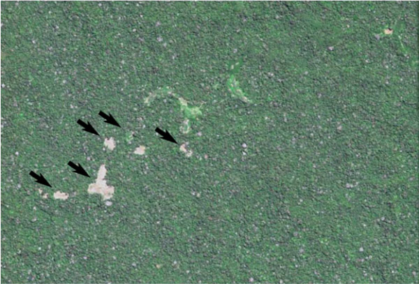 A laundry list of dangers threaten Amazonia’s few remaining uncontacted indigenous communities. Colonists and industry workers often grab tribal land for mining, logging, drug trafficking, or hydrocarbon extraction, which damage the groups’ environment and bring them into conflict with armed settlers. Careless encroachment by outsiders can also bring diseases to which uncontacted groups have no […]
What’s the current deforestation rate in the Amazon rainforest?
- Nearly two-thirds of the Amazon rainforest is located in Brazil, making it the biggest component in the region’s deforestation rate.
- Helpfully, Brazil also has the best systems for tracking deforestation.
- Month-to-month deforestation is highly variable leading to frequent misreporting in the media.
Borneo’s rainforest may get high-tech 3D scan to boost conservation
 CAO lasers easily penetrate forest canopies to reveal minute variations in ground elevation associated with soils. This images shows a ground elevation map in dense tropical forest of western Amazon. The map uncovers a history of geologically old meanders in the Tambopata River in Peru. Today, only the main stem of the river persists, and […]
Deforestation in Brazilian Amazon continues to accelerate
 Deforestation in the Brazilian Amazon — the planet’s largest rainforest — continues to pace well ahead of last year’s rate, reveals data released by Imazon, a Manaus-based nonprofit. According to Imazon’s analysis of satellite data, March 2015 was the eleventh consecutive month that forest loss increased relative to a year earlier. March 2015’s loss of […]
Platform provides near-real time analysis of deforestation in non-Brazilian Amazon
 MAAP image of the week #2: Deforestation by United Cacao for eventual chocolate production in Peru. A new platform will provide critical near-real time information and analysis on emerging threats to forests in the non-Brazilian Amazon. Officially announced today, the Monitoring of the Andean Amazon Project (MAAP) in an initiative launched by the Amazon Conservation […]
Seeing the trees but not the forest (commentary)
 Kenneth MacDicken and Francesco Tubiello work at the Food and Agriculture Organization of the United Nations (FAO). The views expressed in this commentary are their own. Old-growth rainforest in Malaysian Borneo. Photos by Rhett A. Butler Understanding forest dynamics is necessary for the sound management of forests, for both production and conservation. This includes an […]
Brazil confirms rising deforestation in the Amazon
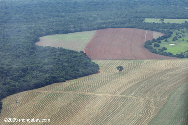 Remnant Brazil nut tree in a landscape cleared for soy fields. Photos by Rhett A. Butler The Brazilian government has officially confirmed that deforestation in the Amazon is pacing sharply higher than a year ago. Figures released last week by the National Institute for Space Research (INPE) shows that forest clearing detected by DETER — […]
Rainforest loss increased in the 2000s, concludes new analysis
 Click charts to enlarge Loss of tropical forests accelerated roughly 60 percent during the 2000s, argues a paper published in the journal Geophysical Research Letters. The findings contradict previous research suggesting that deforestation slowed since the 1990s. The study is based on a map of 1990 forest cover developed last year by Do-Hyung Kim and […]
New Guinea rainforest being leveled for palm oil, revealing gaps in zero deforestation pacts
 Greenomics map showing recent clearing by Austindo Nusantara Jaya Agri in West Papua, Indonesia An Indonesian palm oil firm is destroying rainforests in New Guinea despite high profile zero deforestation pledges from its customers, finds research by Greenomics-Indonesia. Landsat imagery acquired and analyzed by Greenomics shows that Austindo Nusantara Jaya Agri (ANJ) is clearing high […]
Drones to scan the Amazon rainforest for hidden civilizations
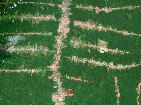 Modern day signs of human activity in the Amazon rainforest. Courtesy of NASA. Click to enlarge. Researchers are planning to use drones equipped with vegetation-penetrating lasers to scan the Amazon rainforest for signs of past civilizations, reports the University of Exeter. A team led by Exeter archaeologist José Iriarte hopes the initiative will help settle […]
Feeds: news | india | latam | brasil | indonesia