Sites: news | india | latam | brasil | indonesia
Feeds: news | india | latam | brasil | indonesia
topic: Mobile
Social media activity version | Lean version
In Madagascar, revived environmental crime hotline leads to tortoise bust
- A Malagasy civil society group recently relaunched a hotline for people to report environmental crimes while avoiding the reprisals that often follow when they make such reports to the authorities.
- The group hired four environmental lawyers to answer the phones and investigate the cases, referring some to government agencies for enforcement.
- An anonymous caller told hotline lawyers about a classified ad for endangered tortoises in a Malagasy newspaper. The call led to the arrest in March of the seller, a government worker who is now in prison awaiting trial.
- Many governments have online and telephone reporting options for environmental and wildlife crimes. However, in countries with corrupt institutions and weak law enforcement, NGOs and civil society groups often run the hotlines.
Tree-planting programs turn to tech solutions to track effectiveness
- Governments and organizations around the world have carried out massive tree-planting initiatives, but to date there’s been no reliable way to track how effective these programs have been.
- Now, some groups are embracing cutting-edge technology solutions such as QR codes, drone surveillance and blockchain to keep tabs on every tree planted.
- But they also recognize the importance of bringing local communities on board to improve the effectiveness of these efforts, and the need for old-fashioned field surveys to complement the high-tech monitoring methods.
Reducing human-elephant encounters with calls, texts, and digital signs
- The Hassan district of Karnataka, India has been a hotbed of human-elephant encounters for years and a challenge for forest authorities, who have been translocating crop-raiding elephants for decades.
- Researchers have replicated an elephant alert system that combines signs, voice calls, and text messaging used in the elephant corridors of neighboring Tamil Nadu’s Valparai region to reduce negative interactions between people and elephants in Hassan.
- Using familiar technologies, the new system has reduced annual human fatalities in the region from several to nearly zero.
Photos highlight evolving roles of AI, citizen science in species research
- A recent observation by an amateur naturalist of a fiddler crab species hundreds of kilometers north of its known range challenged the complementary strengths of computer vision and human expertise in mapping species distributions.
- The naturalist uploaded this record to the iNaturalist species database used by amateurs and experts to document sightings; expert input correctly identified the specimen after the platform’s computer vision algorithms did not acknowledge the species outside its documented range.
- Citizen naturalist observations can be used to document rapid changes in species distributions. They also can improve modeling and mapping work conducted by researchers and play an increasing prominent role in building environmental databases.
Hackathon enlightens coders and conservationists alike
- In late October, 125 computer science students from across the United States gathered at JPMorgan Chase’s Jersey City office for the Code for Good hackathon.
- At this competition, a panel of environmental non-profits presented issues, such as promoting sustainable behavior and tracking park visitor patterns, as prompts for teams of students to construct digital prototypes.
- Creating software to address resource use and conservation challenges can both inspire computer engineers to engage in social and environmental activism and provide instrumental products for conservation.
Machine-learning app to fight invasive crop pest in Africa
- To monitor the invasive fall armyworm caterpillar in Africa, the UN’s Food and Agriculture Organization and Pennsylvania State University have collaborated on an AI add-on to FAO’s existing phone app to help farmers detect agricultural pests.
- The fall armyworm, an invasive pest of over 80 plant species, is native to the Americas but reached Africa in early 2016 and has wreaked havoc on their maize, threatening food security.
- The add-on, called Nuru, identifies leaf damage in photos taken by farmers and sends information to authorities to help monitor the presence of the pest.
- Detecting the pest quickly can help reduce unnecessary pesticide use that can damage human and ecosystem health.
The iNaturalist species data sharing platform reaches one million users
- The iNaturalist species data-sharing platform reached a milestone earlier this month with its one millionth observer.
- The 10-year-old platform and mobile app use several smartphone technologies, crowd-sourced data, and artificial intelligence to help observers identify the species of plants and animals they see.
- Co-founder Scott Loarie highlighted the rapid progress in computer vision technology as a surprisingly helpful technology that complements crowdsourcing to speed the image identification process for a large number of photos, though it has also introduced other concerns, including how to maintain high data quality.
For an Amazon tribe, phone cameras shine a light on their wildlife
- Armed with smartphone cameras, teams of indigenous Matsés people have partnered with North American herpetologists to inventory the reptiles and amphibians of their territory along the remote divide between Peru and Brazil.
- The easy-to-use cameras are robust, small enough to carry while climbing a tree or crossing a stream, store thousands of images, and can be recharged with low-cost solar panels.
- The teams have built a database of more than 2,000 photos, including several new species, and they have expanded the known distributions of other species.
- The long-term project complements rapid ecological assessments of a poorly studied region and empowers Matsés elders to pass on their knowledge of the region’s forests to both their families and the outside world.
Tech goes back to basics to mitigate human-wildlife conflict near Indian parks
- A simple user-friendly mobile phone system has helped villagers near two Indian national parks report crop and livestock damages to authorities and receive appropriate compensation.
- Such damages can lead to retaliatory killing ofanimals, whereas compensation can help foster tolerance of wildlife even in densely populated regions.
- The mobile technology used by the Wild Seve project speeds the compensation processes using a toll-free hotline that records the victim’s voice message with details of the incident and routes it to a field coordinator, who sends local trained responders to meet with the complainant within 24 hours.
‘Better and better’: Thermal cameras turn up the heat on poachers
- The annual Serengeti-Maasai Mara wildebeest migration attracts not just tourists, but also bushmeat poachers, who kill between 40,000 and 100,000 animals along the way.
- In 2016, the Mara Conservancy began using FLIR thermal cameras, which detect heat instead of light, to find and capture poachers at night, when they are most active.
- Thermal imaging, together with a motivated team using high-quality digital radios, has led to the capture of over 100 people and left poachers at a loss as to how they’re being detected.
Smartphone app helps indigenous communities fight deforestation
- Using a system called ForestLink developed by Rainforest Foundation UK, members of the Masenawa community documented the presence of an illegal gold mining camp in the Madre de Dios region of Peru.
- The police then responded by destroying the mining equipment at the camp and arresting five people suspected of participating in illegal mining.
- The biodiverse Madre de Dios region of the Amazon has been besieged by illegal gold mining, which has caused widespread deforestation.
Mongabay discusses technology’s role in conservation at Seattle event [VIDEO]
- A team from Mongabay discussed new applications of technology for conservation with representatives of Seattle Audubon and Acate Amazon Conservation during an event at Seattle Central College, Washington.
- In this video recording, the panelists discuss topics ranging from bioacoustics to remote sensing and AI and answer questions from the audience.
Kenyan reserve’s tourism monitoring app builds revenue and transparency
- Wardens at Kenya’s Mara Conservancy solved a revenue loss problem by teaming up with their revenue management company to create a smartphone app that lets them check tourists’ ticket and payment status by entering the vehicle license plate numbers.
- Obtaining up-to-date information about the tourists and the validity of their ticket from their patrol car saves the rangers time and avoids their having to interrupt a group’s safari.
- The rangers address any discrepancies first with the tour guide and involve tourists only as a last resort, which has nearly eliminated cheating and enabled the Reserve to boost the revenue it retains.
Cities worldwide use photo app technology to compete in nature observation challenge
- The third-annual City Nature Challenge takes place this weekend, April 27-30, 2018, giving nature lovers in cities around the globe a chance to compete against other cities to see who can make the most observations and find the most species of local plants and animals.
- Residents and visitors from nearly 70 cities will use their smartphones and the iNaturalist app to share photos of their findings over the 4-day period; experts will verify the identifications in early May.
- Organizers hope the event will connect more people to their local urban biodiversity and uncover threatened and invasive species in new locations, to assist local resource managers.
You don’t need a bigger boat: AI buoys safeguard swimmers and sharks
- A new tech-driven device may help reduce harmful interactions with sharks and improve people’s tolerance of one of the ocean’s top predators.
- The system, called Clever Buoy, combines sonar to detect a large object in the water, artificial intelligence to determine that the object is a shark close enough to threaten beachgoers, and automated SMS alerts to lifeguards that enable them to take action.
- Local governments have deployed the system at popular beaches and surfing sites to test its capacity to protect swimmers and surfers without harming marine wildlife.
How to build a Guardian: students learn about making technology work in the field
- Students in several science and tech schools in California are learning to design and build Guardians, acoustic monitoring devices to help protect rainforests from illegal logging while keeping a record of the sounds made by forest wildlife.
- Led by the non-profit Rainforest Connection, the students are constructing the Guardians from old, recycled smartphones armed with solar power and Google’s open source machine learning framework, TensorFlow, which transforms them into field-tough listening tools.
- The program also addresses the challenges of designing and developing technology for humid, rugged, remote field conditions typical of indigenous reserves and protected areas.
Crowdsourcing the fight against poaching, with the help of remote cameras
- A U.S. non-profit and a cadre of volunteers have teamed up with reserves in South Africa and Indonesia to combat wildlife poaching through a series of connected camera traps.
- The group’s monitoring system, wpsWatch, can transmit visual, infrared, and thermal camera images as well as data from radar, motion detectors, and other field devices.
- The volunteers monitor image feeds while rangers sleep and have become an effective part of the team, which has detected roughly 180 intrusions into the reserves, including rhino and bushmeat poachers.
10 top conservation tech innovations from 2017
- The increased portability and reduced cost of data collection and synthesis tools have transformed how we research and conserve the natural world.
- Devices from visual and acoustic sensors to DNA sequencers help us better understand the world around us, and they combine with online mapping platforms to help us monitor it.
- New online and mobile apps have democratized data collection, inspiring a brave new world of citizen scientists to learn about the species around them, contribute to conservation and scientific discovery, and feel part of a learning community.
- Here, we present 10 tech trends we covered in 2017, in no particular order, that have helped us better understand nature, monitor its status, and take action to protect it.
Counting tigers on smartphones
- India’s 2018 national tiger estimation will use an Android-based mobile application to streamline collection of field data on tigers and prey, add photos and GPS coordinates, record poaching and human-wildlife conflict, and reduce error in data entry.
- The M-STrIPES app uploads field data automatically to a remote central server for rapid analysis or stores the data on the user’s mobile phone until internet access is available.
- The app has been tested successfully in a few tiger reserves, made more user friendly, and is now being rolled out on a national scale, but can it help resolve discrepancies in survey results?
SMART and well-Connected: reserve patrol data system adds communications capacity
- The SMART software helps protected area rangers and managers report, analyze, and manage field data to target their patrolling and management activities.
- A new extension to SMART allows a user to centrally manage data uploaded from multiple sites and syncs changes made from various users of a database.
- SMART Connect wirelessly communicates field observation data from rangers on patrol to managers and colleagues watching remotely; instantaneous data transmission to the central server requires rangers have coverage by wifi or a cellular network.
Citizen scientists use mobile apps to help “green” the ocean
- Marine debris litters beaches and underwater habitats across the globe, even in remote areas, where it harms hundreds of animal species, from corals to whales.
- Mobile phone apps have launched to encourage and assist volunteers in cleaning up marine habitats by facilitating the recording and sharing of their efforts via social media.
- Volunteers also become citizen scientists, as the apps compile data from thousands of clean-ups into global databases to permit analysis of trends in trash composition and distribution and to bring to light the damage being done by debris to marine creatures and systems.
App combines computer vision and crowdsourcing to explore Earth’s biodiversity, one photo at a time
- The nearly 500,000 users in the iNaturalist network have uploaded over 6.5 million photo observations of more than 120,000 species of plants, animals, insects and fungi.
- The network provides a platform for collaboration and discussion among users, while also generating a stream of research quality biodiversity data.
- A recent update to the smartphone app utilizes computer vision to provide immediate taxonomic identifications for user-submitted photos, with varying degrees of specificity.
- The computer vision network requires a large database of identified images to learn the distinctive features of each species; every photo observation uploaded to iNaturalist and identified by the community helps to improve the coverage and accuracy of the automatic identification feature.
Low-tech challenges to high-tech forest monitoring: lessons from Ugandan parks
- Remote sensing technology can provide useful intelligence to park managers but must be combined with an understanding of its limitations, as well as the tools and training needed for its use.
- An assessment by park rangers in Uganda of satellite image-based deforestation alerts found that the alert locations at 30 m x 30 m resolution were sufficiently accurate to support reserve management.
- The near real-time alerts of likely deforestation could make forest patrols more efficient and effective, but rangers must still have proper training, incentives, and resources to properly integrate alerts into their regular functions.
Tuna catch monitoring enters the electronic age
- A new electronic monitoring system is being tested in the western and central Pacific to improve the timeliness and accuracy of tuna catch data and the transparency of tuna supply chains through faster more effective on-board and portside catch monitoring.
- Illegal, Unreported, and Unregulated (IUU) fishing results in overharvesting and an annual loss of US $600 million for the region and is perpetrated primarily by licensed vessels hauling in unreported and unregulated fish stock.
- The Onboard, Observer, and TAILS portside e-Reporting apps are still in the testing phase, but their use is expected to expand across the Pacific.
Catching the buzz: acoustic monitoring of bees could determine pollination services
- The services of pollinating animals are necessary for the reproduction of over 85 percent of flowering plants, and the majority of these pollinators are bees.
- Characteristics of individual bees, including their body size and tongue length, result in unique buzz signatures and allow for the study of the bee’s productivity.
- To help the productivity of bees’ pollination services, researchers have developed an inexpensive method of measuring each bee’s acoustics that will eventually be available for the public’s use.
Soil research aided by citizen scientists, boots and all
- Researchers in England tested a novel approach to detect pathogens in the environment, combining citizen science and lab analysis.
- They related the presence of Campylobacter bacteria, consistently detected through boot socks worn by volunteers walking outdoors, to environmental variables and probable sources.
- Their findings highlight the potential for using field data collected by citizen scientists to assess the presence and transmission of pathogens and other particles in the environment.
Whistleblowing for wildlife
- The National Whistleblower Center (NWC)’s new Global Wildlife Whistleblower Program is launching a secure website and attorney referral service to help people provide tips on wildlife crime and obtain rewards from whistleblower provisions in relevant laws.
- The program combats wildlife extinction by incentivizing potential whistleblowers to come forward and submit tips confidentially and anonymously.
- To increase the platform’s impact, the NWC is ramping up outreach and hoping to develop an app in 2017 to facilitate mobile reports.
A World of Tings
- Created in 2012, Latest Sightings is a mobile app and social network with a community between 450,000 and 500,000 people.
- Latest Sightings allows app users to report real-time sightings within South African parks and promotes conservation and education through online platforms.
- Wildlife sighting apps have faced recent criticism, but Latest Sightings CEO and Founder Nadav Ossendryver explains that these apps are saving wildlife and globally educating millions of wildlife enthusiasts.
Combining high-tech and low-tech to turn satellite images into action
- Remote sensing is not only a science, it’s also an art. And in order to interpret the imagery, you need a deep understanding of the land you’re studying.
- Satellite images can show us where the forest patches are, but they don’t tell us why. That information comes from communities.
- Information doesn’t automatically transform into a management action, and conservation scientists must learn how to turn scientific information and big data into engaging stories.
Empowering smartphone users to bear witness to illegal wildlife trade
- The Wildlife Witness app allows travelers and locals to anonymously and securely report wildlife trafficking they observe in Southeast Asia.
- As the first app for global community action against illegal wildlife trade, it allows tourists and regional residents to assist wildlife law enforcement and endangered species conservation.
- The app encourages people to use the internet and other avenues to speak up against and learn more about wildlife trafficking and their own role in countering it.
Want to identify that bug or beetle in your photo? Ask the crowd.
- The iSpot web application allows users to post photos of plants and animals and receive crowdsourced help in identifying the species they’ve captured in photos
- The network connects novices with experts and allows users to gain and improve their reputation for familiarity with a group of species.
- The project aims to increase biodiversity knowledge through informal learning and community input while expanding information on species distributions.
Light, long-lasting and low-cost: the technology needs of field conservationists and wildlife researchers
- The concurrent challenges of remoteness, extreme temperatures, dust, high rainfall and humidity, dense vegetation and steep terrain all complicate and limit the use of existing and emerging technologies for nature conservation and research.
- Survey responses of front-line conservationists suggest that no single technology will stop either wildlife poaching or human-wildlife conflict.
- Researchers everywhere desire smaller, lighter, longer-lasting, and more affordable devices that better withstand humidity, dust and damage.
- Integrated, automated devices and systems for detecting, monitoring, and providing early warning of movements of people and animals would revolutionize conservation and research work across species, ecosystems, and countries.
Participatory Mapping in the Mobile Age
- The Kogi people have a unique spiritual and ecological connection with the forests they live in, but the forest is now under threat from gold mining, agriculture, and human development.
- The Amazon Conservation Team is piloting an open-source phone app (ODK) to help the Kogi gather data and create geo-referenced maps of their land
- ACT and the Kogi plan to use the detailed digital maps to protect sacred and ecologically important sites from deforestation, and reclaim traditional land holdings.
CyberTracking for Africa’s most endangered ape
- Protected area staff use the handheld tool CyberTracker to collect data and produce spatial and statistical analyses to guard gorillas in Cross River reserves.
- The system aids the conservation of the critically endangered Cross River gorilla, improving law enforcement by facilitating the monitoring of wildlife, human interferences and patrols.
- CyberTracker use is expanding to other reserves in West Africa and around the globe, both on its own and, in places like the Cross River landscape, in combination with SMART analysis software.
Bringing field surveys into the modern, mobile world
- Open Data Kit, a set of free and open-source survey tools, can integrate GPS locations, photos, videos and audio files into customized forms, while also working off-the-grid.
- Users can transfer data collected in the field from the mobile device to a server and upload to Excel, Google Maps, or more sophisticated statistical analysis software.
- Open Data Kit requires electricity to charge mobile devices, as well as the physical presence of surveyors to conduct the interviews, but its use can simplify data processing.
Just Text It In: Streamline Survey Collection through SMS
- Mobile surveys are becoming ubiquitous in the 21st century, with findings showing they save both time and money over traditional paper surveys.
- The TextIt service helps you build and distribute conversational surveys soley through SMS.
- Establishing more consistent communication and providing valuable information to rural communities over SMS can aid practitioners looking to involve local people in conservation efforts.
goTenna provides low-cost remote communication without a cell network
- Rangers, hikers, and researchers all need to communicate in the field, though mobile coverage is poor or absent in many remote areas.
- The goTenna device connects via Bluetooth to a smartphone, and via long-range radio to one or more other goTennas to provide instantaneous SMS communication between the devices.
- Still on pre-order, goTenna tests indicate local (2-6 km) communication in forest and a longer range if devices can be elevated.
Staying connected: the (unequal) global distribution of Internet devices
- Lack of internet access limits economic development, rapid and effective communication, and the ability of people to put their local situation in a broader context.
- Globally, a country’s percentage of internet users ranges widely, from 1.2% in Myanmar to 96.5% in Iceland, whereas mobile phones are common everywhere, even in the poorest countries.
- With their escalation in both number and capability, mobile phones may become an alternative medium for many new data collection and communication innovations.
Scientists build app to automatically identify species based on their calls
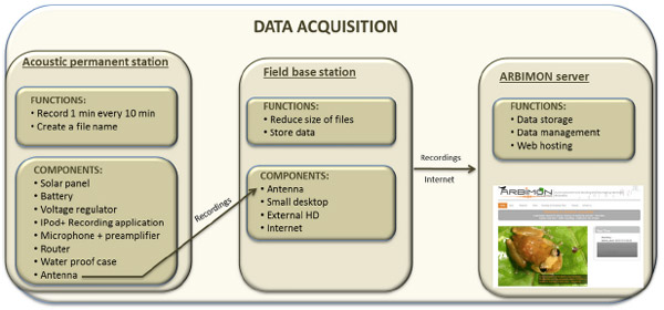 Call recognition for animals. New technology makes it possible to automatically identify species by their vocalizations. The software and hardware system, detailed in the current issue of the journal PeerJ, has been used at sites in Puerto Rico and Costa Rica to identify frogs, insects, birds, and monkeys. Many of the animals identified by the […]
Feeds: news | india | latam | brasil | indonesia