Sites: news | india | latam | brasil | indonesia
Feeds: news | india | latam | brasil | indonesia
topic: data
Social media activity version | Lean version
Tropical forest loss puts 2030 zero-deforestation target further out of reach
- The overall rate of primary forest loss across the tropics remained stubbornly high in 2023, putting the world well off track from its net-zero deforestation target by 2030, according to a new report from the World Resources Institute.
- The few bright spots were Brazil and Colombia, where changes in political leadership helped drive down deforestation rates in the Amazon.
- Elsewhere, however, several countries hit record-high rates of forest loss, including the Democratic Republic of Congo, Bolivia and Laos, driven largely by agriculture, mining and fires.
- The report authors call for “bold global mechanisms and unique local initiatives … to achieve enduring reductions in deforestation across all tropical front countries.”
Critics fear catastrophic energy crisis as AI is outsourced to Latin America
- AI use is surging astronomically around the globe, requiring vastly more energy to make AI-friendly semiconductor chips and causing a gigantic explosion in data center construction. So large and rapid is this expansion that Sam Altman, the boss of OpenAI, has warned that AI is driving humanity toward a “catastrophic energy crisis.”
- Altman’s solution is an audacious plan to spend up to $7 trillion to produce energy from nuclear fusion. But even if this investment, the biggest in all of history, occurred, its impact wouldn’t be felt until mid-century, and do little to end the energy and water crises triggered by AI manufacture and use, while having huge mining and toxic waste impacts.
- Data centers are mushrooming worldwide to meet AI demand, but particularly in Latin America, seen as strategically located by Big Tech. One of the largest data center hubs is in Querétaro, a Mexican state with high risk of intensifying climate change-induced drought. Farmers are already protesting their risk of losing water access.
- As Latin American protests rise over the environmental and social harm done by AI, activists and academics are calling for a halt to government rubber-stamping of approvals for new data centers, for a full assessment of AI life-cycle impacts, and for new regulations to curb the growing social harm caused by AI.
‘We’re doing so much with so little’: Interview with WildLabs’ Talia Speaker
- The use of technology for conservation and wildlife monitoring increased in recent years, with camera traps and remote sensing being the most popular tools, a report has found.
- The report by conservation technology network WildLabs also found that artificial intelligence was highly ranked for its potential impact, but was ranked low in terms of current performance because of accessibility issues.
- Marginalized groups, including women and people from lower-income countries, were found to face disproportionate barriers to accessing resources and training.
- “The motivation behind this research was to capture the experiences of the global conservation technology community, and to speak with a united voice,” says Talia Speaker, who led the research.
Indonesian utility PLN ordered to disclose coal plants’ emissions data
- Indonesia’s Public Information Commission (KIP) has ordered state-owned utility PLN to disclose emissions data for some of the country’s biggest coal-fired power plants.
- Civil society groups have hailed the decision as a victory against government opacity and a major step toward accountability for public health.
- The KIP’s decision isn’t the end of the story, however; there’s a long history of various government ministries simply refusing to comply with its orders for data disclosure, and it’s not clear whether PLN will buck that trend.
AI and satellite data map true scale of untracked fishing and ocean industry
- A new study shows that more than 75% of industrial fishing activity and almost 30% of transport and energy activity in the oceans has not been tracked by public systems, revealing a significant gap in global observational data.
- The study, led by Global Fishing Watch, used AI to analyze 2 petabytes of satellite imagery collected between 2017 and 2021, providing unprecedented insights into hidden fishing hotspots and offshore energy infrastructure development.
- The research highlighted the potential of combining AI with Earth observation data to gain a more comprehensive understanding of ocean activities, which is needed to manage and improve the sustainability of the $2.5 trillion blue economy.
- The open-source code developed during the study can help inform policy for safeguarding ocean ecosystems, enforcing laws and identifying renewable energy expansion sites, the study authors said.
Conservation X Labs announces merger with AI nonprofit Wild Me
- Conservation technology company Conservation X Labs has announced a merger with Wild Me, a nonprofit that focuses on using artificial intelligence for conservation purposes.
- The two organizations plan to combine their resources and expertise to ramp up the use of artificial intelligence to prevent the sixth mass extinction.
- The merger comes at a time when AI’s role in biodiversity monitoring and conservation has seen rising popularity.
- According to a press statement by Conservation X Labs, the company will “integrate Wild Me’s technology into its product offerings.”
‘No end in sight’ for potential of conservation tech: Q&A with Megan Owen
- For the past seven years, the conservation technology lab at the San Diego Zoo Wildlife Alliance has been working to develop and deploy technology that can automate the collection and processing of wildlife data.
- Running a tech lab in a zoo has the benefit of providing scientists with a setting where they can use the wildlife in their care to validate the data and calibrate the technology.
- Team members at the lab are also working to develop and mentor the next generation of conservation technologists who can keep up with the rapidly evolving field.
- Making the technology “low-cost and accessible, fixable, deployable and programmable” continue to be some of the challenges that the team is working to overcome, according to SDZWA vice president of conservation science Megan Owen.
Detailed NASA analysis finds Earth and Amazon in deep climate trouble
- A NASA study analyzed the future action of six climate variables in all the world’s regions — air temperature, precipitation, relative humidity, short- and long wave solar radiation and wind speed — if Earth’s average temperature reaches 2° Celsius (3.6° Fahrenheit) above preindustrial levels, which could occur by 2040 if emissions keep rising at current rates.
- The authors used advanced statistical techniques to downscale climate models at a resolution eight times greater than most previous models. This allows for identification of climate variations on a daily basis across the world, something essential since climate impacts unfold gradually, rather than as upheavals.
- The study found that the Amazon will be the area with the greatest reduction in relative humidity. An analysis by the Brazilian space agency INPE showed that some parts of this rainforest biome have already reached maximum temperatures of more than 3°C (5.4°F) over 1960 levels.
- Regardless of warnings from science and Indigenous peoples of the existential threat posed by climate change, the world’s largest fossil fuel producers, largely with government consent, plan to further expand fossil fuel exploration, says a U.N. report. That’s despite a COP28 climate summit deal “transitioning away from fossil fuels.”
New platform offers toolkit for companies to prove their eco claims
- As governments around the world consider new regulations that would require corporations to track their impacts on biodiversity, a new platform called NatureHelm provides companies and individual landowners with a tool to track indicators of ecosystem health.
- The tool analyzes various databases and scientific papers to find relevant local biodiversity targets and automatically pulls in data from remote tools, such as camera traps, to track them.
- NatureHelm also provides consulting to help companies choose the best tools to track biodiversity targets, and produces annual reports that allow companies to show how different metrics change over time and in response to conservation actions.
New AI model gives bird’s-eye view of avian distribution at vast scale
- An artificial intelligence model is helping researchers use bird-sighting data to estimate their presence at a given time and location.
- Developed by researchers at Cornell University, the model makes predictions on when and where species of birds in North America might occur throughout the year, providing information that could be vital for conservation purposes.
- The model was trained using billions of data points from eBird, an online portal and database where birders can record the observations they make in the field.
- The researchers are now working to train the model to get estimates on abundance of species as opposed to only getting information on their presence or absence.
Betting on biodiversity: Q&A with Superorganism’s Kevin Webb & Tom Quigley
- Superorganism is a newly launched venture capital firm, touted to be the first that’s dedicated to addressing the biodiversity crisis.
- The firm aims to support startups that are developing and deploying technology to prevent biodiversity loss and protect nature.
- The firm’s early portfolio includes companies that are working to tackle extinction drivers and finding solutions that lay at the intersection of biodiversity conservation and climate change mitigation.
The Cloud vs. drought: Water hog data centers threaten Latin America, critics say
- Droughts in Uruguay and Chile have led residents to question the wisdom of their governments allowing transnational internet technology companies to build water-hungry mega-data centers there.
- As servers process data, they need lot of water to keep them cool. But if demand grows as expected, the world will need 10-20 times more data centers by 2035, and they’ll be using far more water. Many will likely be built in economically and water-challenged nations already facing climate change-intensified droughts.
- Latin American communities fear that this “data colonialism” will consume water they desperately need for drinking and agriculture, and are critical of their governments for giving priority treatment to transnational tech giants like Google and Microsoft, while putting people’s access to a basic human necessity at risk.
- Surging digital data use by 2030 may cause each of us in the developed world to have a “digital doppelganger,” with our internet use consuming as much water as our physical bodies. But much of the stored data is “junk.” Critics urge that nations insist on tougher regulations for transnational companies, easing the crisis.
Taking the global pulse of biodiversity monitoring: Q&A with Andrew Gonzalez
- A group of scientists have put forward a proposal to set up a global network that centralizes biodiversity monitoring and facilitates seamless sharing of data.
- The group wants its proposed Global Biodiversity Observing System (GBiOS) to function similarly to the network of local weather monitoring stations across the world, whose data are used to analyze and monitor climate change.
- While the technology being used to monitor biodiversity has become more sophisticated over the years, there still exists a void in getting different communities to work together to address the broader challenges in dealing with the biodiversity crisis.
- “We would not only federate people who are working together more effectively, but also fill many of the gaps in the data that currently exist in the biodiversity field,” Andrew Gonzalez, who is leading the proposal for GBiOS, told Mongabay.
New Tree Tech: Real-time, long-term, high-tech reforestation monitoring
- This four-part Mongabay mini-series examines the latest technological solutions to help tree-planting projects achieve scale and long-term efficiency. Using these innovative approaches could be vital for meeting international targets to repair degraded ecosystems, sequester carbon, and restore biodiversity.
- Many people see reforestation as a quick fix to the climate emergency, but tree-planting projects often fail to put in place the monitoring programs needed to track newly planted forests. Traditionally, forest monitoring has been done by hand, one tree at a time, which is extremely expensive and time-consuming.
- Satellites are mapping and remapping the entire planet daily, providing real-time data that can be used to monitor forests remotely. Drones can fly over or through forests to collect data on tree growth, bridging the gap between on-site measurements and distant satellites.
- Sensors can be installed to monitor individual trees directly, while people can collect and analyze the data electronically from a safer and easier-to-access location. Multiple sensors can form a distributed network that returns detailed information on the growth of each tree within huge reforestation plots.
New Tree Tech: Data-driven reforestation methods match trees to habitats
- This four-part Mongabay mini-series examines the latest technological solutions to help tree-planting projects achieve scale and long-term efficiency. Using these innovative approaches could be vital for meeting international targets to repair degraded ecosystems, sequester carbon, and restore biodiversity.
- To create healthy, diverse ecosystems, native tree species need to be identified that will thrive at each unique site within a habitat. But with more than 70,000 tree species worldwide, gathering and analyzing the data needed to understand species’ needs, habitat preferences and limitations is no small feat.
- Environmental niche models use data on climate, soil conditions and other characteristics within a species’ range to calculate a tree’s requirements. Artificial intelligence helps sort through vast data sets to make informed predictions about the species suited to an ecosystem, now and in a warmer future.
- Biotechnology company Spades uses laboratory testing of tissue samples from plant species to quantify what growing conditions a species can tolerate and to identify its optimum growing conditions.
Feathered forecast: Tech tools comb weather data for bird migrations
- Since its launch in 1999, the BirdCast project has used weather radar data to track and forecast bird migrations across the U.S.
- In recent years, technology such as cloud computing and machine learning have helped make the work of researchers in the project easier and more automated.
- Studying bird migrations is essential not only to help protect them, but to also analyze and understand environmental health.
- The BirdCast project is now working on integrating radar data with human observations and bioacoustics to help identify the bird species traversing the skies.
Agulhas Current enigma: An oceanic gap in our climate understanding
- Comprehending the workings of western boundary ocean currents, like those of the Agulhas Current off the South African coast, may hold a key to Earth’s climate system. But understanding this particular current is hampered by a major lack of in-situ data. This gap leaves us in the dark about local, regional and global climate impacts.
- The Agulhas Current, located in the Indian Ocean, is one of the most energetic ocean current systems in the world. Changes to it can impact local weather in South Africa and elsewhere in the Southern Hemisphere, and perhaps influence large-scale climatic changes in the Northern Hemisphere and globally as well.
- However, it is not clear how and what these impacts may be, or when they may occur. With climate change escalating rapidly due to unabated human carbon emissions, it is now more important than ever that we understand the impacts of Southern Hemisphere ocean currents, and integrate their actions into climate models.
- But attempts at long-term monitoring of the Agulhas Current System have not been fully successful. Accomplishments and failures to date have underscored significant local research capacity challenges, and differences in the approach to, and financing of, ocean science in the Global North as compared to the Global South.
In Gabon, camera-trap developers find the ideal proving ground for their craft
- Rich in forests and biodiversity, the Central African country of Gabon has long proved a fruitful testing ground for camera-trap technology.
- Snapshots of species once thought extinct in the country, such as lions, have helped inform conservation policy, including the establishment of national parks and protection of vast swaths of forest.
- The wealth of data generated means there are large data sets from various projects that researchers just don’t have the resources or time to sift through — which is why Gabon has also become a testing ground for artificial intelligence tools to aid in that task.
- Key limitations remain the cost of camera traps and the fact that many forms of data capture and analysis simply can’t be done by camera traps or AI, and still require human involvement.
Photos: Meet the Indonesians on the front lines of human-elephant conflict in Sumatra
- At the northern tip of Sumatra, villagers deal with herds of elephants entering their villages and eating their crops.
- Incidents of human-wildlife conflict have intensified as more of the elephants’ habitat is razed for oil palm plantations and other developments.
- In the village of Cot Girek, locals have formed their own patrol team to head off these incursions.
‘Chased from every side’: Sumatran elephants pinned down by forest loss
- Sumatran elephants in Indonesia’s North Aceh district are being increasingly pinned down in shrinking patches of forest amid the ongoing destruction of their habitat, primarily for oil palm plantations.
- This is driving an increase in human-elephant conflict, with the animals forced into more frequent encounters with villagers, who resent them for destroying their crops and homes.
- Conservationists say deforestation in the district overlaps with the elephants’ migration routes and could grow worse under local government policies.
Saving Sumatran elephants starts with counting them. Indonesia won’t say how many are left
- Efforts to save the Sumatran elephant have been hamstrung by the Indonesian government’s delay in releasing an updated conservation plan, which includes the latest population estimates.
- The last estimate, from 2007, put the population at 2,400-2,800 elephants, but that was based on data from the early 2000s.
- Mongabay has obtained a copy of the updated plan, meant to be released in 2019, which gives a population estimate of 924-1,359 — a precipitous decline of 52-62% from the 2007 figure.
- Conservationists, including one who worked on the plan, have called for its publication to inform conservation measures, and note that similar plans for other iconic threatened species — including Sumatran tigers and orangutans — have also been delayed.
Brazil’s new deforestation data board sparks fear of censorship of forest loss, fires
- A new council set by the Brazilian government to vet deforestation and forest fire data from the country’s space agency has been widely slammed as a political ploy to aid President Jair Bolsonaro’s reelection bid.
- The National Institute of Space Research (INPE) has provided and analyzed deforestation and forest fire data in the Amazon since 1988 and is globally renowned for its monitoring expertise, but was left out of the new council.
- The Bolsonaro government has questioned the credibility of INPE’s data since taking office in 2019, drawing outrage from scientists and researchers for claiming that data showing a spike in deforestation under Bolsonaro was false.
- Experts have raise concerns that the new council could prevent the release of annual deforestation data, scheduled at the same time as this year’s elections, that are expected to show an alarming increase in both forest loss and fires.
That ‘killer’ spider story you read online? Fake news, most probably
- Media coverage of human encounters with spiders is rife with misinformation, according to a study by more than 60 scientists around the world.
- They compiled a database of more than 5,300 news articles from 81 countries about these encounters, and found 47% had factual errors and 43% were sensationalistic.
- They also found stories that quoted spider experts tended to be more accurate than those that quoted medical experts of pest control specialists, who don’t receive the same level of training.
- Negative media portrayals of spiders, snakes and other animals that many people tend to dislike hurt efforts to conserve species that play an important role in the ecosystem, the study authors say.
Researchers compile largest-ever photo database of Amazon wildlife
- Researchers have compiled more than 154,000 records of camera trap images form the Amazon Rainforest, recording 317 species of birds, mammals and reptiles.
- This is the first study to compile and standardize camera trap images from across the Amazon at this scale, and covers Brazil, Bolivia, Colombia, Ecuador, French Guiana, Peru, Suriname and Venezuela.
- The authors say this camera trap data set opens up opportunities for new studies on forest fragmentation, habitat loss, climate change, and the human-caused loss of animals “in one of the most important and threatened tropical environments in the world.”
2021 tropical forest loss figures put zero-deforestation goal by 2030 out of reach
- The world lost a Cuba-sized area of tropical forest in 2021, putting it far off track from meeting the no-deforestation goal by 2030 that governments and companies committed to at last year’s COP26 climate summit.
- Deforestation rates remained persistently high in Brazil and the Democratic Republic of Congo, home to the world’s two biggest expanses of tropical forest, negating the decline in deforestation seen in places like Indonesia and Gabon.
- The diverging trends in the different countries show that “it’s the domestic politics of forests that often really make a key difference,” says leading forest governance expert Frances Seymour.
- The boreal forests of Eurasia and North America also experienced a spike in deforestation last year, driven mainly by massive fires in Russia, which could set off a feedback loop of more heating and more burning.
Scientists’ secret weapon to monitor the Southern Ocean? Elephant seals
- Southern elephant seals living on Kerguelen Island, a sub-Antarctic island, are helping to gather information about the Southern Ocean with data-logging devices attached to their hair.
- For instance, the elephant seals have helped gather data on sea ice formation, ocean and ice shelf interactions, and frontal system dynamics.
- The Southern Ocean provides many ecosystem services for the planet, but the region is rapidly changing due to climate change.
As its end looms, Cerrado tracker records 6-year deforestation high
- The satellite-based deforestation-monitoring program focused on Brazil’s vast Cerrado savanna may end in April because of lack of funding, with some members of the team reportedly already laid off.
- Unlike the monitoring program for the Amazon, the one for the Cerrado isn’t included in the government budget and relies on external financing, which dried up in August 2020; since then, the program team has had to scrounge for funding from other projects and institutions.
- Sharing the scientists’ concerns is the agribusiness sector, which relies on the data to prove that its commodity is deforestation-free, and which has blasted the government’s “blurred” vision with regard to failing to fund the monitoring program.
- News of the impending closure of the monitoring program comes a week after its latest data release showed an area six times the size of the city of São Paulo was cleared between August 2020 and July 2021 — the highest deforestation rate in the Cerrado since 2015.
Cattle boom in Brazil’s Acre spells doom for Amazon rainforest, activists warn
- Government data show the number of cattle in Acre, a state in the Brazilian Amazon, increased by 8.3% in 2020, putting the state’s herd size at more than 3.8 million, or four times its human population.
- The cattle industry is a key driver of Acre’s economy, and aligns with the state’s aims of promoting and expanding agricultural development within the region.
- However, activists say they’re concerned the increase will lead to further environmental damage in the state, which this year recorded its highest deforestation rate in 18 years.
- Experts say Acre’s cattle growth is currently not sustainable and will lead to further deforestation in the Amazon unless sustainable solutions are encouraged and implemented.
For South Africa’s dwindling renosterveld, there’s now a ‘panic button’ app
- The renosterveld shrubland once covered the Swartland and Overberg regions of western South Africa, but its rich soils led farmers to clear it for agriculture.
- Remaining fragments continue to provide habitat for birds like endangered black harriers and vulnerable southern black korhaans, and mammals like the grey rhebok, a near-threatened antelope.
- A “panic button” app has been developed in South Africa to alert the authorities to threats facing the renosterveld, the country’s most endangered ecosystem.
In Peru’s Amazon, deforestation and crime sweep through Indigenous communities
- Mongabay Latam investigated the territorial security of Indigenous communities in five regions of the Peruvian Amazon: Loreto, Ucayali, Pasco, Huánuco, and Madre de Dios.
- A geospatial analysis of deforestation, illegal mining, and illicit coca crops in these five regions shows that 1,247 Indigenous communities have been affected.
- The study also revealed that 647 self-identified Indigenous communities in these five regions do not have official recognition from regional authorities to certify their existence and therefore obtain legal title to the land.
More than 250 major fires detected in the Amazon this year, despite Brazil’s ban
- There have been 267 major fires detected in the Amazon this year, burning more than 105,000 hectares (260,000 acres) — an area roughly the size of Los Angeles, California.
- More than 75% of these fires blazed in the Brazilian Amazon, in areas where trees have been cut to make way for agriculture, despite a June 27 ban on unauthorized outdoor fires by the Brazilian government.
- The first forest fires of the season have also been detected, those that have escaped pastures and burned standing Amazon rainforest, where fires are not historically naturally occurring.
- A historic drought, rampant deforestation, and lax environmental regulations mean this year is likely to be a bad year for fires, experts say.
How to make conservation more effective: Q&A with Nick Salafsky
- The multifaceted nature of most conservation projects means that many factors need to be monitored and evaluated using a range of metrics to determine whether a real impact has been achieved and can be sustained into the future.
- One of the organizations at the forefront of efforts to measure impact in conservation over the past twenty years has been Foundations of Success, which developed its roots in the 1990s out of a need to develop ways to gauge the success of U.S. government-funded conservation projects.
- From his position as the co-founder and Executive Director of Foundations of Success, Nick Salafsky has seen firsthand how organizations and institutions are responding to the growing preponderance of data and the emergence of new technologies and tools in the conservation space. He says that an organization’s receptiveness to change when more effective pathways are identified is important to achieving conservation success.
- “Perhaps the most important predictor of success is the attitude of the people in an organization – whether they are ultimately interested in merely perpetuating their programs and their jobs versus being open and willing to critically examine and learn from their work,“ he told Mongabay’s founder Rhett A. Butler in a recent interview.
Fire season intensifies in the Brazilian Amazon, feeding off deforestation
- Twenty-four major fires have burned in the Brazilian Amazon so far this year, all of them set on land previously deforested in 2020, until this week when the first major blaze was set on land cleared in 2021.
- Experts are expecting this to be a bad year for fires, owing to a historic drought, high levels of deforestation, and a lack of funding for environmental law enforcement.
- President Jair Bolsonaro signed a decree on June 23 to send Brazilian soldiers into the Amazon to curb deforestation (which often precedes fires), but one expert calls this a “smokescreen” that would allow deforestation to continue.
- Deforestation rates have been higher under Bolsonaro than any past president: in 2020, Brazil lost a Central Park-sized area of forest every two hours, and on the day with the highest rate of deforestation, July 31, an estimated 2 million trees were cut down.
Climate change isn’t fueling algal blooms the way we think, study shows
- A team of international researchers recently published the first global assessment of harmful algal blooms (HABs) — events in which toxic algae proliferate and cause harm to marine life and humans — based on nearly 10,000 recorded events between 1985 and 2018.
- The study found that there are no global trends that would suggest that climate change is having a uniform impact on HABs throughout the world, although this is a commonly held belief.
- The researchers were able to detect clearer regional trends that showed increases, decreases or no significant changes in HABs in certain parts of the world.
- It also found that there was a perceived increase in HABs amid the booming aquaculture industry, although the study does not necessarily suggest that aquaculture is causing an increase in HABs.
Final court ruling orders Indonesian government to publish plantation data
- An Indonesian court has upheld a landmark ruling that says all plantation data and maps are public information and thus should be made available to the public.
- The court’s decision was made in 2020, but it wasn’t until March 2021 that the court informed the plaintiff in the case, the NGO Forest Watch Indonesia.
- But the government, in this case the land ministry, has refused to comply with the order to release the data, going back to a 2017 Supreme Court ruling.
- The ministry has also refused to share the data with other government ministries and agencies, prompting even lawmakers to call on it to comply.
New areas of primary forest cleared in Brazil’s ‘lawless’ Lábrea
- Satellite imagery reveals several areas of primary rainforest were cleared alongside agricultural fields in Lábrea municipality in the Brazilian Amazon.
- The deforestation occurred in four areas and covers around 2,115 hectares (5,226 acres), all in close proximity to Indigenous and protected lands.
- Lábrea municipality has been called a “crime factory,” where its remote location and lack of law enforcement act as a catalyst for illegal deforestation and land grabbing.
- Forest destruction in the Brazilian Amazon hit a 14-year high for the month of May, amounting to 118,000 hectares (292,000 acres), an area roughly 20 times the size of Manhattan.
CSI, but for parrots: Study applies criminological tool CRAAVED to wildlife trade
- Parrots as the most traded animal taxon have the potential to provide a primary source of data for investigating the causes and consequences of the animal trade.
- A new study applies the CRAAVED model analysis to shed new light on key drivers of the illegal parrot trade in Indonesia, home to the highest diversity of the birds and a thriving wildlife market.
- The analysis identified three main factors for which species were targeted by traffickers: how accessible parrot species are to people and traders; whether legal export of the species is possible; and whether the species is enjoyable through its color, size or mimicry.
- Other experts have welcomed the findings and their implications, but point to limitations in the CRAAVED model and the importance of considering other factors such as harvest quotas and the motivation behind wildlife crime.
The Brazilian Amazon is burning, again
- In recent weeks, nine major fires have been burning in the Brazilian Amazon, heralding an unsettling start to another fire season—which experts say could be a bad one after a particularly dry year.
- The first major fire of the year occurred on May 19, near the border of Serra Ricardo Franco State Park in the state of Mato Grosso, Brazil, where all of the nine major fires have occurred averaging around 200 hectares (494 acres) each.
- All of the 2021 fires are on land deforested in 2020, emphasizing the connection between deforestation and fire in the Brazilian Amazon.
- Looking ahead, one expert says we can expect to see patterns similar to last year, with fires in deforested areas early in the season (June through August), with a possible shift to standing forests as the dry season intensifies.
An engaged society is key for the future of African conservation, says WWF Africa’s Alice Ruhweza
- Protecting Africa’s charismatic megafauna often come first to mind when Westerners think about conservation in Africa, but this is a narrow view that doesn’t capture the range of issues involved in conservation efforts across the continent.
- Alice Ruhweza, the regional director for Africa for WWF, says conservation in Africa is about about ecosystems and people: “As the home of humankind, Africa and its ecosystems have evolved together with people. When we talk about conservation in Africa we are really talking about people and nature.”
- Ruhweza says that growing recognition of this connection is driving “a shift to a more people-centered and rights-based conservation,” including within WWF.
- Ruhweza spoke about these issues and more during a recent interview with Mongabay founder Rhett A. Butler.
Exposing organized crime in the Amazon: Q&A with Robert Muggah of the Igarapé Institute
- Relentless deforestation has pushed the Amazon to the brink of an ecological shift from rainforest to savannah with potentially devastating consequences for climate change and biodiversity.
- Home to most of the world’s tropical forest land, almost all logging in the Amazon is thought to be illegal, yet few penalties are imposed on offenders.
- To address the culture of impunity, a new data visualization platform, Ecocrime, has been developed by the Igarapé Institute, which seeks to expose the organized criminal networks that sustain illicit trade in the Amazon.
A hi-tech eye in the sky lays bare Hawaiʻi’s living coral reefs
- A team of researchers used an airborne mapping technique to survey living coral distribution across the main Hawaiian archipelago.
- Hawaiʻi’s reefs are under threat due to a number of human-driven stressors, such as coastal development, pollution, fishing activities, and climate change events like marine heat waves.
- Places with high levels of live coral included West Hawaiʻi and West Maui, while Oʻahu had some of the lowest coral cover.
- This mapping process can help inform marine protection efforts and identify areas ideal for restoration, according to the research team.
New evidence suggests China’s ‘dark’ vessels poached in Galápagos waters
- A fleet of Chinese-owned fishing vessels crowded along the edge of Ecuador’s exclusive economic zone (EEZ) near the Galápagos Islands between June and September, prompting international concern that they would illegally fish in Ecuador’s territorial waters.
- Several vessels turned off their GPS-based automatic identification systems (AIS), possibly to avoid discovery while partaking in illegal activities, several sources found.
- An analysis of new data, this time from radio signals, not GPS, detected unidentified ships within the Galápagos EEZ, with several of the boats operating immediately adjacent to the Chinese fleet.
- The new data provide additional, but still inconclusive, evidence that the Chinese fleet may have entered Ecuador’s EEZ.
In a drier Amazon, small farmers and researchers work together to reduce fire damage
- Traditional Amazonian communities have used fire for centuries to open up small farming plots in a rotational system that allows the forest to regenerate and biodiversity to be preserved.
- By contrast, the fires used to clear livestock pasture or to clear away vegetation after forest clearing tend to burn uncontrolled and permanently destroy vast swaths of the rainforest.
- With the climate crisis rendering the forest drier and more flammable, villagers living alongside the Tapajós River, one of the main tributaries of the Amazon, have had increasing difficulty maintaining their traditional fire management practice.
- Traditional safeguards such as creating fire breaks can help, but a project in the Brazilian state of Pará is bringing residents and researchers together to both create a fire warning and prediction system and transition away from the use of fire for farming.
Brazil moves toward transfer of deforestation and fire monitoring to military
- In a recent announcement, Brazilian Vice President Hamilton Mourão defended the creation of a new agency that would have full authority over Amazon deforestation and fire monitoring satellite alerts. For three decades, INPE, Brazil’s civilian space agency, has held that role, making data publicly available.
- The VP claims INPE satellite monitoring is outdated and doesn’t see through clouds. Critics of the government note that the space institute’s Prodes and Deter systems continue to provide excellent data on Amazon fires and deforestation, usable for enforcement, while clouds matter little in the dry season when most fires occur.
- Critics contend that multiple moves by the government to disempower INPE are likely ways of denying transparency, ending INPE’s civil authority, and placing deforestation and fire monitoring satellites under secretive military control.
- So far, an effort to fund new military satellites has failed. Meanwhile, Norway has partnered with the companies Planet and Airbus to offer free satellite images for monitoring tropical forests including the Amazon. Such publicly available images from Planet, NASA and other sources could thwart Bolsonaro’s possible attempt at secrecy.
Game changer: NASA data tool could revolutionize Amazon fire analysis
- The Amazon has already seen more forest fires this year than in all of 2019, according to satellite data made available in August 2020 by a new NASA fire analysis tool.
- While there are several good fire monitoring satellite systems currently at work above the Amazon, NASA’s new automated system provides near real time monitoring which could allow firefighting teams on the ground to pinpoint fires in remote areas and to take action to put fires out before they spread.
- The new system also differentiates between fires in newly deforested areas, understory forest fires, grassland fires and those set by smallholders to annually clear fields. This differentiation allows authorities to zero in on large scale criminal arson committed by land grabbers, while also preventing the criminalization of subsistence farmers.
- New information provided by the innovative NASA monitoring tool can count fire carbon emissions and the location and size of burnt areas, all of which could further research on global climate change, mitigation, and biodiversity impacts.
More than 500 dams planned inside protected areas: Study
- More than 500 dams are either under construction or planned within protected areas over the next two decades, according to a new study.
- The study found that more than 1,200 large dams already exist within protected areas.
- The authors strongly encourage governments to avoid constructing dams in or near protected areas and instead to look toward renewable energies such as wind and solar.
- The researchers express concerns about ongoing rollbacks to environmental protections, especially amid the COVID-19 pandemic.
Photos show scale of massive fires tearing through Siberian forests
- A series of newly released images from Greenpeace International show megafires burning through the Krasnoyarsk region of Siberia, Russia.
- It’s estimated that fires have burnt more than 20.9 million hectares of land in Russia, and 10.9 million hectares of forest, since the start of 2020.
- The fires are being helped by unusually warm temperatures, including a reading of more than 38° Celsius (100° Fahrenheit) in the town of Verkhoyansk — the hottest on record inside the Arctic Circle.
- There are concerns that the smoke from the Siberian fires will cause respiratory problems for people living in urban areas, especially in the midst of the COVID-19 pandemic.
Game changer? Antarctic ice melt related to tropical weather shifts: Study
- Scientists predominantly believe that the tropics have the largest influence on global weather. Now, new research suggests that the melting of Antarctic sea ice could impact places as far away as the equator.
- In one of the first studies to look at the link between Antarctic sea ice and tropical weather patterns, researchers found that melting sea ice in Antarctica is likely warming ocean surface temperatures, delivering more rain, and potentially creating El Niño-like effects in the equatorial Pacific.
- Earlier this year, another study found that accelerating sea ice melt in the Arctic could be linked to the intensification of Central Pacific trade winds, the emergence of El Niño events, and the weakening of the North Pacific-Aleutian Low Circulation. So it may be that Arctic and Antarctic changes are synergistically impacting the tropics.
- It’s expected that ice loss at both poles will combine to warm the equatorial Pacific surface ocean by 0.5℃ (0.9℉) and increase rain by more than 0.3 millimeters (0.01 inches) of rain per day in the region.
Melting Arctic sea ice may be altering winds, weather at equator: study
- Scientists predominantly believe that the tropics have the largest influence on global weather, but new research suggests that climate change-driven Arctic heating and rapid melting of Arctic sea ice could impact places as far away as the equator.
- A new study, published today, found that accelerating ice melt in recent decades could be linked to Central Pacific trade wind intensification, the emergence of El Niño events, and a weakening of the North Pacific Aleutian Low Circulation — a semi-permanent low pressure system that drives post-tropical cyclones and generates strong storms.
- A 2019 study likewise revealed a close connection between winter Arctic ice concentration over the Greenland-Barents Seas and the El-Niño-Southern Oscillation (ENSO) in the following winter. Another study out this month found that in prehistoric times, periods of major permafrost thawing were tied to an absence of Arctic summer sea ice.
- Other research has drawn connections between rising Arctic temperatures and changes in the jet stream — a fast-moving river of air that circles the northern polar region. A slowing of the jet stream, and its looping far to the south, is thought to be stalling temperate weather patterns, worsening droughts, storms and other extreme weather.
Malaysia to let RSPO publish oil palm concession maps
- The Malaysian government has decided to allow the Roundtable on Sustainable Palm Oil (RSPO) to publish concession maps for Peninsular Malaysia and Sarawak of its members in a bid to boost transparency in the sector.
- The RSPO has described the move as a “milestone” and it could leave neighboring Indonesia — currently the world’s largest palm oil producer and exporter — further behind in the pursuit of transparency in the palm oil sector.
- Activists have called on Indonesia to follow Malaysia’s footsteps if it doesn’t want to have the image of its oil palm products further tarnished compared to Malaysia.
LIDAR technology leads Brazilian team to 30 story tall Amazon tree
- A research team using cutting edge LIDAR technology is mapping the Brazilian Amazon to create a detailed biomass map in order to track the impacts of land use change on forest carbon emissions — data collection required under the Paris Climate Agreement and paid for by the Amazon Fund.
- While conducting their LIDAR survey by aircraft, the study team detected several groves of immense trees on the border between Pará and Amapá states. One individual, a red angelim (Dinizia excelsa Ducke) was recorded as being 88.5 meters (just over 290 feet) tall.
- A team of 30 researchers, guided by riverine community guides, made the arduous journey to the giant tree groves. They found some of the trees growing atop a hill, which is unusual because big tropical trees generally thrive in low places safe from wind. Further research is needed to learn why they grow there.
- The giant trees are more than a source of wonder: each can sequester up to 40 tons of carbon, nearly as much as a hectare (2.4 acres) of typical forest. So, when managing a forest and deciding which trees to cut, it is important to consider tree size. In this particular case, the loss of one giant red angelim’s carbon footprint would be huge.
Venezuelan crisis: Government censors environmental and scientific data
- Venezuela is among the most biodiverse nations in the world. But it has become increasingly difficult to measure, assess and protect the nation’s environment as the federal government spreads a dense cloak of secrecy over environmental and scientific statistics — concealing invaluable baseline, annual and long-term data.
- When the country was experiencing prosperity in the first decade of the 21st century, data was readily available on the Internet. But from roughly 2011 onward, as the nation spiraled into economic and social chaos, statistics began disappearing from the Web, and being unavailable to the public, scientific researchers and activists.
- Many important government environmental and social indices have been hidden from public view, including updated data on inflation, unemployment, crime, deforestation, ecosystem and wildlife endangerment, mining, water and air quality, pollution, climate change, energy, national fisheries production and more.
- Compounding governmental restrictions on transparency are difficulties in collecting scientific data in a nation suffering economic and social freefall. For example, 70 percent of Venezuelan weather stations are inoperative, meaning that regional temperature and rainfall patterns are no longer being measured.
Misuse of wildlife trade data jeopardizes efforts to protect species and combat trafficking (commentary)
- Oversimplification of the interpretation of wildlife trade data jeopardizes the ability of policy makers to prioritize aiming limited resources towards those species that truly require protection from unsustainable trade and wildlife trafficking, which threaten species with extinction.
- In a recent study published in Science, the authors expressed a series of conclusions that are based on a gross misinterpretation of wildlife trade data.
- Wildlife conservation policy decisions should rely on the best available analyses of threats in order to respond most efficiently. The interpretation of data presented in this study show numerous flaws that may interfere with perceptions about where unsustainable and illegal trade is actually occurring and where limited resources should be directed to prevent wildlife extinction.
- This post is a commentary. The views expressed are those of the author, not necessarily Mongabay.
New report reveals northern Ecuadorian region has lost 61 percent of forests
- The Mache-Chindul Ecological Reserve maintains only 61 percent of its original plant cover. The area’s ecological significance is partly due to its sitting in a transition zone between humid tropical forests and seasonally dry forests.
- In Cotacachi-Cayapas Park, a high level of conservation success represents a source of hope. Now the challenge is to connect the park to private reserves to guarantee protection of the most-threatened lowland forests.
Sea Around Us: Global fisheries data and the goose that laid the golden egg (commentary)
- How did we get into a situation where fisheries are allowed to destroy the fish populations from which, given prudent management, high catches could be extracted on a sustainable basis?
- Having more boats in the water doesn’t produce more fish, and neither do subsidies, which enable fishing operations to break even as they overexploit the populations upon which they depend. It is as if we encouraged hunters to kill more geese and replaced their golden eggs with a subsidy (a.k.a. tax money diverted from the funding of our schools and hospitals).
- Many of the major trends in fisheries, notably the massive increase of their capacity and their geographic expansion, which for a long time compensated for the international, subsidy-driven competition for the fish that are left, can be seen only when fisheries are studied globally. With the Sea Around Us data set, it becomes possible for fisheries scientists working in developing countries to perform stock assessments of their major exploited species, and thus for fisheries departments throughout the world to meet the requirements that politicians have with regard to fisheries.
- This post is a commentary. The views expressed are those of the author, not necessarily Mongabay.
A response to “On public interest in conservation and internet data”
- This post is a response to “On public interest in conservation and internet data (commentary)”, which was published on Mongabay on July 15, 2019.
- This text was published in Frontiers in Ecology and the Environment.
Researchers and customs officials unite to fight wildlife trafficking using eDNA
- A novel, fast-acting eDNA test can help airport customs officials identify illegally trafficked European eels, which as juveniles cannot be visually distinguished from legally-traded species.
- Although international treaties have historically provided a framework for imposing restrictions when nations violate agreements, enforcement remains a challenge in part because many trafficked specimens go unnoticed.
- Where enforcement proves difficult, technology such as this fast-acting eDNA test can improve monitoring of illegally traded flora and fauna.
Tiny tracking tags help decode how echolocating bats navigate
- Although navigation in echolocating bats has been studied for a long time, questions remain on how bats differentiate among echoes from different objects.
- Researchers designed a small, lightweight tag that can capture movement and sound information in three dimensions to create a map of a bat’s sensory environment.
- The data helped researchers pinpoint the movements of bats during flight and while catching prey, as well as how echoes from various objects differ.
- One-third of bat species are threatened with extinction or lack basic ecological data, so such information can help scientists and wildlife managers understand bats’ foraging behavior and develop better measures for their conservation.
Underwater ultrasound scanner to support manta conservation
- Researchers used a new contactless ultrasound device to scan reef manta rays in the wild, enabling them to assess the animals’ maturity and reproductive status underwater.
- The successful scanning of a pregnant female manta produced clear images of her fetus.
- By helping researchers better understand the factors that influence the timing and location of mantas’ breeding, the researchers say, the ultrasound technology can help them determine reproductive rates and guide manta conservation strategies.
Models, maps, and citizen scientists working to save the Great Barrier Reef
- As global warming drives more events that impact coral reefs, managing the Great Barrier Reef’s resilience demands comprehensive and detailed mapping of the reef bed.
- Available surveys and maps with geographically referenced field data have been limited and fragmented.
- A diverse research team recently demonstrated a successful approach, applying statistics to image data to build predictive models, integrate diverse datasets on reef conditions, and provide a comprehensive map of the Reef that informs reef management decisions.
For conservationists, crowdfunding sites raise both funds and awareness
- A new study analyzes the use of online crowdfunding platforms for conservation efforts across the globe.
- Low-income countries are benefiting from supplementary funds for the conservation of biodiversity as a result of crowdfunding efforts thousands of miles away.
- As with traditional sources of conservation funding, however, much of the capital raised through crowdfunding goes toward a handful of “charismatic” species, including elephants and wolves.
Top camera trapping stories of 2018
- Camera traps, remotely installed cameras triggered by motion or heat of a passing person or animal, have helped research projects document the occurrence of species, photograph cryptic and nocturnal animals, or describe a vertebrate community in a given area.
- Camera trapping studies are addressing new research and management questions, including document rare events, assess population dynamics, detect poachers, and involve rural landowners in monitoring.
- And with projects generating ever-larger image data sets, they are using volunteers and, more recently, artificial intelligence to analyse the information.
10 ways conservation tech shifted into auto in 2018
- Conservation scientists are increasingly automating their research and monitoring work, to make their analyses faster and more consistent; moreover, machine learning algorithms and neural networks constantly improve as they process additional information.
- Pattern recognition detects species by their appearance or calls; quantifies changes in vegetation from satellite images; tracks movements by fishing ships on the high seas.
- Automating even part of the analysis process, such as eliminating images with no animals, substantially reduces processing time and cost.
- Automated recognition of target objects requires a reference database: the species and objects used to create the algorithm determine the universe of species and objects the system will then be able to identify.
Photos highlight evolving roles of AI, citizen science in species research
- A recent observation by an amateur naturalist of a fiddler crab species hundreds of kilometers north of its known range challenged the complementary strengths of computer vision and human expertise in mapping species distributions.
- The naturalist uploaded this record to the iNaturalist species database used by amateurs and experts to document sightings; expert input correctly identified the specimen after the platform’s computer vision algorithms did not acknowledge the species outside its documented range.
- Citizen naturalist observations can be used to document rapid changes in species distributions. They also can improve modeling and mapping work conducted by researchers and play an increasing prominent role in building environmental databases.
Satellite trackers help fight vultures’ extinction in southern Africa
- Vultures in southern Africa are being killed, mainly by eating carcasses poisoned by farmers, and in collisions with power lines and wind turbines.
- Concerned about population declines, the Maloti-Drakensberg Vulture Project began tracking vulture movements with small GPS transmitters, only to find them dying at a rapid rate.
- The three-dimensional tracking data showing the overlap between vulture breeding and roosting areas resulted in cancellation of a pair of proposed wind farms in Lesotho and a call for more ecologically informed siting of needed renewable energy infrastructure.
A monitoring network in the Amazon captures a flood of data
- Cameras and microphones are capturing images and sounds of the world’s largest rainforest to monitor the Amazon’s species and environmental dynamics in an unprecedented way.
- The Providence Project’s series of networked sensors is aimed at complementing remote-sensing data on forest cover change by revealing ecological interactions beneath the forest canopy.
- Capable of continuously recording, processing and transmitting information to a database in real time, this high-tech experiment involves research institutions from three countries and the skills of biologists, engineers, computer scientists and other experts.
- The monitoring system will connect to a website to disseminate the forest biodiversity data interactively, which the researchers hope will contribute to more effective biodiversity conservation strategies.
How porpoise sounds helped researchers test acoustic devices
- A team of scientists used playbacks of recorded and artificial porpoise clicks to develop an adaptable method to assess the area in which acoustic monitoring devices can reliably detect these sounds
- Researchers need to know how far away they can expect acoustic data loggers to capture the sounds of target animals to estimate the density of those animals from the recordings.
- The cetacean data loggers could reliably detect the click signals up to nearly 200 meters (656 feet), which translated to a circular sampling area of 11 hectares (27 acres) per device.
- The data logger algorithms could correctly classify the clicks as porpoise sounds only up to 72 meters (236 feet), representing a reliable sampling areas of just 1.6 hectares (4 acres) that could be used to estimate the density of a specific species, an issue affecting researchers working with more than one echolocating species.
Stay or go? Understanding a partial seasonal elephant migration
- Elephants in Zimbabwe’s Hwange National Park wearing GPS tracking tags shared a general dry-season home range but followed three different wet-season migration strategies: residency, short-distance migration, and long-distance migration.
- Despite similar dry-season conditions that kept all the tagged elephants near provisioned waterholes, the migrating elephants began their seasonal movements at the onset of the first rains.
- Scientists urge collaboration among stakeholders and countries to maintain the long-distance, cross-border migrations some animals need to survive.
The iNaturalist species data sharing platform reaches one million users
- The iNaturalist species data-sharing platform reached a milestone earlier this month with its one millionth observer.
- The 10-year-old platform and mobile app use several smartphone technologies, crowd-sourced data, and artificial intelligence to help observers identify the species of plants and animals they see.
- Co-founder Scott Loarie highlighted the rapid progress in computer vision technology as a surprisingly helpful technology that complements crowdsourcing to speed the image identification process for a large number of photos, though it has also introduced other concerns, including how to maintain high data quality.
Decoding the language of bats key to their conservation
- Uruguayan scientists have developed a new artificial intelligence algorithm and reference library of bat ultrasound pulses to enable the use of acoustic monitoring of this understudied regional fauna.
- Bats in the Southern Cone are threatened by wind turbines, but their species and sonar emissions differ from other areas, requiring the scientists to build their own acoustic library and predictive algorithms.
- The scientists are collaborating with wind farm companies and international academics to help expand the reference library and improve the algorithm’s accuracy and speed.
Managing the data deluge: Twitter as a tool for ecological research
- Access to constant streams of observational data from 60 or 70 million Twitter users is a potential trove for scientists, but extracting the target data is a challenge.
- A big advantage of social media data mining is the ability to turn data into usable information on a short timetable. The question is, how does quick, retrospective data compare to data from painstakingly prepared collection processes?
- A recent study compared the results from three published citizen science studies to data sets mined retrospectively from Twitter for the same time periods. It confirmed that mining Twitter could yield reliable baseline data (when, where). As for testing causal relationships or hypotheses involving dependent variables, the jury is still out.
- Twitter shows promise for ecological study, particularly studies around seasonal phenomena such as the annual emergence of flying ants. But filtering out the noise of random human observation is a still-evolving science.
Tagging and tracking the Tour de Turtles
- The Sea Turtle Conservancy’s Tour de Turtles kicked off last month, tagging and tracking 17 sea turtles during a marathon migration.
- Turtles wear small transmitters during the annual event as they travel thousands of miles to from their nesting beaches to feeding grounds.
- Data collected from satellite telemetry help scientists gain a clearer understanding of how four species of turtles behave at sea, furthering efforts to protect endangered species.
REDD+ projects database: where forest carbon emissions reduction projects are underway
- A searchable database of 467 forest carbon emissions reduction (REDD+) initiatives in 57 countries is now available through the Center for International Forestry Research (CIFOR).
- The ID-RECCO database gathers in one free online tool over 100 different categories of information – including project partners, activities, and funding sources – on these subnational projects aimed at conserving forests, promoting local economies, and reducing greenhouse gas emissions from deforestation and degradation.
- The tool makes these data and their sources accessible to anyone, with minimal interpretation: while it does not summarize project results, it provides goals, activities, and links to project websites for the reader to learn more.
Online citizen science data platforms help scientists predict species ranges
- Researchers paired museum collection information for two species of spiders, dating back several decades, with more recent information from online citizen science databases and compared them to climate data to find areas with conditions suitable for each species.
- They developed maps of predicted geographic distributions for each species and, despite limited data, their findings suggest ranges of both species have shifted northward over time.
- The researchers highlight the importance of citizen science data in generating long-term data sets on species distributions.
Researchers weed out a way to identify plants using environmental DNA
- Scientists have developed genetic markers to help identify plant species using environmental DNA (eDNA), the traces of biological material (pollen, spores, skin, scales, etc.) that contains an organism’s unique genetic material. Unlike animal DNA, no universal plant DNA markers exist that can be applied across many plant species and still effectively identify specimens to the species level.
- Researchers focused on one diverse aquatic plant group, pondweeds, which function as effective indicators of water conditions and quality, to make their markers as effective as possible in identifying species from water samples.
- The team detected five of the pondweed species in samples from a research reserve in Ontario, three of which were new to the reserve, demonstrating that eDNA analysis can detect plant species in water samples, including those not known from earlier studies to be present.
Fire, more than logging, drives Amazon forest degradation, study finds
- Forest degradation has historically been overlooked in accounting and monitoring carbon stocks.
- A recent study combined ground-based inventory, satellite and LiDAR data to record the loss of carbon due to forest degradation in areas exposed to logging, fire damage, or both, in the arc of deforestation of the southeastern Amazon.
- The study revealed that fire damage causes greater losses than logging, and fire-damaged forests recovered more slowly than logged forests.
- Accurate depictions of both deforestation and degradation are necessary to establish emissions baselines used to inform programs to reduce emissions from deforestation and forest degradation (REDD+).
Automating drone-based wildlife surveys saves time and money, study finds
- Reserve managers have begun to survey wildlife in savanna ecosystems by analyzing thousands of images captured using unmanned aerial vehicles (UAVs, or drones), a time-consuming process.
- A research team has developed machine learning models that analyze such aerial images and automatically identify those images most likely to contain animals, which, according to the authors, is usually a small fraction of the total number of images taken during a UAV survey effort.
- The new algorithms reduced the number of images that needed human verification to less than one-third of that using earlier models, and they highlight the patterns in those images that are most likely to be animals, making the technique useful for image-based surveys of large landscapes with animals in relatively few images.
Southeast Asian deforestation more extensive than thought, study finds
- Researchers analyzed a suite of satellite imagery products and found much greater deforestation than expected since 2000 in the highlands of Southeast Asia.
- Much of the 82,000 square kilometers (31,700 square miles) they estimate to have been developed into croplands in the region’s highlands reflects previously undocumented conversion of forest, including primary and protected forests, to agriculture.
- Through a sample-based verification process, the authors found that 93 percent of the pixels from areas allocated to areas of net forest loss by the authors’ model were confirmed as net forest loss, and 99 percent of the pixels delineated as other areas were accurately labelled as non-net forest loss.
- The findings contrast with previous assumptions about land-cover trends currently used in projections of global climate change and future environmental conditions in Southeast Asia.
Citizen science makes easy work of penguin time-lapse image bounty
- A multinational research team has deployed time-lapse cameras at various penguin breeding colonies to enable a widespread, long-term study of these top predators in the Antarctic ecosystem.
- Volunteers have played a critical role in processing the millions of images resulting from the multi-year study to better understand reproductive behavior and nest success rates across the Antarctic Peninsula, South Shetland Islands, and South Georgia.
- Citizen scientists can help produce large data sets needed to train artificial intelligence algorithms.
Let there be light — but be mindful of the wildlife
- Artificial lights affect biological processes, such as plant photosynthesis, animals’ orientation and migrations, and human circadian rhythms. As communities replace older lights with energy-efficient light-emitting diode (LED) lamps, they must weigh the needs of people with damage to local wildlife.
- Researchers have developed an tool that categorizes LED lamps by their output, energy efficiency and predicted impacts on wildlife, people and the darkness of the night sky.
- The researchers predict that filtered yellow-green and amber LEDs should have lower effects on wildlife than high-pressure sodium lamps, and that blue-toned light will affect wildlife — including birds, insects, fish, and sea turtles — more than orange- and yellow-toned light.
- Their results are presented on an updatable website to guide lighting designers and local government officials in installing lighting technologies that are both energy-efficient and less likely to harm wildlife.
Cool birds don’t sing: Study automates acoustic monitoring of songbird migration
- Researchers have developed machine learning techniques to identify bird song from thousands of hours of field recordings, using the information to uncover variations in migratory songbirds’ arrival to their Arctic breeding grounds.
- They deployed automated listening devices during spring over five years, analyzed vocal activity to estimate when birds arrived at their breeding sites, and assessed relationships between vocal activity and environmental conditions.
- They found that the acoustically derived estimates of the birds’ arrival dates were similar to those determined using standard field surveys.
- Temperature and presence of snow affected the birds’ calling patterns, suggesting that collecting corresponding weather data could help avoid bias in using acoustic monitoring to assess population dynamics.
New study provides blueprint to translate satellite data into conservation action
- A new paper offers a protocol to help conservation practitioners integrate forest-monitoring technology with policy to reduce illegal deforestation.
- Public and private entities can more easily access the latest satellite-based remote-sensing technology to rapidly detect new deforestation, prioritize areas for action, identify the causes, and get the information to policymakers without delay.
- The study calls for increased use of satellite technology to improve the monitoring, understanding and communication of deforestation events, as well as increase engagement between government institutions and civil society.
Species recognition shifts into auto with neural networks
- Scientists have shown that a cutting-edge type of artificial intelligence can automatically count, identify, and describe the behaviors of 48 animal species in camera trap images taken in the Serengeti ecosystem.
- The team used a dataset of 3.2 million wildlife images to train and test deep convolutional neural networks to recognize not only individual animals but also what the animals are doing in each image.
- The models performed as well as human volunteers in identifying, counting, and describing the behavior of animals in nearly all the Serengeti camera trap images and also identified those images that required human review.
- The widespread use of motion-sensor camera traps for wildlife research and conservation, coupled with the inefficiency of manual image processing, means successful automation of some or all of the image analysis process is likely to save researchers time and money, as well as catalyze new uses of remote camera photos.
Global Forest Watch offers mapping and data visualization fellowships
- Global Forest Watch has launched a new fellowship for people working to reduce deforestation within 23 countries in South America, Central Africa, and Southeast Asia.
- The July-December 2018 fellowship—including online training sessions, peer-to-peer interactions, and a 3-day in-person tech camp in Washington, D.C. —aims to help participants build technical skills, network with both peers and GFW staff, and implement a data-focused project.
- Fellowship applications are due June 15th, 2018, and GFW will notify the five fellows selected for this first cohort by July 1st.
Scientists tackling conservation problems turn to artificial intelligence
- Grantees of Microsoft’s AI for Earth, a program aimed at helping groups address complex environmental problems, met at Microsoft headquarters recently to learn new ways to apply artificial intelligence and cloud computing to their respective projects.
- The program awards grants of access to and training in the company’s cloud-based data storage, management, and analysis to address challenges in four thematic areas: addressing climate change, protecting biodiversity, improving agricultural yields, and lessening water scarcity.
- Grant recipients include teams working on game theory to predict poaching patterns; mining social media photos to determine distributions of particular species; and using machine learning and animals’ acoustic activity to determine effectiveness of conservation interventions.
Online network seeks to boost international collaboration against wildlife trafficking in Central Africa
- The Africa-TWIX (Trade in Wildlife Information eXchange) platform facilitates collaboration to help Central African enforcement agencies implement wildlife trade laws and treaties.
- The platform’s secure mailing list and database allow enforcement officials from five countries to share materials and data that enhance cross-border collaboration.
- The sharing of experiences, data and best practices among police, inspectors, prosecutors, judges, and customs officials is expected to help enhance their respective abilities to better fight wildlife crime.
Kenyan reserve’s tourism monitoring app builds revenue and transparency
- Wardens at Kenya’s Mara Conservancy solved a revenue loss problem by teaming up with their revenue management company to create a smartphone app that lets them check tourists’ ticket and payment status by entering the vehicle license plate numbers.
- Obtaining up-to-date information about the tourists and the validity of their ticket from their patrol car saves the rangers time and avoids their having to interrupt a group’s safari.
- The rangers address any discrepancies first with the tour guide and involve tourists only as a last resort, which has nearly eliminated cheating and enabled the Reserve to boost the revenue it retains.
One-stop shop for digital global maps launched
- A new online platform called Resource Watch makes over 200 geographically referenced global-scale data sets available for viewing and analysis.
- You can view and overlay spatial data layers on your own or explore analyses produced by the platform’s research staff.
- The developers hope that assembling a broad collection of environmental, economic, infrastructure, and social data in a single platform will promote understanding of the connections between human activities and natural systems and encourage more sustainable decision-making.
Cities worldwide use photo app technology to compete in nature observation challenge
- The third-annual City Nature Challenge takes place this weekend, April 27-30, 2018, giving nature lovers in cities around the globe a chance to compete against other cities to see who can make the most observations and find the most species of local plants and animals.
- Residents and visitors from nearly 70 cities will use their smartphones and the iNaturalist app to share photos of their findings over the 4-day period; experts will verify the identifications in early May.
- Organizers hope the event will connect more people to their local urban biodiversity and uncover threatened and invasive species in new locations, to assist local resource managers.
From galaxies far, far away to endangered species just over the hill
- Astrophysicists and conservation ecologists have teamed up to apply the heat-detection software and machine-learning algorithms used to find stars to automatically identify people and different animal species.
- The system detects warm, living objects from drone-derived thermal video footage and uses a reference database to identify the various objects efficiently and reliably.
- The research team is refining the system to overcome challenges of variable environmental conditions, as well as hot rocks and other “thermally bright” but uninteresting objects, while building a reference database of multiple target species.
Radar returns to remote sensing through free, near-real-time global imagery
- The European Space Agency’s launch of the Sentinel-1 satellite has made 20-meter resolution radar imagery of the whole planet freely available.
- The “all-weather, day-and-night supply of imagery of Earth’s surface” complements standard optical satellite imagery in detecting forest loss, even under heavy cloud cover.
- The Monitoring of the Andean Amazon Project (MAAP) demonstrates the benefits of analyzing free radar imagery to accurately quantify wet season loss of rainforest in the Peruvian Amazon.
Where does your timber come from? Genetic analysis may soon tell you
- Illegal trade in tropical timber costs countries billions of dollars in revenue each year and threatens regional and national biodiversity.
- Researchers tested the potential of two genetic analysis techniques to pinpoint the geographic origin of timber trees and thus verify claims that trees are harvested in legal quantities from permitted locations.
- They successfully assigned samples of tali, a highly exploited African timber tree, to the forest concession of origin using genetic markers.
- Their findings suggest that genetic analysis can differentiate the geographic origin of tropical timber at the scale of forest concessions and can serve as forensic tools to enforce timber trade legislation.
Public access to Indonesian plantation data still mired in bureaucracy
- Indonesia’s agrarian ministry continues to hold out on releasing oil palm plantation data to the public, a year after the Supreme Court ordered it to comply with a freedom-of-information ruling.
- The ministry argues it is obliged to generate revenue from the release of such data, and that the lack of a payment mechanism prevents it from complying.
- It also initially dodged a request for similar data filed by the national mapping agency, citing the same reason, but complied after the anti-corruption agency intervened.
Making mountains out of molehills: system builds public-access big data from many sources
- How and where to store, manage, and share increasingly large data sets challenges scientists across disciplines.
- Like a library network for scientific data, the Data Observation Network for Earth (DataONE) links member data repositories to ensure open and secure access to well-described and easily discovered Earth observational data.
- The network provides guidelines and tools for researchers to document and preserve their data and make them available for future users to expand studies across time periods and locations.
‘Eye of Papua’ shines a light on environmental, indigenous issues in Indonesia’s last frontier
- For decades the Papua region in Indonesia has remained the country’s least-understood, least-developed and most-impoverished area, amid a lack of transparency fueled by a strong security presence.
- Activists hope their new website, Mata Papua, or Eye of Papua, will fill the information void with reports, data and maps about indigenous welfare and the proliferation of mines, logging leases and plantations in one of the world’s last great spans of tropical forest.
- Companies, with the encouragement of the government, are fast carving up Papua’s land, after having nearly depleted the forests of Sumatra and Indonesian Borneo.
Data fusion opens new horizons for remote imaging of landscapes
- Scientists use remotely sensed data from satellites to map and analyze habitat extent, vegetation health, land use change, and plant species distributions at various scales.
- Open-source data sets, analysis tools, and powerful computers now allow scientists to combine different sources of satellite-based data.
- A new paper details how combining multispectral and radar data enables more refined analyses over broader scales than either can alone.
New satellite data reveals forest loss far greater than expected in Brazil Amazon
- The Brazilian Amazon lost 184 km2 of forest in December 2017, 20 times more than was recorded in December 2016 (9 km2).
- The massive increase reflects Brazil’s use of a more accurate satellite monitoring system that incorporates radar, which can see land cover at night and through clouds, and suggests prior deforestation rates were likely underestimates.
- As the cost of radar and other satellite data decreases, continuous monitoring will enable officials and civil society to more accurately monitor and quantify forest loss over a broad range of spatial scales.
10 top conservation tech innovations from 2017
- The increased portability and reduced cost of data collection and synthesis tools have transformed how we research and conserve the natural world.
- Devices from visual and acoustic sensors to DNA sequencers help us better understand the world around us, and they combine with online mapping platforms to help us monitor it.
- New online and mobile apps have democratized data collection, inspiring a brave new world of citizen scientists to learn about the species around them, contribute to conservation and scientific discovery, and feel part of a learning community.
- Here, we present 10 tech trends we covered in 2017, in no particular order, that have helped us better understand nature, monitor its status, and take action to protect it.
Combining computing power and people power to identify key deforestation hotspots
- Technology now allows us to remotely locate and monitor areas of forest loss, creating the challenge of responding to areas with rampant deforestation.
- The Global Forest Watch platform has launched Places to Watch, a feature that highlights key areas of recent deforestation, especially near intact and protected forests.
- An automated process selects deforestation hotspots, which are then filtered and prioritized by experts using satellite imagery and locally-derived reports to select 10 “Places” each month.
- The GFW team aims to provide journalists, activists, and concerned citizens and government, with curated deforestation information to encourage action that prevents further loss in priority areas.
Know your ESA: an online resource for Endangered Species Act docs and data
- The ever-increasing number of species needing protection, inadequate funding, and poor understanding of how and where the US Endangered Species Act (ESA) has been implemented have made it difficult to assess the law’s success.
- A free, online platform offers access to and analyses of troves of ESA-related documents and data—including otherwise unavailable materials—on species, agency consultations, decisions, and effectiveness.
- By making these data more accessible, the platform aims to help the conservation community better understand how the ESA is implemented and where it can improve.
An early warning system for locating forest loss
- The Global Land Analysis & Discovery (GLAD) alert system accessed in Global Forest Watch uses satellite imagery to detect forest loss in areas as small as 30 m x 30 m.
- The system accesses and analyzes Landsat imagery for a subscriber’s area of interest, every week, and sends alerts of tree cover loss via email that enable users to respond to deforestation while it is still in its early stages.
- The alert system is now available for 22 countries and will expand to remaining humid tropical forests in the coming months.
Crowdsourcing the forest for the trees
- A pair of drones and the efforts of nearly 3,000 volunteers are helping scientists study tree canopies within a Peruvian rainforest, representing a new paradigm of crowdsourced research.
- Citizen scientists in the Amazon Aerobotany project helped analyze over 5,700 aerial images to count trees and monitor their leafing, flowering, and fruiting cycles.
- Ensuring the quality of data collected using citizen science takes planning, effort, and time but can harness the experience of a world of new collaborators.
New resource for planning camera trapping, acoustic monitoring, and LiDAR projects
- WWF-UK has produced a website and series of best-practice guideline documents to help field teams deploy camera trapping, acoustic monitoring, and Light Detection and Ranging (LiDAR).
- The guidelines address issues ranging from assessing the relevance of each method to a particular project goal and ecosystem, to practical tips for deployment, to the physics behind the functioning of the technology.
- The resource should help readers planning a specific project using one or more of these approaches and include extensive lists of published studies for each method.
Can technology drive conservation? Experts discuss in Mongabay forum (video)
- A recent tech-based event offered the extensive experience of three panelists on the frontlines of applying technology to conserve a key ecosystem.
- Directors of Global Forest Watch, Rainforest Connection, and Protected Seas discussed how technology’s role expands, as its precision, reach, and cost-effectiveness continue to improve.
- Panelists stressed the need for technology to connect people to each other and to the species and ecosystems in need of conservation support.
- Nevertheless, the panelists agreed, information is not enough; achieving conservation outcomes requires “accounting for the human factor” in maintaining transparency and good governance.
The Philippines commits to science-anchored fishery policies
- The Philippines ranks 10th in the world in terms of its annual catch, and Filipinos consume 32.7 kilograms (72.1 pounds) of fish each year.
- At the same time, 70 percent of the Philippines’ fish populations are overfished.
- The country is now set to work with the Environmental Defense Fund to bring data analysis and science into fisheries decisions by 2022.
App combines computer vision and crowdsourcing to explore Earth’s biodiversity, one photo at a time
- The nearly 500,000 users in the iNaturalist network have uploaded over 6.5 million photo observations of more than 120,000 species of plants, animals, insects and fungi.
- The network provides a platform for collaboration and discussion among users, while also generating a stream of research quality biodiversity data.
- A recent update to the smartphone app utilizes computer vision to provide immediate taxonomic identifications for user-submitted photos, with varying degrees of specificity.
- The computer vision network requires a large database of identified images to learn the distinctive features of each species; every photo observation uploaded to iNaturalist and identified by the community helps to improve the coverage and accuracy of the automatic identification feature.
Scientists combine crowd-sourced field observations with land-use and climate models to identify steps for migratory bird protection
- Scientists used crowd-sourced data from the eBird platform to model how the distributions of 21 migratory bird species change throughout the year and to determine how these distributions overlap with protected areas and projected changes in climate and land-use.
- They found that the conversion of natural forest to agricultural and/or urban land uses will eliminate habitat in the near term, particularly in the birds’ tropical overwintering areas, while rising temperatures and diverse changes in rainfall would affect all points of the species’ ranges over the longer term.
- The researchers suggest that enhanced management of less strictly protected reserves in the birds’ wintering grounds could mitigate the near-term forest habitat losses where the birds spend nearly 60% of their time and perhaps give species time to respond to longer-term climate-related changes in food and habitat availability.
Measuring fish abundance through acoustics: spawning aggregations are key to improving fishery management plans
- Despite the threat of overfishing in many fish populations, fisheries managers often lack accurate plans and quota systems to allow a sustainable harvest.
- Traditional methods of estimating fish populations can be costly, intrusive and laborious, so a team of researchers tested the use of acoustics to survey the Gulf corvina fish.
- The researchers found that deploying passive acoustic detection devices near spawning aggregations was a cost-effective and easy-to-use method of estimating abundance through data collected on the fishes’ vocalizations.
Open-source species location data supports global biodiversity analyses
- The Global Biodiversity Information Facility (GBIF) is now the largest biodiversity database in the world with records of hundreds of millions of occurrences of over 1.7 million species, ranging from bacteria to blue whales.
- Institutions from over 50 countries contribute species occurrence and related data to the open-access platform, which make possible regional or global-scale analyses of data ranging from global distributions to invasive species and climate change impacts.
- As GBIF and other collaborative, open-source data bases continue to expand and mature, so will their usefulness to a greater range of scientific studies.
Road safety for wildlife: researchers analyze the best techniques for road-kill mitigation
- In a given year, an estimated one to two million wildlife-vehicle collisions occurs in the United States alone.
- A meta-analysis comparing data on the effectiveness of road-kill mitigation efforts found that fencing yields the best results.
- Although the most effective road-kill reduction measures can be the most costly, the study emphasizes that they have high returns on investment.
Animated animals: can games engage an audience with a conservation message?
- Video games that incorporate new data visualization technologies offer an alternative channel to communicate the ecology and the plight of wildlife to an otherwise untapped audience.
- An online game called Safari Central will combine real tracking data from animals in the wild with augmented reality, creating virtual avatars of these namesakes.
- Though still unproven, games also offer an unconventional business model to support wildlife conservation programs through small in-game purchases by a potentially huge audience.
Location, location, location: Facts and FAQs about radio telemetry
- In this second of the Mongabay-Wildtech series on “What is that technology?” we examine radio telemetry, in the form of electronic tags used to monitor animals as they move about their daily lives to better understand how far they travel, what environments they use, and how to keep them safe.
- Radio-based tags and satellite-based tags, which include GPS tags, all communicate via radio signals but differ in how the signals communicate, the information they provide, and the energy needed to produce them.
- UHF and VHF radio tags–described in this post–are cheap, small, light, and long-lasting, but require human presence to receive the signals and locate the animal.
- Scientists can compile these point locations to map species’ local distributions, identify home ranges and migration patterns, and compare these with locations of water, food species, or human activity.
Building environmental community and transparency through maps
- A new online mapping platform offers spatial data, mapping tools, hosting space, and advice/consulting services to help increase transparency in land use decision-making.
- Map for Environment was created to be an open repository for environmental data with simple data management and map publishing tools, especially for non-technical users.
- The platform provides the space and the tools for a decentralized community to share data and produce maps with minimal cost and hassle; for this to succeed, the environmental movement must embrace open-data principles and make critical data more broadly available.
Conservation’s best kept secret (database)
- The ZIMS database manages millions of medical and genetic records on 21,000 species cared for in captivity.
- Long-used by zoos and aquariums, ZIMS could be useful for managing small populations of endangered species in the wild.
- Data from ZIMS is now being used to improve wildlife recovery efforts and to better understand wildlife trade patterns.
Free online analysis of forest change
- Global Forest Watch’s on-the-fly analysis tool calculates forest change within a specific area and time frame without experience using GIS software.
- The user can customize the area and time period of the analysis by drawing or uploading polygon shapes.
- These basic analysis tools can help users address a variety of forest spatial data questions.
Swallowing swimming pools: New sensory tags capture kinetics of lunge-feeding whales
- Researchers have developed and deployed sensory tags with video cameras to study how rorquals, a type of baleen whale, lunge feed and maximize their consumption despite the huge energetic cost.
- Comprehending the dynamics of lunge feeding and its energy tradeoffs could inform whale conservation and fisheries management.
- The scientists hope to develop the tags with a more compact design, more reliable sensors, and longer battery life, and they want to better understand the baleen and compare and analyze lunge feeding and its energetics across whales.
KEDR: Watching over the cedar forests of the Russian Far East
- KEDR uses an algorithm to automatically analyze real-time satellite images for various canopy changes to provide forest managers precise logging intelligence so they can quickly counteract violations.
- The technology could help conserve the critically endangered Amur tiger and leopard that inhabit these forests.
- KEDR is now being implemented in two provinces and has been recommended for use throughout the country. The tool will continue to be developed with technological upgrades, high-precision satellite imagery, new algorithms and artificial intelligence.
Powering aquatic research with self-charging tags
- Pacific Northwest National Laboratory researchers have developed the first self-charging tracking tag, an implanted acoustic transmitter that harnesses energy from the swimming animal bearing it, for studying fish behavior throughout the organisms’ lives.
- The scientists hope the tag will help us better understand long-lived and migratory species of concern, as well as comprehend and mitigate the ramifications of dams and marine energy on fish movement and survival.
- The team will field-test the tag on white sturgeon in the Columbia and Snake rivers next year.
Acoustic monitoring: mapping ecosystems by animal calls
- Studies that confirm the presence of particular species are needed to understand and conserve them appropriately, but such studies are often costly, time-consuming and thus few and far between.
- Researchers from the University of Puerto Rico are deploying monitoring stations in the field, which record and process animal sounds to automate the collection and classification of audio data to determine species presence and compare animal communities.
- While the technology is limited to animals that call and requires some human expertise in identifying these sounds, it can provide detailed, long-term data for monitoring animal communities and informing wildlife management strategies
EGI: Filling in the gaps in law enforcement for the online wildlife trade
- Enforcement Gaps Interface (EGI) uses a computational algorithm to mine hundreds of commercial sites for ads potentially containing illegal wildlife and wildlife products.
- EGI aims to help law enforcement agencies, retailers and nongovernmental organizations reduce and ultimately eliminate rampant online wildlife trafficking.
- EGI’s creators are further developing it to incorporate more languages and image recognition into its searches.
Solving Global Grand Challenges, One MOOC at a Time
- The newly launched Innovation and Design for Global Grand Challenges MOOC explores current global challenges in conservation and development.
- The course is free and covers topics from wildlife trafficking to global health, 3D printing and synthetic biology.
- Launched in July 2016, the course has registered 1,500 students from 75 countries.
Understanding the ghost of the mountain
- Researchers are learning more about the biology, ethology and conservation status of elusive snow leopards, thanks to advances in satellite telemetry, camera traps, fecal genetics and GIS.
- New, albeit disputed, estimates suggest the snow leopard population is greater than previously thought, but the species is under accelerating threat from poaching, overhunting of prey, retaliatory killing by herders, mining, roads and climate change.
- The protection of the snow leopard, its prey and its highland habitat must remain global priorities to ensure this big cat’s long-term conservation.
Bringing Star Trek tricorder analysis to the 21st century
- Handheld DNA devices such as miniPCR and MinION have a range of possible conservation and research uses, from catching poachers and illegal trade of wildlife to identifying species from field samples.
- Reading an organism’s genetic code through DNA sequencing is the most reliable way to identify it.
- While the technology is becoming easier to use and more reliable, it is still unfamiliar and has a few kinks.
Online forest mapping made easy
- The online Global Forest Watch platform provides open access to frequently updated satellite imagery to allow any user to monitor forest change in a given country or other area.
- Within an interactive map, the user can view forest change data and related spatial data sets at scales ranging from a 30m x 30m pixel to the whole globe – basic user guidelines provided in this post.
- Speeding detection of forest loss improves management, conservation, and accountability.
Empowering smartphone users to bear witness to illegal wildlife trade
- The Wildlife Witness app allows travelers and locals to anonymously and securely report wildlife trafficking they observe in Southeast Asia.
- As the first app for global community action against illegal wildlife trade, it allows tourists and regional residents to assist wildlife law enforcement and endangered species conservation.
- The app encourages people to use the internet and other avenues to speak up against and learn more about wildlife trafficking and their own role in countering it.
Light, long-lasting and low-cost: the technology needs of field conservationists and wildlife researchers
- The concurrent challenges of remoteness, extreme temperatures, dust, high rainfall and humidity, dense vegetation and steep terrain all complicate and limit the use of existing and emerging technologies for nature conservation and research.
- Survey responses of front-line conservationists suggest that no single technology will stop either wildlife poaching or human-wildlife conflict.
- Researchers everywhere desire smaller, lighter, longer-lasting, and more affordable devices that better withstand humidity, dust and damage.
- Integrated, automated devices and systems for detecting, monitoring, and providing early warning of movements of people and animals would revolutionize conservation and research work across species, ecosystems, and countries.
Participatory Mapping in the Mobile Age
- The Kogi people have a unique spiritual and ecological connection with the forests they live in, but the forest is now under threat from gold mining, agriculture, and human development.
- The Amazon Conservation Team is piloting an open-source phone app (ODK) to help the Kogi gather data and create geo-referenced maps of their land
- ACT and the Kogi plan to use the detailed digital maps to protect sacred and ecologically important sites from deforestation, and reclaim traditional land holdings.
Tech for Tigers: keeping tabs on forest habitat to conserve an iconic cat
- Tigers need large areas to survive but if well protected, populations can rebound quickly. Nepal and India experienced 61% and 31% increases, respectively, in their tiger populations recently thanks to better habitat protection and anti-poaching efforts.
- The global tiger population now stands at fewer than 3,500; the goal is to double by 2022
- Scientists found less than 8 percent (79,600 km2) of global tiger habitat was lost between 2001 and 2014, enough habitat to have supported about 400 tigers.
- First major study to use high and medium-resolution satellite data from Global Forest Watch to examine impact of forest loss on tiger populations.
After the NGOs: can Wakatobi National Park survive on its own?
- The island paradise of Wakatobi is a trailblazer among Indonesia’s 23 national marine parks.
- Park guards and local communities have been well-trained to protect the park, and they have the backing of the local regent.
- The scaling back of NGO seed funding for the park, however, raises questions about its well-being going forward.
Stemming the tide: A new tool in wildlife crime whodunits
- The illegal trade in rhino horn is devastating remaining rhino populations
- When horns are seized in Vietnam, procedural hurdles and a lack of forensic proficiency contribute to low rates of criminal prosecutions
- A recent training equipped technicians with a rapid and inexpensive technique to provide DNA evidence for criminal trials.
Indonesia losing billions from illegal logging
- A new report finds that unreported timber sales have dwarfed those reported by the central government.
- As a result of black market timber sales, Indonesia lost an estimated $6.5-8.9 billion in potential state revenue from taxes and levies.
- The investigation was conducted by Indonesia’s antigraft agency at the behest of President Joko Widodo.
Video: the conservation drone revolution
 The use of small autonomous flying vehicles — model airplanes to hobbyists — is revolutionizing the field of conservation, enabling researchers to track wildlife, monitor for poachers, and survey inaccessible forests and reefs. Lian Pin Koh, the founder of Conservation Drones, a group which is accelerating innovation in the space, highlighted the many exciting applications […]
Using model airplanes to help save the planet
 One of the coolest endeavors I’ve come across in recent years of reporting has been the effort to develop “conservation drones” — model aircraft that are now being used to patrol parks, combat poaching, conduct scientific research, and survey wildlife. I am therefore thrilled to announce that Mongabay.org is now the fiscal sponsor for ConservationDrones.org, […]
Scientists build app to automatically identify species based on their calls
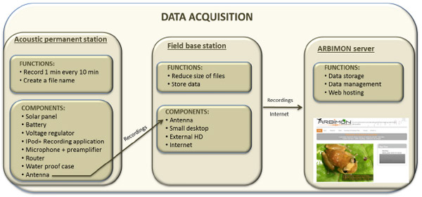 Call recognition for animals. New technology makes it possible to automatically identify species by their vocalizations. The software and hardware system, detailed in the current issue of the journal PeerJ, has been used at sites in Puerto Rico and Costa Rica to identify frogs, insects, birds, and monkeys. Many of the animals identified by the […]
Google puts $5M toward anti-poaching drone technology
- Google.org, Google Corp’s philanthropic arm, earlier this month pledged $5 million toward efforts combat wildlife poaching.
Feeds: news | india | latam | brasil | indonesia